


Neighborhoods of color are often more dangerous for pedestrians and cyclists, but they are also often left behind when local officials redesign streets to make them safer. How can we change this?
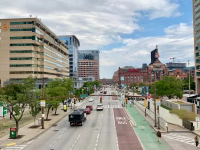
Baltimore bike lovers’ efforts to complete an extended network of protected bike lanes took a hit this summer.
City officials constructed the two-mile long, east-west portion of the route along East Monument Street, directly past Fountain Baptist Church. This is a largely Black area of the city where, according to census data, more than half of the population lives below the poverty line and most residents do not own a car.
After church leaders cried foul because they lost some on-street parking spots, the city removed a portion of the lane, redirecting southbound bike users to the sidewalk, over the objections of bike advocates who said that made the lane less safe.
The Fountain Baptist Church flap illustrates a problem plaguing communities nationwide. Neighborhoods with less affluence and with more people of color are often more dangerous for pedestrians and cyclists, but they are also often left out of the planning and design phases when local governments decide to redesign streets to make them safer for everyone. In the Baltimore case, the politically powerful church leaders exerted more influence than Complete Streets advocates.
Advocates for safer sidewalks and roadways say there are numerous reasons why marginalized communities would get a raw deal when it comes to Complete Streets, the increasingly popular transportation policy approach that envisions roadways that are designed to be safer for drivers, cyclists, and pedestrians.
Adonia Lugo, an urban anthropologist and board co-chair of Los Angeles-based People for Mobility Justice, says a major problem with the Complete Streets philosophy is that it’s focused on redesigning neighborhoods often with little or cursory input from the people who live in them.
”It’s just a reflection of the broader reality that a lot of times marginalized communities have not gotten to be participants in planning processes,” Lugo says.
FULL STORY: Bike Lanes Aren’t Just a White Thing

DOJ Seeks to End USDOT Affirmative Action Program
The Disadvantaged Business Enterprise Program encouraged contracting with minority- and women-owned businesses in the transportation sector, where these groups are vastly underrepresented.

Reflections on Representation and Legacy in Parks and Public Service
In a personal reflection for Asian American and Pacific Islander Heritage Month, planner Clement Lau explores how cultural identity, public service, and a commitment to equity have shaped his career in parks, community planning, and sustainability.

Integrating Human Rights Into Energy and Extractive Sector Transitions
Why just transition efforts must move beyond economic considerations by embedding human rights principles into business practices to ensure equitable, transparent, and accountable outcomes for affected communities and workers.

Planetizen Federal Action Tracker
A weekly monitor of how Trump’s orders and actions are impacting planners and planning in America.

Congressman Proposes Bill to Rename DC Metro “Trump Train”
The Make Autorail Great Again Act would withhold federal funding to the system until the Washington Metropolitan Area Transit Authority (WMATA), rebrands as the Washington Metropolitan Authority for Greater Access (WMAGA).

DARTSpace Platform Streamlines Dallas TOD Application Process
The Dallas transit agency hopes a shorter permitting timeline will boost transit-oriented development around rail stations.

Renters Now Outnumber Homeowners in Over 200 US Suburbs
High housing costs in city centers and the new-found flexibility offered by remote work are pushing more renters to suburban areas.

The Tiny, Adorable $7,000 Car Turning Japan Onto EVs
The single seat Mibot charges from a regular plug as quickly as an iPad, and is about half the price of an average EV.

Supreme Court Ruling in Pipeline Case Guts Federal Environmental Law
The decision limits the scope of a federal law that mandates extensive environmental impact reviews of energy, infrastructure, and transportation projects.
Urban Design for Planners 1: Software Tools
This six-course series explores essential urban design concepts using open source software and equips planners with the tools they need to participate fully in the urban design process.
Planning for Universal Design
Learn the tools for implementing Universal Design in planning regulations.
Municipality of Princeton
Roanoke Valley-Alleghany Regional Commission
City of Mt Shasta
City of Camden Redevelopment Agency
City of Astoria
Transportation Research & Education Center (TREC) at Portland State University
US High Speed Rail Association
City of Camden Redevelopment Agency
Municipality of Princeton (NJ)