


Phoenix's roads are the most dangerous in the state for pedestrians, but the city is taking little action to make them safer.
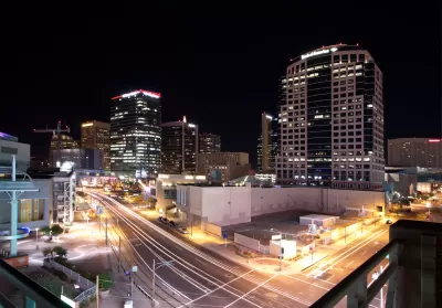
Agnel Philip and Bree Burkitt take a closer look at pedestrian safety in Phoenix. Of Arizona cities with populations greater than 10,000, Phoenix has the highest pedestrian death rate, and the number of deaths doubled between 2010 and 2017.
The city has put in 20 special crossing signals called HAWK signals, but Philip and Burkitt say the locations of the signals do not correspond with crash hot spots:
Despite the signals' potential to save lives, The Republic analysis showed the city is installing them in areas where no pedestrians were seriously injured or killed in recent years. Among the 23 signals the city has built or plans to build this year, half aren't within 300 feet of serious injury or fatality crashes during the period The Republic analyzed.
They also note that the most dangerous areas for pedestrians are on wide, high-speed roads with few crossings, which are common features of main thoroughfares in the city. While half of pedestrian deaths in Arizona involved individuals who were intoxicated, the speed of vehicles is also a key factor in the severity of pedestrian crashes, and activists are calling for design changes that would narrow roads and slow traffic.
"Dozens of cities across the United States have begun redesigning their streets in response to surging pedestrian death rates in recent years, setting a target of zero roadway deaths. But in Arizona, there's almost no commitment to that goal," say Philip and Burkitt.
FULL STORY: On Phoenix's most dangerous streets, little has been done to address the pedestrian death toll


Washington Focuses Road Safety Efforts on Individuals, Neglecting Design
Legislative efforts to reduce traffic deaths could move the needle toward Vision Zero, but state leaders failed to commit infrastructure funds to making structural improvements.
Louisiana Road Safety Plan Highlights Impaired Driving, Reckless Behavior
The plan focuses traffic safety efforts on distracted and impaired driving, seatbelt wearing, and speeding, with a small nod to infrastructural factors.

‘Complete Streets’ Webpage Deleted in Federal Purge
Basic resources and information on building bike lanes and sidewalks, formerly housed on the government’s Complete Streets website, are now gone.

Maui's Vacation Rental Debate Turns Ugly
Verbal attacks, misinformation campaigns and fistfights plague a high-stakes debate to convert thousands of vacation rentals into long-term housing.

Planetizen Federal Action Tracker
A weekly monitor of how Trump’s orders and actions are impacting planners and planning in America.

In Urban Planning, AI Prompting Could be the New Design Thinking
Creativity has long been key to great urban design. What if we see AI as our new creative partner?

Massachusetts Budget Helps Close MBTA Budget Gap
The budget signed by Gov. Maura Healey includes $470 million in MBTA funding for the next fiscal year.

Milwaukee Launches Vision Zero Plan
Seven years after the city signed its Complete Streets Policy, the city is doubling down on its efforts to eliminate traffic deaths.

Portland Raises Parking Fees to Pay for Street Maintenance
The city is struggling to bridge a massive budget gap at the Bureau of Transportation, which largely depleted its reserves during the Civd-19 pandemic.
Urban Design for Planners 1: Software Tools
This six-course series explores essential urban design concepts using open source software and equips planners with the tools they need to participate fully in the urban design process.
Planning for Universal Design
Learn the tools for implementing Universal Design in planning regulations.
Gallatin County Department of Planning & Community Development
Heyer Gruel & Associates PA
JM Goldson LLC
City of Camden Redevelopment Agency
City of Astoria
Transportation Research & Education Center (TREC) at Portland State University
Jefferson Parish Government
Camden Redevelopment Agency
City of Claremont