


Paris has made some incredibly ambitious and highly controversial policy changes to improve the city's air quality. In the meantime, there's a new app from Valeo to determine the state of the air quality in the city.
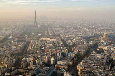
Jake Richardson shares news of a new app by Valeo that provides a real-time air quality map of the city of Paris, and could eventually navigates users around the areas with the worst air quality.
Valeo equipped 19 vehicles, 15 Keolis public transportation vehicles and four G7 Green taxis, with particle sensors. "Valeo’s sensors are designed to collect information on the concentration levels of various pollutants, including fine particles (PM 10 and PM 2.5), carbon monoxide, nitrogen dioxide, sulfur dioxide, and ozone," explains Richardson.
"Once recorded, these data points are fed into an instantaneous air quality index (AQI) map."
Eventually the app developers hope to allow navigation services that allow users to avoid areas in the city with the worst pollution.
FULL STORY: Real-Time Air Pollution Mapping In Paris Created By Valeo — #CleanTechnica Interview


Paris Bike Boom Leads to Steep Drop in Air Pollution
The French city’s air quality has improved dramatically in the past 20 years, coinciding with a growth in cycling.

New Google Map Layer Shows COVID-19 Infection Rates
A new layer showing the seven-day average of confirmed COVID-19 cases started rolling out to Android and iPhones last week.
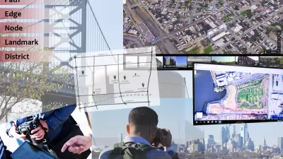
Analyzing Lynch's City Imageability in the Digital Age
Mahbubur Meenar of Rowan University writes about a recent article he co-authored in the Journal of Planning Education and Research

Maui's Vacation Rental Debate Turns Ugly
Verbal attacks, misinformation campaigns and fistfights plague a high-stakes debate to convert thousands of vacation rentals into long-term housing.

Planetizen Federal Action Tracker
A weekly monitor of how Trump’s orders and actions are impacting planners and planning in America.

In Urban Planning, AI Prompting Could be the New Design Thinking
Creativity has long been key to great urban design. What if we see AI as our new creative partner?

San Francisco Mayor Backtracks on Homelessness Goal
Mayor Dan Lurie ran on a promise to build 1,500 additional shelter beds in the city, complete with supportive services. Now, his office says they are “shifting strategy” to focus on prevention and mental health treatment.

How Trump's HUD Budget Proposal Would Harm Homelessness Response
Experts say the change to the HUD budget would make it more difficult to identify people who are homeless and connect them with services, and to prevent homelessness.

The Vast Potential of the Right-of-Way
One writer argues that the space between two building faces is the most important element of the built environment.
Urban Design for Planners 1: Software Tools
This six-course series explores essential urban design concepts using open source software and equips planners with the tools they need to participate fully in the urban design process.
Planning for Universal Design
Learn the tools for implementing Universal Design in planning regulations.
Gallatin County Department of Planning & Community Development
Heyer Gruel & Associates PA
JM Goldson LLC
Mpact (founded as Rail~Volution)
City of Camden Redevelopment Agency
City of Astoria
Jefferson Parish Government
Camden Redevelopment Agency
City of Claremont