


Jeff Speck's new book not only makes the case for narrow, walkable streets, but also provides more detailed guidance for specialists.

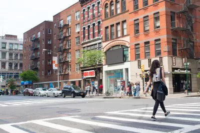
In the 2012 book Walkable City, Jeff Speck writes that cites can be walkable only if walking is useful, safe, comfortable and interesting. In his new book Walkable City Rules, he puts meat on the bones of this prescription, explaining how cities can achieve this goal.
Speck addresses usefulness by focusing on zoning and transit. In Walkable City, Speck emphasized that single-use zoning discouraged housing in otherwise walkable downtowns. In the new book, Speck urges cities to promote mixed use by enacting form-based codes, which allow a building to serve as housing, retail or both as long as It fits the city’s goals for a neighborhood. He also urges cities to encourage downtown housing through expedited permits and even tax abatements.
In Walkable City, Speck urges cities to place the most public transit in compact, walkable neighborhoods. But in Walkable City Rules, he also discusses transit that serves less walkable areas, suggesting that frequent service on a few bus routes is more desirable than hourly service on many, because "frequency is key to ridership." In addition, Speck believes that in all but the most compact cities, bus routes should be organized as a "simple grid, allowing quick L-shaped single-transfer trips from any one point to any other."
Speck devotes even more detailed attention to safety. In Walkable City, he endorses road diets (that is, reducing streets by a lane) in order to make cars go at safer, slower speeds. But in the newer book, Speck devotes six mini-chapters to reducing the number of car lanes, and four more to reducing lane width. For example, Speck writes that "streets with fewer than 1000 trips at peak hour need only two lanes." Although he believes that left-turn lanes are often desirable, Speck also suggests that on not-so-busy streets, such lanes may encourage speeding by providing unnecessary pavement space. So he praises an Oklahoma city engineer's decision that "no street handling fewer than 10000 cars per day would quality for left-turn lanes." While Walkable City praises on-street parking because it creates a buffer between pedestrians and moving cars, Walkable City Rules digs into the differences between parallel parking and angled parking, and proposes detailed standards for both. For example, he suggests that angled parking spaces typically require a zone 15-16.5 deep if they are at a 45-degree angle, and 16.5-18 feet deep if they are at a 60-degree angle.
In Walkable City, Speck's discussion of pedestrian comfort focused heavily on (among other issues) street trees. In that book he emphasized that street trees benefit pedestrians by offering protection from sun, wind and rain. In his new book, he not only restates the case for street trees, but digs into the details of urban forestry (pun intended). For example, he suggests that trees should not be planted more than 20-40 feet apart, because the most attractive tree canopies touch at maturity.
In Walkable City, Speck emphasizes that blank walls make walking boring. But in his new book, he shows how a city can address the blank walls it is stuck with, by placing murals and other public art on those blank walls.
In sum, Speck’s new book differs in kind from Walkable City. Walkable City was primarily an argument critiquing the status quo, designed as much for the general public as for architects and planners. Walkable City Rules is more of a best practices guide. Thus, this book is somewhat more specialist-oriented than Walkable City..
But Walkable City Rules is worth reading even for those of us who will never set foot in a planner's office. Like Walkable City, this book explains how a variety of laws and rules frustrate the person who wishes to get from one place to another on foot. But to a much greater extent than most books about walkability, this book tells readers what can be done to improve upon the status quo.

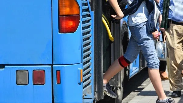
Opinion: Make Buses More Like Sidewalks
Sidewalks are an intuitive, low-cost, and easily accessible mobility tool. Can local buses function in the same way?

Report: Bus Ridership Back to 86 Percent of Pre-Covid Levels
Transit ridership around the country was up by 85 percent in all modes in 2024.

DC Metro Is Betting on Buses
The agency plans to significantly expand bus service, which can be added faster and at a lower cost than rail projects.

Planetizen Federal Action Tracker
A weekly monitor of how Trump’s orders and actions are impacting planners and planning in America.

San Francisco's School District Spent $105M To Build Affordable Housing for Teachers — And That's Just the Beginning
SFUSD joins a growing list of school districts using their land holdings to address housing affordability challenges faced by their own employees.

The Tiny, Adorable $7,000 Car Turning Japan Onto EVs
The single seat Mibot charges from a regular plug as quickly as an iPad, and is about half the price of an average EV.

With Protected Lanes, 460% More People Commute by Bike
For those needing more ammo, more data proving what we already knew is here.

In More Metros Than You’d Think, Suburbs are Now More Expensive Than the City
If you're moving to the burbs to save on square footage, data shows you should think again.

The States Losing Rural Delivery Rooms at an Alarming Pace
In some states, as few as 9% of rural hospitals still deliver babies. As a result, rising pre-term births, no adequate pre-term care and "harrowing" close calls are a growing reality.
Urban Design for Planners 1: Software Tools
This six-course series explores essential urban design concepts using open source software and equips planners with the tools they need to participate fully in the urban design process.
Planning for Universal Design
Learn the tools for implementing Universal Design in planning regulations.
Smith Gee Studio
City of Charlotte
City of Camden Redevelopment Agency
City of Astoria
Transportation Research & Education Center (TREC) at Portland State University
US High Speed Rail Association
City of Camden Redevelopment Agency
Municipality of Princeton (NJ)