


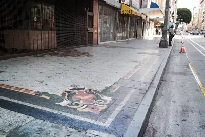
An app called Surveyor is making it easier to collect better data on curbs.
Kyle Wiggers reports on the startup Coord, which developed an app called Surveyor to locate curbs and catalog information about them. Existing data leaves a lot to be desired, says Wiggers:
The trouble is, the data’s often incomplete, and in some cases erroneous. Trees and other obstructions obscure street signs. Miscalibrated vehicle headings make it tough (and sometimes impossible) to suss out locations. And curb cuts, loading zones, meter prices, and curb paint aren’t consistently visible from street level.
The app allows users to mark the start and end of a curb space and note any features. Surveyor then adds the location to a 3-D map. So far, Coord has gathered data on 12,000 curbs in San Francisco and Los Angeles, along with earlier data it collected from 200,000 curbs in various cities and 86 percent of tollways in the United States, reports Wiggers.
Coord’s broader goal is to provide data to public agencies and companies on different modes and street elements, says Wiggers:
Toll agencies can tap Coord’s APIs [application programming interface] to calculate toll prices and communicate them through an app, for example, and bike-sharing companies could leverage its location datasets to pinpoint stations on a map. And cities can use it to better allocate parking zones and manage the flow of traffic.
Surveyor is currently a subscription service that helps participating organizations and agencies develop local databases.
FULL STORY: Coord’s Surveyor app uses AR to map curbs and sidewalks

Next on the List for Data Startups: Managing Curb Space
The humble curb is getting crowded: not only with new modes of transportation, but also with a slew of new data tools aiming to keep track of it all.
Mapping the Law of the Land: Curbside Access
More uses and modes than ever are fighting for curb space in growing cities. Here's an app to make sense of what you can do, and when, along this valued real estate.

State of Curbs & Parking Report Reveals Glut of Data
As the uses of curb space become more diverse, city officials are working to understand how to best manage this increasingly important urban amenity.

Planetizen Federal Action Tracker
A weekly monitor of how Trump’s orders and actions are impacting planners and planning in America.

San Francisco's School District Spent $105M To Build Affordable Housing for Teachers — And That's Just the Beginning
SFUSD joins a growing list of school districts using their land holdings to address housing affordability challenges faced by their own employees.

The Tiny, Adorable $7,000 Car Turning Japan Onto EVs
The single seat Mibot charges from a regular plug as quickly as an iPad, and is about half the price of an average EV.

Trump Approves Futuristic Automated Texas-Mexico Cargo Corridor
The project could remove tens of thousands of commercial trucks from roadways.

Austin's First Single Stair Apartment Building is Officially Underway
Eliminating the requirement for two staircases in multi-story residential buildings lets developers use smaller lots and more flexible designs to create denser housing.

Atlanta Bus System Redesign Will Nearly Triple Access
MARTA's Next Gen Bus Network will retool over 100 bus routes, expand frequent service.
Urban Design for Planners 1: Software Tools
This six-course series explores essential urban design concepts using open source software and equips planners with the tools they need to participate fully in the urban design process.
Planning for Universal Design
Learn the tools for implementing Universal Design in planning regulations.
Smith Gee Studio
City of Charlotte
City of Camden Redevelopment Agency
City of Astoria
Transportation Research & Education Center (TREC) at Portland State University
City of Camden Redevelopment Agency
Municipality of Princeton (NJ)