


The long-term closure of Teton Pass following major damage caused by a landslide will have far-reaching economic impacts on the region, residents, and visitors.
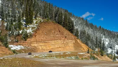
The Wyoming Department of Transportation announced on Saturday that part of Teton Pass, “a crucial highway weaving through the mountains of western Wyoming,” collapsed in a massive landslide, according to an CBS News article. The landslide “effectively destroyed a whole section of the surrounding highway,” writes CBS reporter by Emily Mae Czachor. Fortunately, no one was injured.
Officials have not released a timeline for repair but said it will likely be closed long-term, which is a major concern for the surrounding region because the pass is the primary transit route between Victor, Idaho, and Jackson, Wyoming, and provides “vital access to Teton County, which includes Jackson, Yellowstone and Grand Teton, for workers who commute there from eastern Idaho,” Czachor reports. Because of the mountainous terrain, the detour route roughly triples the normal 30-minute travel time between Victor and Jackson.
The region is bracing for economic consequences. According to the CBS article, workers who live in Idaho and commute to Teton County make up about 40 percent of the county’s workforce. A long-term closure will have both impacts on those workers, as well as services for visitors and locals in Teton County during the height of the summer tourist season.
FULL STORY: Part of Wyoming highway collapses in landslide, blocking crucial commuter transit route


Los Angeles to Test Road Closure Through Scenic Griffith Park
After a driver killed a cyclist on Griffith Park Drive in April, the city of Los Angeles is studying safety upgrades on streets in its famous park. The L.A. Times says the changes are part of a growing movement.

Report: Collapsed Mexico City Train Line Had Major Structural Flaws
A New York Times investigation uncovered years of government documents showing that officials ignored warnings about major structural flaws and poorly performed work on the train line before its fatal collapse in May.
Blaming ERCOT
The Electric Reliability Council of Texas (ERCOT), the nonprofit, independent power grid operator for 90 percent of the nation's second-largest state, has become the convenient fall guy for the epic power failure caused by an extreme weather event.

Planetizen Federal Action Tracker
A weekly monitor of how Trump’s orders and actions are impacting planners and planning in America.

Maui's Vacation Rental Debate Turns Ugly
Verbal attacks, misinformation campaigns and fistfights plague a high-stakes debate to convert thousands of vacation rentals into long-term housing.

Restaurant Patios Were a Pandemic Win — Why Were They so Hard to Keep?
Social distancing requirements and changes in travel patterns prompted cities to pilot new uses for street and sidewalk space. Then it got complicated.

In California Battle of Housing vs. Environment, Housing Just Won
A new state law significantly limits the power of CEQA, an environmental review law that served as a powerful tool for blocking new development.

Boulder Eliminates Parking Minimums Citywide
Officials estimate the cost of building a single underground parking space at up to $100,000.

Orange County, Florida Adopts Largest US “Sprawl Repair” Code
The ‘Orange Code’ seeks to rectify decades of sprawl-inducing, car-oriented development.
Urban Design for Planners 1: Software Tools
This six-course series explores essential urban design concepts using open source software and equips planners with the tools they need to participate fully in the urban design process.
Planning for Universal Design
Learn the tools for implementing Universal Design in planning regulations.
Heyer Gruel & Associates PA
JM Goldson LLC
Custer County Colorado
City of Camden Redevelopment Agency
City of Astoria
Transportation Research & Education Center (TREC) at Portland State University
Jefferson Parish Government
Camden Redevelopment Agency
City of Claremont