


Brightline West hopes to break ground, in anticipation of a 2027 opening. Cities in the Inland Empire and High Desert areas of Southern California are looking to take advantage.
“If planning gives way to a ribbon-cutting on-schedule in 2027 — Brightline wants to operate a the line for a full year in advance of the 2028 Olympics in Los Angeles — the line could transform Rancho Cucamonga, link exurban desert communities to Los Angeles, and boost the economy of the entire Inland Empire.”
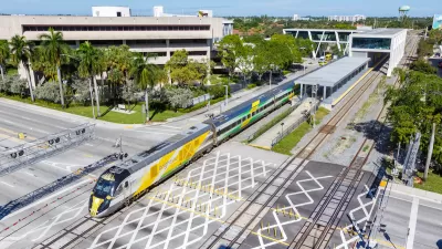
“In total, the line will run 218 miles, largely within the median of Interstate 15, at speeds to up to 186 miles per hour. The line will briefly travel through the heavily urbanized areas of the western Inland Empire, then go through the Cajon Pass, and travel 185 miles mostly unimpeded through the Mojave Desert. The right-of-way offers distinct advantages: the line will be built in an already developed area, with easy access for construction crews, and it will only minimally disrupt the desert habitat that lines the majority of the route.”
“In the meantime, passengers will be able to park and catch the train in Apple Valley — both for trip to Las Vegas and to Rancho Cucamonga. As part of its collaboration with the San Bernardino County Transportation Authority, Brightline will welcome passengers who use the train as commuter rail, presumably from less expensive housing in the high desert to the job centers of the Inland Empire — and, possibly, to those of Las Vegas as well.”
FULL STORY: Inland Empire, High Desert Anticipate Brightline West Rail Line


Car-Centric LA Suburb Looks to a Train-Oriented Future
City leaders in Rancho Cucamonga, the future western terminus of the Brightline West rail line to Las Vegas, want to reimagine the city as a transit-oriented, pedestrian-friendly community.

Brightline West Moves Forward With Finalized Federal Funding
The high-speed rail line will connect Southern California and Las Vegas via a two-hour trip along Interstate 15.
Brightline Founder Predicts a Passenger Rail Resurgence
The HSR operator wants to expand to more US regions.

Planetizen Federal Action Tracker
A weekly monitor of how Trump’s orders and actions are impacting planners and planning in America.

Maui's Vacation Rental Debate Turns Ugly
Verbal attacks, misinformation campaigns and fistfights plague a high-stakes debate to convert thousands of vacation rentals into long-term housing.

San Francisco Suspends Traffic Calming Amidst Record Deaths
Citing “a challenging fiscal landscape,” the city will cease the program on the heels of 42 traffic deaths, including 24 pedestrians.

Amtrak Rolls Out New Orleans to Alabama “Mardi Gras” Train
The new service will operate morning and evening departures between Mobile and New Orleans.

The Subversive Car-Free Guide to Trump's Great American Road Trip
Car-free ways to access Chicagoland’s best tourist attractions.

San Antonio and Austin are Fusing Into one Massive Megaregion
The region spanning the two central Texas cities is growing fast, posing challenges for local infrastructure and water supplies.
Urban Design for Planners 1: Software Tools
This six-course series explores essential urban design concepts using open source software and equips planners with the tools they need to participate fully in the urban design process.
Planning for Universal Design
Learn the tools for implementing Universal Design in planning regulations.
Heyer Gruel & Associates PA
JM Goldson LLC
Custer County Colorado
City of Camden Redevelopment Agency
City of Astoria
Transportation Research & Education Center (TREC) at Portland State University
Jefferson Parish Government
Camden Redevelopment Agency
City of Claremont