


A never-completed freeway segment could see new life as a mixed-use development with housing, commercial space, and one of the county’s largest parks.
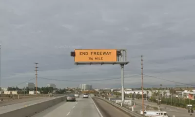
A Los Angeles freeway segment—alternately known as the Marina Freeway, “the Slauson Freeway, the Richard M. Nixon Freeway and, as Johnny Carson once mocked it, the Slauson Cutoff”—could make way for housing and a massive park, if a group of community activists has its way.
“The vision, said Michael Schneider, chief executive and founder of Streets For All, is to transform the road that was left incomplete in the 1960s into about 130 acres of green space and nearly 4,000 residential units,” reports Salvador Hernandez in the Los Angeles Times.
The proposal would allocate about half of the site to open space. “The project, across roughly 128 acres, would include 11 four-story mixed-use buildings, with the first floor used for businesses and the remaining floors for homes. The plan would reconnect neighborhoods that sit on opposite sides of the 90 Freeway and provide access to Centinela Creek, the Ballona Creek trail and Ballona Wetlands Ecological Reserve.”
Streets For All plans to apply for a grant from the federal Reconnecting Communities and Neighborhoods Act to fund a feasibility study.
FULL STORY: This L.A. freeway is the butt of many jokes. Can it have new life as parks and housing?


Dead End: Nine Highways Ready for Retirement
The Freeways Without Futures report describes the nation’s most promising highway removal proposals.

How South LA Green Spaces Power Community Health and Hope
Green spaces like South L.A. Wetlands Park are helping South Los Angeles residents promote healthy lifestyles, build community, and advocate for improvements that reflect local needs in historically underserved neighborhoods.
Los Angeles County Invests in Wildfire Recovery for Parks, Trails, and Open Space
The $4.25 million RESTORE Program supports the recovery of parks, trails, and open spaces damaged by the January 2025 wildfires through targeted grants that promote community healing, wildfire resilience, and equitable access to nature.

Planetizen Federal Action Tracker
A weekly monitor of how Trump’s orders and actions are impacting planners and planning in America.

Maui's Vacation Rental Debate Turns Ugly
Verbal attacks, misinformation campaigns and fistfights plague a high-stakes debate to convert thousands of vacation rentals into long-term housing.

San Francisco Suspends Traffic Calming Amidst Record Deaths
Citing “a challenging fiscal landscape,” the city will cease the program on the heels of 42 traffic deaths, including 24 pedestrians.

Amtrak Rolls Out New Orleans to Alabama “Mardi Gras” Train
The new service will operate morning and evening departures between Mobile and New Orleans.

The Subversive Car-Free Guide to Trump's Great American Road Trip
Car-free ways to access Chicagoland’s best tourist attractions.

San Antonio and Austin are Fusing Into one Massive Megaregion
The region spanning the two central Texas cities is growing fast, posing challenges for local infrastructure and water supplies.
Urban Design for Planners 1: Software Tools
This six-course series explores essential urban design concepts using open source software and equips planners with the tools they need to participate fully in the urban design process.
Planning for Universal Design
Learn the tools for implementing Universal Design in planning regulations.
Heyer Gruel & Associates PA
JM Goldson LLC
Custer County Colorado
City of Camden Redevelopment Agency
City of Astoria
Transportation Research & Education Center (TREC) at Portland State University
Jefferson Parish Government
Camden Redevelopment Agency
City of Claremont