


A proposed plan to build a new city in the Bay Area is light on details and heavy on idyllic renderings.
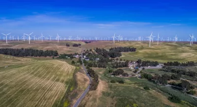
A newly revealed set of AI-generated (and occasionally impossible) renderings provide a vague vision of a proposed new city backed by tech financing.
But as Kyle Barr points out in Gizmodo, “You don’t have to stray too far into science fiction or comic book tales to find examples of megalomaniacal tech businessmen creating their own ‘utopian’ metropolises, before—inevitably—everything goes to hell.”
The renderings provided by California Forever, the parent company of project developer Flannery Associates, “show a sunny green town sitting amid rolling hills, farms, and windmills. The text describes a walkable city with solar farms, open land, and ‘good-paying local jobs.’ The company even says it’s ‘also interested’ in looking at ways to support homeownership using down-payment assistance,” according to an article by Wes Davis in The Verge. But “The website is otherwise pretty light on details about the city itself, with no specifics about a population, its size, or how it will sustain itself.”
Barr’s Gizmodo article adds, “Flannery Associates said it has purchased more than 50,000 acres in eastern Solano County since 2018. Previous reports showed the company spent more than $800 million buying up parcels of farmland in the Bay Area from Fairfield all the way to Rio Vista, though up until now there had been little to no communication from the company about why, and what the hell they planned to build.”
The project would still need approval from local officials and would require a ballot initiative to permit development on land zoned for agriculture.
FULL STORY: ‘California Forever’ website touts the city tech billionaires are trying to build


‘California Forever’ Withdraws Ballot Measure
The company will delay taking its high-tech planned community proposal to Solano County voters to conduct an environmental impact report and work with the city on zoning changes.
Why California Should Not, Cannot Solve Its Housing Crisis By Building New Cities
A recent essay advocates for the development of a new city in California to alleviate the state's housing crisis. The argument needs a few tweaks.

In Urban Planning, AI Prompting Could be the New Design Thinking
Creativity has long been key to great urban design. What if we see AI as our new creative partner?

Planetizen Federal Action Tracker
A weekly monitor of how Trump’s orders and actions are impacting planners and planning in America.

Maui's Vacation Rental Debate Turns Ugly
Verbal attacks, misinformation campaigns and fistfights plague a high-stakes debate to convert thousands of vacation rentals into long-term housing.

Restaurant Patios Were a Pandemic Win — Why Were They so Hard to Keep?
Social distancing requirements and changes in travel patterns prompted cities to pilot new uses for street and sidewalk space. Then it got complicated.

In California Battle of Housing vs. Environment, Housing Just Won
A new state law significantly limits the power of CEQA, an environmental review law that served as a powerful tool for blocking new development.

Boulder Eliminates Parking Minimums Citywide
Officials estimate the cost of building a single underground parking space at up to $100,000.

Orange County, Florida Adopts Largest US “Sprawl Repair” Code
The ‘Orange Code’ seeks to rectify decades of sprawl-inducing, car-oriented development.
Urban Design for Planners 1: Software Tools
This six-course series explores essential urban design concepts using open source software and equips planners with the tools they need to participate fully in the urban design process.
Planning for Universal Design
Learn the tools for implementing Universal Design in planning regulations.
Heyer Gruel & Associates PA
JM Goldson LLC
Custer County Colorado
City of Camden Redevelopment Agency
City of Astoria
Transportation Research & Education Center (TREC) at Portland State University
Jefferson Parish Government
Camden Redevelopment Agency
City of Claremont