


The latest update to a state-mandated coastal protection and restoration plan calls for wetlands restoration and new levees to protect communities from flooding.
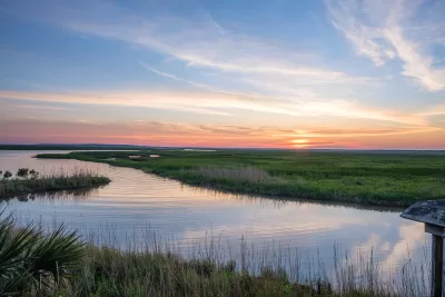
The state of Louisiana has approved a 50-year plan for restoring and bolstering its coastal defenses as the state loses thousands of square miles of wetlands to the effects of storms and infrastructure like canals, levees, and dams.
As David Kidd explains in Governing, “The loss of millions of acres of wetlands has left Louisiana with fewer natural defenses against future storm surge flooding and rising sea levels that threaten coastal communities and industries alike.”
The Coastal Protection and Restoration Authority (CPRA), created in the wake of Hurricane Katrina in 2005, coordinates federal and state coastal restoration efforts and guides investment. The agency updates its master plan every six years.
“The 2023 Coastal Master Plan calls for 77 projects aimed at preserving and protecting the coast, including the restoration and maintenance of over 300 square miles of Louisiana’s wetlands. Projects are chosen for their long-term viability and whether or not restored lands will survive 50 years or more.” The plan also “identifies a dozen risk reduction projects, including building new levees and strengthening existing barriers to protect communities from flooding.”
FULL STORY: Louisiana’s Plan to Defend Against Storms and Rising Sea Levels

Louisiana Coastal Protection Agency Under Threat
The state’s new governor wants to shrink the power of the agency, which has spearheaded essential flood protection and mitigation efforts since the aftermath of Hurricane Katrina.

NYC Completes North Section of Coastal Resiliency Project
The city is raising shorelines and building protective gates to prevent future flooding and storm surges from impacting residents.

NOAA Releases High-Resolution Coastal Data
The new data can help communities identify risks and assess potential land use impacts in coastal areas.

Maui's Vacation Rental Debate Turns Ugly
Verbal attacks, misinformation campaigns and fistfights plague a high-stakes debate to convert thousands of vacation rentals into long-term housing.

Planetizen Federal Action Tracker
A weekly monitor of how Trump’s orders and actions are impacting planners and planning in America.

San Francisco Suspends Traffic Calming Amidst Record Deaths
Citing “a challenging fiscal landscape,” the city will cease the program on the heels of 42 traffic deaths, including 24 pedestrians.

Defunct Pittsburgh Power Plant to Become Residential Tower
A decommissioned steam heat plant will be redeveloped into almost 100 affordable housing units.

Trump Prompts Restructuring of Transportation Research Board in “Unprecedented Overreach”
The TRB has eliminated more than half of its committees including those focused on climate, equity, and cities.

Amtrak Rolls Out New Orleans to Alabama “Mardi Gras” Train
The new service will operate morning and evening departures between Mobile and New Orleans.
Urban Design for Planners 1: Software Tools
This six-course series explores essential urban design concepts using open source software and equips planners with the tools they need to participate fully in the urban design process.
Planning for Universal Design
Learn the tools for implementing Universal Design in planning regulations.
Heyer Gruel & Associates PA
JM Goldson LLC
Custer County Colorado
City of Camden Redevelopment Agency
City of Astoria
Transportation Research & Education Center (TREC) at Portland State University
Jefferson Parish Government
Camden Redevelopment Agency
City of Claremont