


The city hopes that permitting larger ADUs and making adaptive reuse easier will help it meet its state-mandated goal of building over 8,000 new housing units by 2031.

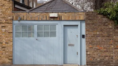
Santa Barbara will now allow larger and taller accessory dwelling units (ADUs) in residential areas, as well as secondary ADUs on the second floor of commercial properties on the city’s popular State Street, reports Joshua Molina for Noozhawk.
“Many of the changes were technical and small in nature, but the more significant revisions include allowing the height of attached ADUs to rise from 18 feet to 25 feet and detached ADUs to increase from 17 feet to 18 feet,” Molina explains.
Santa Barbara officials believe expanding their ADU program will help bring more housing to the city while maintaining its character. According to the city, “Santa Barbara has received 928 applications for accessory dwelling units since 2017. Of those, 416 have been built and another 216 are in the pipeline.”
The new rules are partly a response to California’s Regional Housing Needs Allocation (RHNA), which requires municipalities to take actions to boost housing production based on state-assigned targets. Statewide, California cities are tasked with building over 2.5 million housing units by 2031, with Santa Barbara accounting for 8,001 required units.
FULL STORY: Santa Barbara City Council Moves to Allow Larger, Taller Accessory Dwelling Units


Texas Legislature’s Surprising Pro-Housing Swing
Smaller homes on smaller lots, office to apartment conversions, and 40% less say for NIMBYs, vote state lawmakers.

Iowa Legalizes Accessory Dwelling Units
A new law will allow property owners to build ADUs on single-family lots starting on July 1.
Are ADUs New Jersey’s Affordable Housing Solution?
Accessory units can bring gentle density increases and boost the housing supply with minimal impact on local infrastructure.

Planetizen Federal Action Tracker
A weekly monitor of how Trump’s orders and actions are impacting planners and planning in America.

Restaurant Patios Were a Pandemic Win — Why Were They so Hard to Keep?
Social distancing requirements and changes in travel patterns prompted cities to pilot new uses for street and sidewalk space. Then it got complicated.

Map: Where Senate Republicans Want to Sell Your Public Lands
For public land advocates, the Senate Republicans’ proposal to sell millions of acres of public land in the West is “the biggest fight of their careers.”

Maui's Vacation Rental Debate Turns Ugly
Verbal attacks, misinformation campaigns and fistfights plague a high-stakes debate to convert thousands of vacation rentals into long-term housing.

San Francisco Suspends Traffic Calming Amidst Record Deaths
Citing “a challenging fiscal landscape,” the city will cease the program on the heels of 42 traffic deaths, including 24 pedestrians.

California Homeless Arrests, Citations Spike After Ruling
An investigation reveals that anti-homeless actions increased up to 500% after Grants Pass v. Johnson — even in cities claiming no policy change.
Urban Design for Planners 1: Software Tools
This six-course series explores essential urban design concepts using open source software and equips planners with the tools they need to participate fully in the urban design process.
Planning for Universal Design
Learn the tools for implementing Universal Design in planning regulations.
Heyer Gruel & Associates PA
JM Goldson LLC
Custer County Colorado
City of Camden Redevelopment Agency
City of Astoria
Transportation Research & Education Center (TREC) at Portland State University
Camden Redevelopment Agency
City of Claremont
Municipality of Princeton (NJ)