


After voting to lower speed limits citywide, Richmond found itself with a $5.2 million bill for new signage, prompting the city council to pull the ordinance.
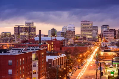
When the Richmond, Virginia city council voted to lower its default speed limit to 20 miles per hour in an effort to reduce the risk of death or severe injury in crashes involving pedestrians, they were told that the change would cost $5.2 million.
As Wyatt Gordon explains in Greater Greater Washington, lowering speed limits is shown to vastly improve the chances of survival during a crash. “A person hit by a car traveling 30 mph is 70% more likely to be killed than if struck by a driver going 25 mph, for example. Assuming Richmonders one day follow a citywide 20 mph default speed limit, pedestrians would face a 93% chance of surviving any given crash in the River City.”
But Richmond city officials are interpreting the change to mean a new speed limit sign on every block, which drives up the cost of the project. As Amy Robins, council liaison for the 5th district, explained, “Our office couldn’t justify that amount spent on signs versus narrowing roads and adding bike lanes and raised crosswalks, so we pulled the ordinance.” The ordinance also would not have applied to state-owned streets that pass through Richmond.
“For now, Richmond residents can submit a request for a new speed limit sign on their streets as low as 15 mph via the RVA 311 app.” Out of 15 civic associations in the 5th District, 14 have already applied for lower speed limits, signaling a strong demand for safer streets. According to Gordon, “Del. Carr plans to introduce a bill to the General Assembly this month that would remove the need for costly individual block signage and traffic studies, and allow any Virginia locality to instead post default speed limit signs at its borders to notify drivers of the lower limit.”
FULL STORY: Why should it cost $5.2 million to lower the speed limit 5 mph in Richmond?


Vehicle-related Deaths Drop 29% in Richmond, VA
The seventh year of the city's Vision Zero strategy also cut the number of people killed in alcohol-related crashes by half.

Chicago Could Join Other Cities in Lowering Speed Limits
Lowering speed limits by just 10 miles per hour can have a major impact on traffic safety.
Philly Speed Camera Program Cuts Fatalities in Half
Excessive speeding along dangerous segments of Roosevelt Boulevard dropped by 90 percent after the city installed automated enforcement cameras.

Planetizen Federal Action Tracker
A weekly monitor of how Trump’s orders and actions are impacting planners and planning in America.

Chicago’s Ghost Rails
Just beneath the surface of the modern city lie the remnants of its expansive early 20th-century streetcar system.

San Antonio and Austin are Fusing Into one Massive Megaregion
The region spanning the two central Texas cities is growing fast, posing challenges for local infrastructure and water supplies.

Since Zion's Shuttles Went Electric “The Smog is Gone”
Visitors to Zion National Park can enjoy the canyon via the nation’s first fully electric park shuttle system.

Trump Distributing DOT Safety Funds at 1/10 Rate of Biden
Funds for Safe Streets and other transportation safety and equity programs are being held up by administrative reviews and conflicts with the Trump administration’s priorities.

German Cities Subsidize Taxis for Women Amid Wave of Violence
Free or low-cost taxi rides can help women navigate cities more safely, but critics say the programs don't address the root causes of violence against women.
Urban Design for Planners 1: Software Tools
This six-course series explores essential urban design concepts using open source software and equips planners with the tools they need to participate fully in the urban design process.
Planning for Universal Design
Learn the tools for implementing Universal Design in planning regulations.
planning NEXT
Appalachian Highlands Housing Partners
Mpact (founded as Rail~Volution)
City of Camden Redevelopment Agency
City of Astoria
City of Portland
City of Laramie