


A nine-month bus rapid transit planning process, one of the key components of the Cincinnati region’s “Reinventing Metro” long-range transit plan, launched recently.
Cincinnati has launched a planning process for bus rapid transit (BRT) additions to its public transit system as part of the Reinventing Metro plan approved by Hamilton County voters in 2020.
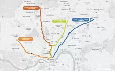
According to the Reinventing Metro website, the BRT planning is underway as a collaboration between Cincinnati’s Metro and the Southwest Ohio Regional Transit Authority (SORTA). A nine-month study will narrow down the choices along four corridors identified by Reinventing Metro as the most popular transit corridors in the Metro system: Glenway Avenue, Hamilton Avenue, Reading Road, and Montgomery Road.
Chris Wetterich reports on the bus rapid transit plans in a paywalled article for the Cincinnati Business Courier. In 2021, the Cincinnati Business Courier identified bus rapid transit [paywall] as one of the most critical infrastructure projects for the region.
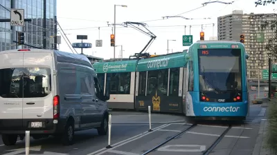
Public transit has faced challenges in Cincinnati in recent years, so successful planning of BRT routes would go a long way to instilling public faith in transit in the region. Despite voters approving the sales tax necessary to support Reinventing Metro, the Cincinnati Bell Connector streetcar has been dogged by political opposition, management crises, and low ridership from its inception.
FULL STORY: Cincinnati Metro to vet where to build bus rapid transit lines


Transit Improvements Coming to Cincinnati Area After Voters Approve New Sales Tax
Hamilton County, Ohio, home to Cincinnati and the Southwest Ohio Regional Transit Authority, has a new coffer of money to fund public transit improvements.

400 Stops Removed From the Cincinnati Metro Bus System
The process of reducing the number of stops on a transit line—known as bus stop thinning, consolidation, or balancing—took effect this week in Cincinnati. Reducing the number of stops is intended to speed up buses and improve reliability.
Management Divorce for the Cincinnati Streetcar
Efforts to bolster support for a countywide sales tax levy in Hamilton County, Ohio, are pushing the city to fire SORTA as the manager of the troubled Cincinnati Bell Connector.

Maui's Vacation Rental Debate Turns Ugly
Verbal attacks, misinformation campaigns and fistfights plague a high-stakes debate to convert thousands of vacation rentals into long-term housing.

Planetizen Federal Action Tracker
A weekly monitor of how Trump’s orders and actions are impacting planners and planning in America.

San Francisco Suspends Traffic Calming Amidst Record Deaths
Citing “a challenging fiscal landscape,” the city will cease the program on the heels of 42 traffic deaths, including 24 pedestrians.

Defunct Pittsburgh Power Plant to Become Residential Tower
A decommissioned steam heat plant will be redeveloped into almost 100 affordable housing units.

Trump Prompts Restructuring of Transportation Research Board in “Unprecedented Overreach”
The TRB has eliminated more than half of its committees including those focused on climate, equity, and cities.

Amtrak Rolls Out New Orleans to Alabama “Mardi Gras” Train
The new service will operate morning and evening departures between Mobile and New Orleans.
Urban Design for Planners 1: Software Tools
This six-course series explores essential urban design concepts using open source software and equips planners with the tools they need to participate fully in the urban design process.
Planning for Universal Design
Learn the tools for implementing Universal Design in planning regulations.
Heyer Gruel & Associates PA
JM Goldson LLC
Custer County Colorado
City of Camden Redevelopment Agency
City of Astoria
Transportation Research & Education Center (TREC) at Portland State University
Jefferson Parish Government
Camden Redevelopment Agency
City of Claremont