


The CoolClimate Network's Interactive Policy Tools calculate and compare the GHG reductions provided by various emission reduction policies. These tools can help households, businesses and communities identify the best emission reduction strategies.
The climate crisis is pressing and solutions are urgently needed. The University of California, Berkeley's CoolClimate Network provides smart decision-making tools and programs to accelerate the transition to a clean energy economy. It is developing cutting-edge carbon footprint benchmarking research and combining this with ongoing lessons from behavioral sciences to design tailored climate solutions for specific users and populations.
CoolClimate tools can quickly identify the unique opportunities each individual, business, organization or community holds to reduce greenhouse gas emisions. These tools are incorporated into programs to activate, educate, motivate and empower individuals and organizations to make low-carbon choices.
These include:
Household Calculator. This calculates the emissions of specific households, taking into account their specific location, housing, transportation and consumption patterns, and ways that these can be reduced.
Business Calculator. This calculates the emissions of specific businesses, taking into account their specific location, housing, transportation and consumption patterns, and ways that these can be reduced.
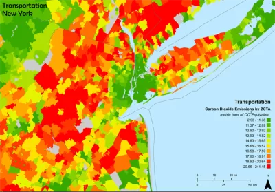
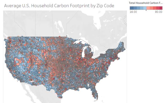
CoolClimate Maps. These custom heatmaps show household carbon emission rates for specific locations.
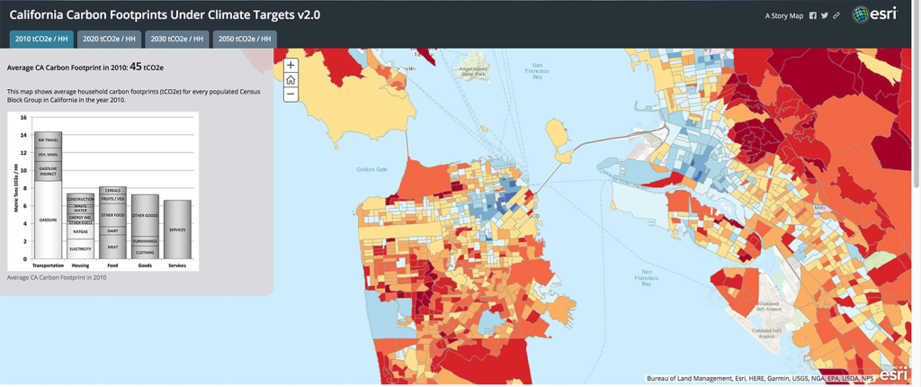
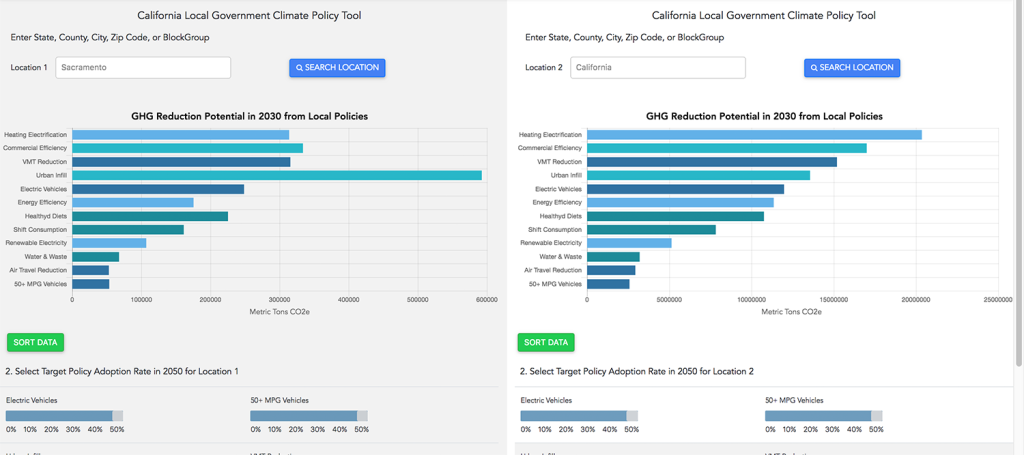
California Carbon Footprint Planning Tools and Scenarios
CoolClimate API allows software developers to create custom Carbon Footprint Calculators.
These tools are useful, interesting and fun to use, and produce beautiful maps. They are based on extensive and ongoing research concerning emission sources and the effectiveness of emission reduction strategies.


What Makes Affordable Housing Green?
There's no one way to determine what makes “green” housing. Here's a breakdown of the standards and considerations used by the affordable housing industry.

Oregon to End Sales of Gas-Powered Vehicles by 2035
There must be something about having a coast on the Pacific Ocean that makes states set policies to accelerate the end of the internal combustion engine.

COP27 Climate Negotiations Produce a Mixed Bag
Negotiators at this year’s COP27 climate change meetings can claim progress on some tricky issues, but stagnation reigns on the fundamental issue of emission reductions.

Maui's Vacation Rental Debate Turns Ugly
Verbal attacks, misinformation campaigns and fistfights plague a high-stakes debate to convert thousands of vacation rentals into long-term housing.

Planetizen Federal Action Tracker
A weekly monitor of how Trump’s orders and actions are impacting planners and planning in America.

San Francisco Suspends Traffic Calming Amidst Record Deaths
Citing “a challenging fiscal landscape,” the city will cease the program on the heels of 42 traffic deaths, including 24 pedestrians.

Defunct Pittsburgh Power Plant to Become Residential Tower
A decommissioned steam heat plant will be redeveloped into almost 100 affordable housing units.

Trump Prompts Restructuring of Transportation Research Board in “Unprecedented Overreach”
The TRB has eliminated more than half of its committees including those focused on climate, equity, and cities.

Amtrak Rolls Out New Orleans to Alabama “Mardi Gras” Train
The new service will operate morning and evening departures between Mobile and New Orleans.
Urban Design for Planners 1: Software Tools
This six-course series explores essential urban design concepts using open source software and equips planners with the tools they need to participate fully in the urban design process.
Planning for Universal Design
Learn the tools for implementing Universal Design in planning regulations.
Heyer Gruel & Associates PA
JM Goldson LLC
Custer County Colorado
City of Camden Redevelopment Agency
City of Astoria
Transportation Research & Education Center (TREC) at Portland State University
Jefferson Parish Government
Camden Redevelopment Agency
City of Claremont