


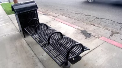
‘Defensive urbanism’ interventions explicitly seek to repel certain, often vulnerable, social groups from public spaces.
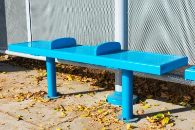
In an article for Canadian Architect, Pamela Young highlights the work of Cara Chellew, a researcher who documents “hostile design,” defined as “urban interventions that restrict behaviour, defending spaces against unwanted occupation by skateboarders and unhoused people.”
Based on the work of British artist Stuart Semple, the concept of “hostile design,” also known as defensive urbanism, calls attention to the elements of urban design that aim to make ostensibly public space unwelcoming to certain populations. Chellew’s research maps defensive urbanism examples in Toronto. In addition to physical elements that aim to repel “loiterers,” Chellew also includes “ghost amenities” that no longer exist: “Permanently out-of-service drinking fountains, locked or non-existent park washrooms, and ‘shade structures’ that filter sunlight but let rain flood through all have an impact on how shared outdoor space can be used—and who uses it.”
Researchers like Chellew and Nadia Galati, a principal at PROCESS, argue that designing cities for the most vulnerable groups creates more accessible and pleasant public spaces for everyone. Galati recommends implementing a paid community engagement process for new parks and public space projects, whereby residents are paid for their participation in order to attract more input from underrepresented groups.
FULL STORY: Don’t Get Defensive


One Year Into Brazil’s ‘Hostile Architecture’ Ban
A recent law prohibits ‘defensive’ architecture designed to keep people away from buildings or public spaces.
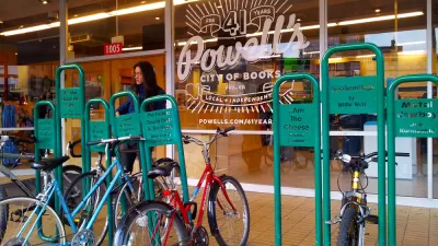
How Bike Racks Are Weaponized To Displace Unhoused People
In Portland, a set of mysteriously installed bike racks is prompting questions about their true purpose.
Philadelphia Park Designed for, not Against, People Experiencing Homelessness
In an effort to make public spaces more inclusive, a new pocket park in the Callowhill neighborhood will seek input from people experiencing homelessness on how to make the space more welcoming and functional.

Planetizen Federal Action Tracker
A weekly monitor of how Trump’s orders and actions are impacting planners and planning in America.

DARTSpace Platform Streamlines Dallas TOD Application Process
The Dallas transit agency hopes a shorter permitting timeline will boost transit-oriented development around rail stations.

Four Reasons Urban Planners Can’t Ignore AI
It’s no longer a question of whether AI will shape planning, but how. That how is up to us.

Amtrak’s Borealis Exceeds First Year Ridership Expectations
205,800 passengers have boarded the St. Paul to Chicago line, well above initial MDOT projections.

Study: 4% of Truckers Lack a Valid Commercial License
Over 56% of inspected trucks had other violations.

Chicago Judge Orders Thousands of Accessible Ped Signals
Only 3% of the city's crossing signals are currently accessible to blind pedestrians.
Urban Design for Planners 1: Software Tools
This six-course series explores essential urban design concepts using open source software and equips planners with the tools they need to participate fully in the urban design process.
Planning for Universal Design
Learn the tools for implementing Universal Design in planning regulations.
City of Mt Shasta
City of Camden Redevelopment Agency
City of Astoria
Transportation Research & Education Center (TREC) at Portland State University
US High Speed Rail Association
City of Camden Redevelopment Agency
Municipality of Princeton (NJ)