


The Pennsylvania Avenue Initiative seeks to redesign the capital’s most famous thoroughfare to include more park space and pedestrian amenities.
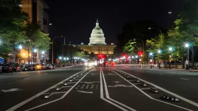
“Urban planners want to re-imagine downtown D.C.’s Pennsylvania Avenue as a signature outdoor venue, emphasizing people over cars and expanding park space between the White House and the U.S. Capitol.” As reported by Alejandro Alvarez, the Pennsylvania Avenue Initiative has proposed three potential makeovers of the famous street. “The three visions deal with different approaches to balancing pedestrian needs, recreational space and vehicle traffic, citing a 2018 D.C. transportation study that found up to 20 feet of the avenue’s current lanes could be allocated to other uses while preserving an ‘acceptable’ level of service (LOS) for vehicles.”
One plan would focus on sidewalk expansion without changing much else about existing traffic patterns. A second, “ would transform wide swathes of Pennsylvania Avenue into a curb-less pedestrian park with winding footpaths and large lawns, leaving a vestige of the roadway at its center for public transit and bike use.” The third concept would “would bisect the avenue with a mile-long central pedestrian promenade running its entire length, flanked on both sides by a combination of narrower travel and bike lanes.”
According to the article, “Planners also identified three popular public spaces along Pennsylvania Avenue, roughly correlating to the areas around Freedom Plaza, the Navy Memorial and John Marshall Park, that would be expanded under each proposal ‘to encourage a range of plaza and park-related activities with retail services and amenities.’” The Initiative’s StoryMaps site features renderings and maps of the proposed concepts.
FULL STORY: Urban planners detail 3 ways to re-imagine DC’s Pennsylvania Avenue


Milwaukee Road to Get Complete Streets Upgrades
The city will reduce vehicle lanes and build a protected multi-use trail including bioswales and other water retention features on its ‘secret highway.’
Indy Neighborhood Group Builds Temporary Multi-Use Path
Community members, aided in part by funding from the city, repurposed a vehicle lane to create a protected bike and pedestrian path for the summer season.

Has Progress on Travel Safety Run Off the Road?
Changing technology and rebuilding infrastructure to improve road safety are long-term strategies. How can enforcement and interventions that influence driver behavior make a difference in reducing traffic deaths sooner?

Maui's Vacation Rental Debate Turns Ugly
Verbal attacks, misinformation campaigns and fistfights plague a high-stakes debate to convert thousands of vacation rentals into long-term housing.

Planetizen Federal Action Tracker
A weekly monitor of how Trump’s orders and actions are impacting planners and planning in America.

In Urban Planning, AI Prompting Could be the New Design Thinking
Creativity has long been key to great urban design. What if we see AI as our new creative partner?

King County Supportive Housing Program Offers Hope for Unhoused Residents
The county is taking a ‘Housing First’ approach that prioritizes getting people into housing, then offering wraparound supportive services.

Researchers Use AI to Get Clearer Picture of US Housing
Analysts are using artificial intelligence to supercharge their research by allowing them to comb through data faster. Though these AI tools can be error prone, they save time and housing researchers are optimistic about the future.

Making Shared Micromobility More Inclusive
Cities and shared mobility system operators can do more to include people with disabilities in planning and operations, per a new report.
Urban Design for Planners 1: Software Tools
This six-course series explores essential urban design concepts using open source software and equips planners with the tools they need to participate fully in the urban design process.
Planning for Universal Design
Learn the tools for implementing Universal Design in planning regulations.
planning NEXT
Appalachian Highlands Housing Partners
Mpact (founded as Rail~Volution)
City of Camden Redevelopment Agency
City of Astoria
City of Portland
City of Laramie