


With Vision Zero faltering around the country, maybe it's time to get back to the fundamentals of street design. An example from Cincinnati shows how street improvements can achieve significant improvements with relatively little expense.

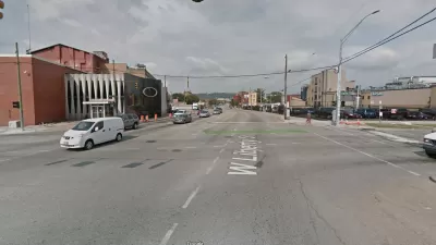
"Cincinnati's Department of Transportation & Engineering will be installing speed cushions throughout the city after their temporary use in Winton Hills significantly dropped speeds for traveling vehicles," reports Allison Babka for CityBeat.
The rubber cushions, "which look like two speed humps side by side," helped reduce average automobile speed from 37 mph to 20 mph since they were installed on Winneste Avenue in Winston Hills, according to a February 7 report detailing the effects of the pilot project.
Just 11% of vehicles exceeded the posted speed limit of 25mph after installation. Before that, 95% did," writes Babka for additional insight into the results of the experiment.
The pilot project and the report are the result of the city's Vision Zero initiative. In another recent Vision Zero pilot project, the city's Department of Transportation & Engineering in December began testing plastic curb extensions at the intersection of Hamilton Avenue and Pullan Avenue in Northside. "The curb extensions prevent motorists from passing in the parking lane, and force traffic into one travel lane, slowing speeds into the pedestrian-friendly neighborhood business district," according to the city's website.
As reported by Babka, the city of Cincinnati claims to have implemented 200 pedestrian safety projects in 37 neighborhoods in 2021. In 2022, the city has budgeted $1.25 million for more pedestrian safety improvements.
FULL STORY: Cincinnati to Add More Speed-Reduction Cushions After Successful Pilot Program

Cincinnati Gets Serious About Pedestrian Safety
A new in-house team dedicated to pedestrian safety at Cincinnati City Hall and a new complete streets ordinance are some of the changes underway in Cincinnati.

Let’s End Traffic Stops
The technology to make traffic enforcement obsolete is becoming available. But in the U.S. willing to use it?
Cincinnati To Consider $1 Million Traffic Calming Program
A proposal before Cincinnati's city council would boost traffic calming initiatives and use innovative technology to slow traffic on some of the city's most dangerous streets.

Maui's Vacation Rental Debate Turns Ugly
Verbal attacks, misinformation campaigns and fistfights plague a high-stakes debate to convert thousands of vacation rentals into long-term housing.

Planetizen Federal Action Tracker
A weekly monitor of how Trump’s orders and actions are impacting planners and planning in America.

In Urban Planning, AI Prompting Could be the New Design Thinking
Creativity has long been key to great urban design. What if we see AI as our new creative partner?

Portland Raises Parking Fees to Pay for Street Maintenance
The city is struggling to bridge a massive budget gap at the Bureau of Transportation, which largely depleted its reserves during the Civd-19 pandemic.

Spokane Mayor Introduces Housing Reforms Package
Mayor Lisa Brown’s proposals include deferring or waiving some development fees to encourage more affordable housing development.

Houston Mayor Kills Another Bike Lane
The mayor rejected a proposed bike lane in the Montrose district in keeping with his pledge to maintain car lanes.
Urban Design for Planners 1: Software Tools
This six-course series explores essential urban design concepts using open source software and equips planners with the tools they need to participate fully in the urban design process.
Planning for Universal Design
Learn the tools for implementing Universal Design in planning regulations.
Gallatin County Department of Planning & Community Development
Heyer Gruel & Associates PA
JM Goldson LLC
City of Camden Redevelopment Agency
City of Astoria
Transportation Research & Education Center (TREC) at Portland State University
Jefferson Parish Government
Camden Redevelopment Agency
City of Claremont