


As Oregon's coastal beaches erode, taking valued public space with them and exposing private property to increased risks from flooding and sea-level rise, some local governments want to allow property owners the right to "armor" the coast.
After decades of enforcing a state law banning construction of rip-rap, or a barrier constructed of large rocks, along the coastline, Tillamook County, Oregon has decided to toss the state law and allow coastal homeowners to reinforce the coastline to protect their homes, according to an article by Kristian Foden-Vencil for OPB.
"Oregon land-use rules largely ban shoreline armoring, under what’s known as Goal 18," explains Foden-Vencil in the article. "The policy, adopted back in 1977, banned the use of rip rap to protect new development, unless the site qualified for an exception."
Goal 18 was adopted to protect the natural features of the Oregon Coast, but scientists have also shown that rip rap "changes the wave action on a beach, scouring away sand and potentially leaving no beach for the public to enjoy," according to the article.
"So there’s a natural friction between the hundreds of thousands of Oregonians who live on the coast and want their properties protected from the ocean, and environmentalists and visitors who vacation here and want to protect the beautiful vistas."
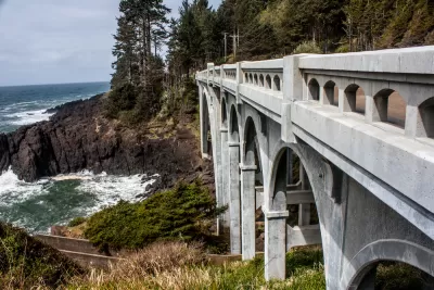
As reported in the source article below, Tillamook County, located on the Oregon Coast directly west of Portland but south of the mouth of the Columbia River, has recently begun to favor rip rap over public beaches.
But environmentalists aren't allowing the shift in land use policy without a legal fight. "The Oregon Shores Conservation Coalition is fighting Tillamook County’s decision and taking the Pine Beach case to Oregon’s Land Use Board of Appeals, or LUBA. They’re joined in their case by the Surfrider Foundation and the Oregon Department of Land Conservation and Development," reports Foden -Vencil.
FULL STORY: Oregon’s land-use rules bump up against increasingly crowded shorelines


Florida Homeowners 'Nope Out' of Beach Restoration Over Public Access
The U.S. Corps of Engineers and Redington Shores, Florida are at a standstill: The Corps won’t spend public money to restore private beaches, and homeowners are refusing to grant public access to the beaches behind their home in return for federal assistance.

Lawsuit Could Open Public Access to Colorado Rivers
Colorado is one of few U.S. states that has decided that private property owners supersede the public when it comes to access to rivers and streams.

Beachfront Residences Can't Extend Yards Onto Public Beaches, CA Coastal Commission Decides
"It's like squatting by the rich," said one commissioner.

Planetizen Federal Action Tracker
A weekly monitor of how Trump’s orders and actions are impacting planners and planning in America.

San Francisco's School District Spent $105M To Build Affordable Housing for Teachers — And That's Just the Beginning
SFUSD joins a growing list of school districts using their land holdings to address housing affordability challenges faced by their own employees.

The Tiny, Adorable $7,000 Car Turning Japan Onto EVs
The single seat Mibot charges from a regular plug as quickly as an iPad, and is about half the price of an average EV.

Seattle's Plan for Adopting Driverless Cars
Equity, safety, accessibility and affordability are front of mind as the city prepares for robotaxis and other autonomous vehicles.

As Trump Phases Out FEMA, Is It Time to Flee the Floodplains?
With less federal funding available for disaster relief efforts, the need to relocate at-risk communities is more urgent than ever.

With Protected Lanes, 460% More People Commute by Bike
For those needing more ammo, more data proving what we already knew is here.
Urban Design for Planners 1: Software Tools
This six-course series explores essential urban design concepts using open source software and equips planners with the tools they need to participate fully in the urban design process.
Planning for Universal Design
Learn the tools for implementing Universal Design in planning regulations.
Smith Gee Studio
City of Charlotte
City of Camden Redevelopment Agency
City of Astoria
Transportation Research & Education Center (TREC) at Portland State University
US High Speed Rail Association
City of Camden Redevelopment Agency
Municipality of Princeton (NJ)