


Analysis of cell phone location tracking data shows changes in how Californians have moved around since the pandemic.
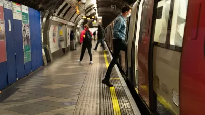
How have the mobility patterns of California changed since March 2020 due to the pandemic? Mobile phone location data can help to answer this question. As reported by Phillip Reese, Google has compiled large amounts of cell phone location tracking data as part of its ongoing effort to help leaders around the world to gauge the impact of COVID-related closures and travel restrictions. Collected from phones with location trackers enabled, the mobility logs show patterns of trip frequency—available at national, state and regional levels—in daily snapshots from early 2020 through early March 2021. The baseline for comparison in terms of trip frequency is the first five weeks of 2020, before California and the United States initiated broad COVID-related restrictions.
Some of the key findings of this analysis are:
- In the early weeks of 2021, Californians are staying home way more than we did in our pre-pandemic life.
- Californians are using cars rather than resuming pre-COVID commute patterns on public transit, i.e. buses and trains, which is a trend with troubling implications for transit services and the environment should it become long-standing.
- As of early March 2021, travel for retail and restaurants was back to 26% below the baseline, while grocery and pharmacy trips were 11% below.
- Work-related travel showed the most sustained disruption, at 33% below the baseline.
- Californians are heading out to shop, dine, and work far more now than in March 2020, when the state issued its first sweeping stay-at-home order.
Please read the source article for more details, including informative graphs and maps.
FULL STORY: How COVID-19 Has Changed Movement in the Nation's Most Populous State

What Is the Future for Transit After COVID? - A Debate
Critic Randal O'Toole and advocate Todd Litman debate how communities should plan for public transit in the post pandemic future. Should it contract or expand?

Most Questions About the Long-Term Impact of the Pandemic Still Unanswered
Planetizen started gathering articles attempting to predict the post-pandemic future in March 2020. The work goes on, with many questions left still to be answered.

Haves and Have Nots: Planning and the Deep Divides of the Pandemic
The latest in a series of compendia gathering news and analysis about the effects of the COVID-19 on the built and natural environments—now and long into the future.

Planetizen Federal Action Tracker
A weekly monitor of how Trump’s orders and actions are impacting planners and planning in America.

Maui's Vacation Rental Debate Turns Ugly
Verbal attacks, misinformation campaigns and fistfights plague a high-stakes debate to convert thousands of vacation rentals into long-term housing.

Restaurant Patios Were a Pandemic Win — Why Were They so Hard to Keep?
Social distancing requirements and changes in travel patterns prompted cities to pilot new uses for street and sidewalk space. Then it got complicated.

In California Battle of Housing vs. Environment, Housing Just Won
A new state law significantly limits the power of CEQA, an environmental review law that served as a powerful tool for blocking new development.

Boulder Eliminates Parking Minimums Citywide
Officials estimate the cost of building a single underground parking space at up to $100,000.

Orange County, Florida Adopts Largest US “Sprawl Repair” Code
The ‘Orange Code’ seeks to rectify decades of sprawl-inducing, car-oriented development.
Urban Design for Planners 1: Software Tools
This six-course series explores essential urban design concepts using open source software and equips planners with the tools they need to participate fully in the urban design process.
Planning for Universal Design
Learn the tools for implementing Universal Design in planning regulations.
Heyer Gruel & Associates PA
JM Goldson LLC
Custer County Colorado
City of Camden Redevelopment Agency
City of Astoria
Transportation Research & Education Center (TREC) at Portland State University
Jefferson Parish Government
Camden Redevelopment Agency
City of Claremont