


The city hopes for "transformative" solutions to reinvigorate the auto-centric parkway and create safer paths for people walking and biking.
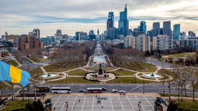
Philadelphia is seeking proposals to redesign the Benjamin Franklin Parkway with a stronger focus on bike and pedestrian infrastructure, reports Ryan Briggs for WHYY. "The joint RFP, filed by the Department of Parks and Recreation, the Office of Transportation Infrastructure and Sustainability and the Mayor’s Fund, calls for a total redo of Eakins Oval –– including the removal of a surface parking lot –– and better infrastructure for public gatherings." City leaders want to make the space between Logan Circle and the Philadelphia Art Museum a more accessible, more usable "pedestrian-oriented civic space."
Similar projects have added "scattered—and sometimes temporary—improvements" along other stretches of the parkway, and officials hope the new project will unify what Parks and Rec Commissioner Kathryn Ott Lovell calls Philadelphia's "Champs-Élysées." The Parisian boulevard, in fact, heavily influenced the 1917 design for the Franklin Parkway. But the road has become increasingly hostile to pedestrians. "Subsequent redesigns grappled with a complex traffic pattern that included intersections with Kelly Drive, Martin Luther King Drive, the Spring Garden Bridge, and other city streets. The construction of interstates 76 and 676 in the later 20th century added dedicated highway ramp spurs along the southern portions of the Parkway, further complicating foot access."
With the project in its earliest stages, the city says it is "open to ambitious solutions" and hopes to see some "transformative ideas" for the historic roadway.
FULL STORY: Philly’s iconic Ben Franklin Parkway to get a major redesign


Philadelphia Launches Plan To Redesign Ben Franklin Parkway
The city wants to make the car-centric parkway more accessible and people-friendly.
Quality Bike Infrastructure Saved Lives During the Pandemic, Study Says
Evidence from Arlington, Virginia.
The Once and Future Park Avenue Promenade
The debate about whether the pedestrian-oriented changes made to the New York City streetscape during the pandemic should be permanent has a high-profile battleground on Park Avenue.

Planetizen Federal Action Tracker
A weekly monitor of how Trump’s orders and actions are impacting planners and planning in America.

Maui's Vacation Rental Debate Turns Ugly
Verbal attacks, misinformation campaigns and fistfights plague a high-stakes debate to convert thousands of vacation rentals into long-term housing.

Restaurant Patios Were a Pandemic Win — Why Were They so Hard to Keep?
Social distancing requirements and changes in travel patterns prompted cities to pilot new uses for street and sidewalk space. Then it got complicated.

In California Battle of Housing vs. Environment, Housing Just Won
A new state law significantly limits the power of CEQA, an environmental review law that served as a powerful tool for blocking new development.

Boulder Eliminates Parking Minimums Citywide
Officials estimate the cost of building a single underground parking space at up to $100,000.

Orange County, Florida Adopts Largest US “Sprawl Repair” Code
The ‘Orange Code’ seeks to rectify decades of sprawl-inducing, car-oriented development.
Urban Design for Planners 1: Software Tools
This six-course series explores essential urban design concepts using open source software and equips planners with the tools they need to participate fully in the urban design process.
Planning for Universal Design
Learn the tools for implementing Universal Design in planning regulations.
Heyer Gruel & Associates PA
JM Goldson LLC
Custer County Colorado
City of Camden Redevelopment Agency
City of Astoria
Transportation Research & Education Center (TREC) at Portland State University
Jefferson Parish Government
Camden Redevelopment Agency
City of Claremont