


A new 13-mile regional trail opens in South Los Angeles, connecting various parks to the Pacific Ocean and providing additional opportunities for residents to enjoy outdoor recreation during a pandemic.
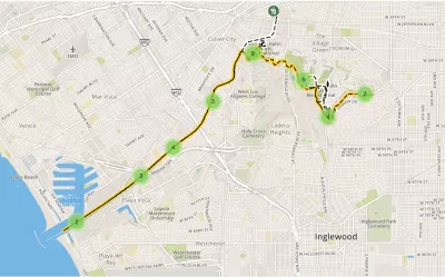
In the midst of the COVID-19 pandemic, parks and trails have become very popular destinations for people seeking respite and opportunities to exercise and be active. To the delight of Angelenos, a new trail has opened in Los Angeles County, offering yet another recreational option. The 13-mile Park to Playa Trail connects the Baldwin Hills Parklands to the Pacific Ocean via the Stocker Corridor, Kenneth Hahn State Recreation Area, Stoneview Nature Center, the Baldwin Hills Scenic Overlook, and Ballona Creek Bike Path.
The trail does not just physically connect various communities and parks to the Pacific Ocean, it also offers residents opportunities to connect with nature and with each other.
In its entirety, the trail represents a $23 million investment in outdoor recreation for the Baldwin Hills and surrounding communities. An additional $20.5 million was invested in new amenities along the trail, including in the development of the Stoneview Nature Center, Milton Street Park, and the Martin Luther King Jr. Memorial Tree Grove, as well as the transformation of the community center at Kenneth Hahn State Recreation Area into a state-of-the-art Interpretive Center in addition to a variety of other accessibility, habitat restoration, and recreational improvements within the parklands.
FULL STORY: Building a Bridge from Baldwin Hills to the Beach: 13-Mile Trail Now Open

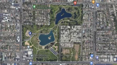
Transformation of South Los Angeles Park Offers Hope to the Community
Earvin "Magic" Johnson Park in Willowbrook has been transformed with $70 million worth of improvements, including a 20,000-square foot event center for community gatherings and events.

Creativity Needed to Meet Recreational Needs During a Pandemic
With COVID-19, the Los Angeles County Department of Parks and Recreation modified its popular Parks After Dark program so that it could still meet community needs, while complying with public health orders.

Expanding Green Spaces in Greater LA: Challenges and Solutions
Creating parks and open space in L.A. County requires overcoming land scarcity, high costs, and other challenges through strategic partnerships, innovative multi-benefit designs, and policy reforms to ensure equitable access and sustainability.

Maui's Vacation Rental Debate Turns Ugly
Verbal attacks, misinformation campaigns and fistfights plague a high-stakes debate to convert thousands of vacation rentals into long-term housing.

Planetizen Federal Action Tracker
A weekly monitor of how Trump’s orders and actions are impacting planners and planning in America.

San Francisco Suspends Traffic Calming Amidst Record Deaths
Citing “a challenging fiscal landscape,” the city will cease the program on the heels of 42 traffic deaths, including 24 pedestrians.

Half of Post-Fire Altadena Home Sales Were to Corporations
Large investors are quietly buying up dozens of properties in Altadena, California, where a devastating wildfire destroyed more than 6,000 homes in January.

Opinion: What San Francisco’s Proposed ‘Family Zoning’ Could Really Mean
Mayor Lurie is using ‘family zoning’ to encourage denser development and upzoning — but could the concept actually foster community and more human-scale public spaces?

Jacksonville Launches First Autonomous Transit Shuttle in US
A fleet of 14 fully autonomous vehicles will serve a 3.5-mile downtown Jacksonville route with 12 stops.
Urban Design for Planners 1: Software Tools
This six-course series explores essential urban design concepts using open source software and equips planners with the tools they need to participate fully in the urban design process.
Planning for Universal Design
Learn the tools for implementing Universal Design in planning regulations.
Gallatin County Department of Planning & Community Development
Heyer Gruel & Associates PA
JM Goldson LLC
City of Camden Redevelopment Agency
City of Astoria
Transportation Research & Education Center (TREC) at Portland State University
Jefferson Parish Government
Camden Redevelopment Agency
City of Claremont