


What happens to Play Streets when playing together is a danger?
Elissaveta M. Brandon writes for Next City:
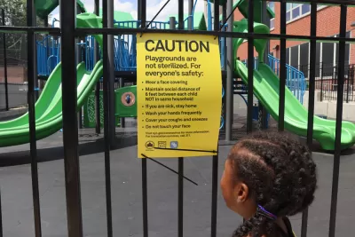
It is a hot and humid Tuesday in Red Hook, Brooklyn, but a few brave children have come out to play. Stretching along a segment of 9th Street, between Hicks and Henry, a colorful obstacle course welcomes its first guests for the day. A little girl hops over the hurdles, hand in hand with her mother. A young boy follows suit, surgical mask strapped around his face and wet Crocs squeaking from the open fire hydrant across the street. It is 1p.m, and the Red Hook Open Street is open for play.
Play streets — an intervention that helps increase outdoor play by temporarily closing designated public streets to traffic — are a long-standing tradition in New York City, but the pandemic has put them at risk. Last month, Mayor Bill de Blasio brought a little bit of them back with a new initiative aimed at providing families with safe, structured activities in the wake of COVID-19. The revamped Play Streets initiative builds on Open Streets — a program that allows pedestrians and cyclists to use the roadbed of the street to allow for greater social distancing — and includes programs like giant board games, reading corners and sports for children. As a part of Play Streets, New York City-based organization Street Lab has even re-invented the obstacle course to allow for social play in a time of social distancing.
The article continues at the link below.
FULL STORY: How to Design a Street for Hands-Off Play

Against 'Pandemic-Friendly' Planning
Since COVID-19 won't last forever, planners should not act as if it will, according to this opinion.
How Oakland Is Fixing its Pandemic Planning Equity Problem
The Oakland Slow Streets program, one of the most controversial developments of the early pandemic, has evolved to become the Essential Places initiative, thanks to new planning practices and a commitment to equity in Oakland, California.
Strange Days: Outrage Absent as Businesses Reclaim Parking Spots
It took a pandemic, but the worldwide effort to move restaurant and retail businesses outside, at the expense of parking, is proving far less controversial than it would have before the coronavirus swept the globe.

Planetizen Federal Action Tracker
A weekly monitor of how Trump’s orders and actions are impacting planners and planning in America.

Maui's Vacation Rental Debate Turns Ugly
Verbal attacks, misinformation campaigns and fistfights plague a high-stakes debate to convert thousands of vacation rentals into long-term housing.

San Francisco Suspends Traffic Calming Amidst Record Deaths
Citing “a challenging fiscal landscape,” the city will cease the program on the heels of 42 traffic deaths, including 24 pedestrians.

Amtrak Rolls Out New Orleans to Alabama “Mardi Gras” Train
The new service will operate morning and evening departures between Mobile and New Orleans.

The Subversive Car-Free Guide to Trump's Great American Road Trip
Car-free ways to access Chicagoland’s best tourist attractions.

San Antonio and Austin are Fusing Into one Massive Megaregion
The region spanning the two central Texas cities is growing fast, posing challenges for local infrastructure and water supplies.
Urban Design for Planners 1: Software Tools
This six-course series explores essential urban design concepts using open source software and equips planners with the tools they need to participate fully in the urban design process.
Planning for Universal Design
Learn the tools for implementing Universal Design in planning regulations.
Heyer Gruel & Associates PA
JM Goldson LLC
Custer County Colorado
City of Camden Redevelopment Agency
City of Astoria
Transportation Research & Education Center (TREC) at Portland State University
Jefferson Parish Government
Camden Redevelopment Agency
City of Claremont