


Montgomery County planners recommend the implementation of sidewalks, crosswalks, and bike lanes on streets within a half-mile radius of Purple Line light-rail stations.

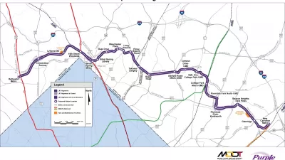
According to a new study conducted by planners in Montgomery County, Maryland, suburban streets surrounding Purple Line stations need improved sidewalks and crosswalks to allow safer access for pedestrians. Purple Line riders are expected to access the train primarily on foot as the stations are designed to utilize only existing parking infrastructure. "With most Purple Line passengers expected to reach stations by walking, in addition to bus, making surrounding roads more comfortable for pedestrians will be key to their safety and willingness to use the new light-rail system," reports Katherine Shaver.
Within a half-mile radius of the ten Purple Line stations in the county, planners found that most streets have too narrow or no sidewalks as well as a similar lack of marked crosswalks. Shaver says the planners recommend a speed reduction from 30-40 mph to 25 mph within the half-mile radius from stations. Improving the pedestrian-friendliness of the streets in the car-dominated suburbs will include widening sidewalks, adding bike lanes, increasing visibility of crosswalks, and landscaping to create a buffer between cars and pedestrians. Shaver says "planners recommend prioritizing improvements in communities with lower household incomes and more minority residents because they have some of the most dangerous walking conditions and have been underserved historically."
FULL STORY: Purple Line stations need safer access for pedestrians, planners say

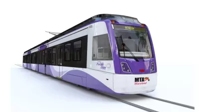
Maryland's Purple Line Gets the Green Light Again
The public-private partnership behind the Purple Line light rail project in Maryland fell apart in September, and has this past week been revived.
Purple Line Construction Halts in Maryland as Contractor Woes Deepen
Purple Line Transit Partners, the contractors managing construction of the beleaguered Purple Line in Maryland, have begun to walk off the job as a dispute about cost overruns brings the project to a screeching halt.
Preserving Affordable Housing Along Maryland Light Rail Line
A new plan lays out strategies to keep housing affordable for low- and moderate-income residents along the corridor of Maryland’s new Purple Line.

Planetizen Federal Action Tracker
A weekly monitor of how Trump’s orders and actions are impacting planners and planning in America.

Map: Where Senate Republicans Want to Sell Your Public Lands
For public land advocates, the Senate Republicans’ proposal to sell millions of acres of public land in the West is “the biggest fight of their careers.”

Restaurant Patios Were a Pandemic Win — Why Were They so Hard to Keep?
Social distancing requirements and changes in travel patterns prompted cities to pilot new uses for street and sidewalk space. Then it got complicated.

Platform Pilsner: Vancouver Transit Agency Releases... a Beer?
TransLink will receive a portion of every sale of the four-pack.

Toronto Weighs Cheaper Transit, Parking Hikes for Major Events
Special event rates would take effect during large festivals, sports games and concerts to ‘discourage driving, manage congestion and free up space for transit.”

Berlin to Consider Car-Free Zone Larger Than Manhattan
The area bound by the 22-mile Ringbahn would still allow 12 uses of a private automobile per year per person, and several other exemptions.
Urban Design for Planners 1: Software Tools
This six-course series explores essential urban design concepts using open source software and equips planners with the tools they need to participate fully in the urban design process.
Planning for Universal Design
Learn the tools for implementing Universal Design in planning regulations.
Heyer Gruel & Associates PA
JM Goldson LLC
Custer County Colorado
City of Camden Redevelopment Agency
City of Astoria
Transportation Research & Education Center (TREC) at Portland State University
Camden Redevelopment Agency
City of Claremont
Municipality of Princeton (NJ)