


A group called Safe Embarcadero for All is suing to block the construction of a homeless shelter on city-leased land across from piers 30-32 on the San Francisco waterfront.
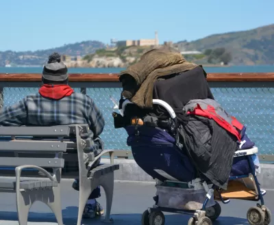
"Opponents of a 200-bed Navigation Center planned for the Embarcadero filed a lawsuit against the project Wednesday in an attempt to stop the city from building the homeless shelter in their neighborhood," reports Trisha Thadani.
"Last month, the group was unsuccessful in trying to persuade the supervisors to overturn a unanimous April decision by the San Francisco Port Commission to grant the city a two-year lease on its 2.3-acre parcel across from Piers 30-32," according to Thadani.
This month, a lawsuit, which makes arguments similar to the appeal: "that the city failed to get the necessary approvals from the State Lands Commission, the agency that oversees waterfront development. It also argues that the city did not go through a proper environmental and design review and seeks a restraining order to halt the development from progressing until the lawsuit is decided."
A spokesperson for the city is quoted in the article saying the city followed all applicable land use laws when approving the navigation center, also implying that the opposition group is a "not in my back yard" (NIMBY) organization.
FULL STORY: Residents file lawsuit against Embarcadero Navigation Center

Court Ruling a Setback for California’s ‘Builder’s Remedy’
A state court has ruled in favor of the San Francisco Board of Supervisors’ efforts to block a development project despite the state’s efforts to intervene.
The Causes of California's Development Malaise
A spate of recent articles has taken a critical look at the regulatory obstacles to a progrssive planning vision in the state of California.
Amid Opposition, S.F. Homeless Navigation Center Completed
A new facility providing shelter and services to San Francisco’s homeless will open this month, even after a year of community pushback.

Planetizen Federal Action Tracker
A weekly monitor of how Trump’s orders and actions are impacting planners and planning in America.

Restaurant Patios Were a Pandemic Win — Why Were They so Hard to Keep?
Social distancing requirements and changes in travel patterns prompted cities to pilot new uses for street and sidewalk space. Then it got complicated.

Map: Where Senate Republicans Want to Sell Your Public Lands
For public land advocates, the Senate Republicans’ proposal to sell millions of acres of public land in the West is “the biggest fight of their careers.”

Maui's Vacation Rental Debate Turns Ugly
Verbal attacks, misinformation campaigns and fistfights plague a high-stakes debate to convert thousands of vacation rentals into long-term housing.

San Francisco Suspends Traffic Calming Amidst Record Deaths
Citing “a challenging fiscal landscape,” the city will cease the program on the heels of 42 traffic deaths, including 24 pedestrians.

California Homeless Arrests, Citations Spike After Ruling
An investigation reveals that anti-homeless actions increased up to 500% after Grants Pass v. Johnson — even in cities claiming no policy change.
Urban Design for Planners 1: Software Tools
This six-course series explores essential urban design concepts using open source software and equips planners with the tools they need to participate fully in the urban design process.
Planning for Universal Design
Learn the tools for implementing Universal Design in planning regulations.
Heyer Gruel & Associates PA
JM Goldson LLC
Custer County Colorado
City of Camden Redevelopment Agency
City of Astoria
Transportation Research & Education Center (TREC) at Portland State University
Camden Redevelopment Agency
City of Claremont
Municipality of Princeton (NJ)