


Vox and Curbed provide multi-media coverage of a Staten Island sea wall project as an example of the necessity of resilient infrastructure, and the shortcomings of our ability to predict the needs of the built environments in changed climates.
Sister sites Vox and Curbed teamed up for a video and news article collaboration on the subject of New York City's plans to protect Staten Island from sea level rise and climate change by building a massive barrier.
According to the original article, written by Nathan Kensinger for Curbed, the South Shore of Staten Island Coastal Storm Risk Management Project would build a 5.3-mile long barrier from Fort Wadsworth to Oakwood Beach. "The United States Army Corps of Engineers (USACE) is now planning to break ground on this $615 million project in 2020, and expects it to be finished in approximately four years," according to Kensinger.
The project is "staggering in scope," according to Kensinger: "It will include a 4.3-mile seawall with a public promenade built on top, one mile of levees and floodwalls, and more than 180 acres of newly excavated stormwater detention ponds. The project encompasses an area with over 30,000 residents and 7,300 structures, and will protect some of the coastal neighborhoods that suffered the worst damage during Hurricane Sandy, including Arrochar, South Beach, Ocean Breeze, Graham Beach, Midland Beach, New Dorp Beach, and Oakwood Beach."
Kensinger's longread coverage of the project ranges from accounts of the devastation from Superstorm Sandy to the other big sea-level rise resilience projects in the works around New York, such as the East Side Coastal Resiliency Project, which would protect a stretch of Manhattan coastline. The article is also thoroughly supplemented with illustrative photographic examples of damage from Sandy and the locations that are bound to be transformed by future resilience efforts.
The video featured above puts Staten Island's approach to sea-level rise in context of larger thinking about resilience in the face of climate change.
FULL STORY: On Staten Island, a massive barrier will rise to protect against climate change

Lower Manhattan Climate Resilience Plan Released
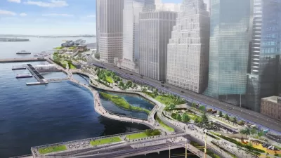
The Financial District and Seaport Climate Resilience Master Plan will extend the shoreline in Lower Manhattan by up to 200 feet.
Proposed Citywide Rezoning Would Layer Resilience in New York City
With 520 miles of coastline, New York City is ready to implement the lessons of Hurricane Sandy in the zoning code for the entire city.

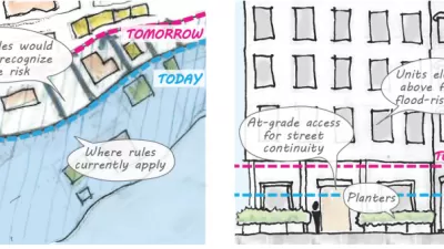
Managed Retreat in New York City
More and more New Yorkers will face the prospect of encroaching seas in the coming decades, and the unwanted choice of whether to stay or to go.

Maui's Vacation Rental Debate Turns Ugly
Verbal attacks, misinformation campaigns and fistfights plague a high-stakes debate to convert thousands of vacation rentals into long-term housing.

Planetizen Federal Action Tracker
A weekly monitor of how Trump’s orders and actions are impacting planners and planning in America.

Chicago’s Ghost Rails
Just beneath the surface of the modern city lie the remnants of its expansive early 20th-century streetcar system.

Bend, Oregon Zoning Reforms Prioritize Small-Scale Housing
The city altered its zoning code to allow multi-family housing and eliminated parking mandates citywide.

Amtrak Cutting Jobs, Funding to High-Speed Rail
The agency plans to cut 10 percent of its workforce and has confirmed it will not fund new high-speed rail projects.

LA Denies Basic Services to Unhoused Residents
The city has repeatedly failed to respond to requests for trash pickup at encampment sites, and eliminated a program that provided mobile showers and toilets.
Urban Design for Planners 1: Software Tools
This six-course series explores essential urban design concepts using open source software and equips planners with the tools they need to participate fully in the urban design process.
Planning for Universal Design
Learn the tools for implementing Universal Design in planning regulations.
planning NEXT
Appalachian Highlands Housing Partners
Mpact (founded as Rail~Volution)
City of Camden Redevelopment Agency
City of Astoria
City of Portland
City of Laramie