


Paris has made some incredibly ambitious and highly controversial policy changes to improve the city's air quality. In the meantime, there's a new app from Valeo to determine the state of the air quality in the city.
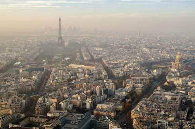
Jake Richardson shares news of a new app by Valeo that provides a real-time air quality map of the city of Paris, and could eventually navigates users around the areas with the worst air quality.
Valeo equipped 19 vehicles, 15 Keolis public transportation vehicles and four G7 Green taxis, with particle sensors. "Valeo’s sensors are designed to collect information on the concentration levels of various pollutants, including fine particles (PM 10 and PM 2.5), carbon monoxide, nitrogen dioxide, sulfur dioxide, and ozone," explains Richardson.
"Once recorded, these data points are fed into an instantaneous air quality index (AQI) map."
Eventually the app developers hope to allow navigation services that allow users to avoid areas in the city with the worst pollution.
FULL STORY: Real-Time Air Pollution Mapping In Paris Created By Valeo — #CleanTechnica Interview


Paris Bike Boom Leads to Steep Drop in Air Pollution
The French city’s air quality has improved dramatically in the past 20 years, coinciding with a growth in cycling.

New Google Map Layer Shows COVID-19 Infection Rates
A new layer showing the seven-day average of confirmed COVID-19 cases started rolling out to Android and iPhones last week.
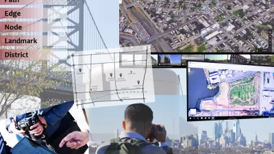
Analyzing Lynch's City Imageability in the Digital Age
Mahbubur Meenar of Rowan University writes about a recent article he co-authored in the Journal of Planning Education and Research

Planetizen Federal Action Tracker
A weekly monitor of how Trump’s orders and actions are impacting planners and planning in America.

Chicago’s Ghost Rails
Just beneath the surface of the modern city lie the remnants of its expansive early 20th-century streetcar system.

San Antonio and Austin are Fusing Into one Massive Megaregion
The region spanning the two central Texas cities is growing fast, posing challenges for local infrastructure and water supplies.

Since Zion's Shuttles Went Electric “The Smog is Gone”
Visitors to Zion National Park can enjoy the canyon via the nation’s first fully electric park shuttle system.

Trump Distributing DOT Safety Funds at 1/10 Rate of Biden
Funds for Safe Streets and other transportation safety and equity programs are being held up by administrative reviews and conflicts with the Trump administration’s priorities.

German Cities Subsidize Taxis for Women Amid Wave of Violence
Free or low-cost taxi rides can help women navigate cities more safely, but critics say the programs don't address the root causes of violence against women.
Urban Design for Planners 1: Software Tools
This six-course series explores essential urban design concepts using open source software and equips planners with the tools they need to participate fully in the urban design process.
Planning for Universal Design
Learn the tools for implementing Universal Design in planning regulations.
planning NEXT
Appalachian Highlands Housing Partners
Mpact (founded as Rail~Volution)
City of Camden Redevelopment Agency
City of Astoria
City of Portland
City of Laramie