


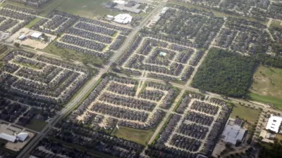
A decrease in affordable housing, the aftermath of Hurricane Harvey, and demographic changes mean more of the city’s neighborhoods are facing gentrification challenges.

A new report from the Kinder Institute for Urban Research at Rice University looks at neighborhoods in Houston that are facing the threat of gentrification or could in the future. These neighborhoods were identified through socioeconomic, housing, transportation, and location factors.
The study finds that gentrification is on the rise in Harris County, but it is distributed unevenly. Most gentrified neighborhoods are located outside of the 610 Loop. However, all neighborhoods on the east side of Houston within the loop are susceptible to future gentrification.
Communities have tried to rein in gentrification through policies including land use regulations, deed restrictions, and homestead exemptions as well as through land trusts and community engagement. "The researchers hope their work will not only shine a spotlight on the prevalence of gentrification and the problems it causes, but also help cities and communities think about how they can help low-income residents remain in their neighborhoods," reports Amy McCaig.
FULL STORY: Neighborhoods on Houston’s east side highly susceptible to gentrification

Houston’s Growth Poses Service Challenges
The Houston region continues to grow, and local regional governance is struggling to meet residents’ needs.

Surprising New Research on Gentrification in Houston
Affluent areas face more demolitions than gentrifying areas in Houston and Harris County, according to the findings of a new report from the Kinder Institute of Urban research.
A Housing and Eviction Crisis Still Hangs Over the U.S., Just Like the Pandemic
Checking in with the numerous risks in the housing market as the economic fallout of the pandemic as approaches it approaches its second year.

Planetizen Federal Action Tracker
A weekly monitor of how Trump’s orders and actions are impacting planners and planning in America.

Maui's Vacation Rental Debate Turns Ugly
Verbal attacks, misinformation campaigns and fistfights plague a high-stakes debate to convert thousands of vacation rentals into long-term housing.

Restaurant Patios Were a Pandemic Win — Why Were They so Hard to Keep?
Social distancing requirements and changes in travel patterns prompted cities to pilot new uses for street and sidewalk space. Then it got complicated.

In California Battle of Housing vs. Environment, Housing Just Won
A new state law significantly limits the power of CEQA, an environmental review law that served as a powerful tool for blocking new development.

Boulder Eliminates Parking Minimums Citywide
Officials estimate the cost of building a single underground parking space at up to $100,000.

Orange County, Florida Adopts Largest US “Sprawl Repair” Code
The ‘Orange Code’ seeks to rectify decades of sprawl-inducing, car-oriented development.
Urban Design for Planners 1: Software Tools
This six-course series explores essential urban design concepts using open source software and equips planners with the tools they need to participate fully in the urban design process.
Planning for Universal Design
Learn the tools for implementing Universal Design in planning regulations.
Heyer Gruel & Associates PA
JM Goldson LLC
Custer County Colorado
City of Camden Redevelopment Agency
City of Astoria
Transportation Research & Education Center (TREC) at Portland State University
Jefferson Parish Government
Camden Redevelopment Agency
City of Claremont