


Google subsidiary Sidewalk Labs has partnered with Waterfront Toronto to deploy smart city innovations in the redevelopment of the Quayside district along Toronto's Eastern Waterfront.
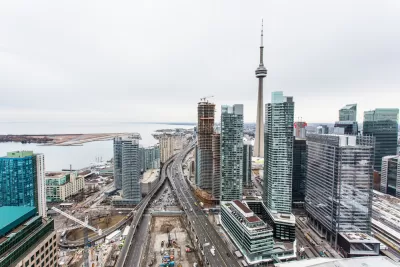
An interview with Rit Aggarwala, chief policy officer of Sidewalk Labs, delves into the company's experiment with smart city planning in Toronto's Quayside district.
Katherine A. Peinhardt writes a substantial introduction to the interview, writing for the Project for Public Space, so the discussion focuses on place, and technology's ability to rob places of charm. From the introduction:
But building great public spaces, more than any technology, requires a genuine focus on place. PPS has extensive experience in making places like waterfronts vibrant, people-centered places; keeping sight of local identity and prioritizing activity in a space are essential components of any successful project. If they are to take root, urban innovations — from autonomous vehicles to digital wayfinding — must keep these considerations and the community close at hand.
The interview starts with a discussion about the initial steps in Sidewalk Labs' process in Quayside before digging into what to expect from future steps in the process as well as from the technology that will eventually be deployed as redevelopment takes shape. Here's a sample of the discussion, as it focuses on the intersecting forces of real estate and transportation:
Q: How will the big plans for transportation outlined for Sidewalk Toronto support existing modes in the city, like the Subway and its streetcar?
A: Mobility is one of the areas where we have the potential to make a massive difference. It does hinge on an extension to existing modes of transit, as well as the creation of new forms of urban mobility. The fact is that none of what we hope for this site can be realized unless we get the existing transit system expanded into our site. You can’t create a successful urban neighborhood that has an entirely different transportation system. What we envision is a place where we can use both the power of overall real estate development and perhaps some innovative financing tools to work with the city, accelerating what the city already wants to do.
[Editor's note: the source article is from December—a bit dated by Planetizen standards but shared for its ongoing relevance to questions about the shape cities will take as "smart cities" technology evolves and takes shape in cities.]
FULL STORY: Google’s Urban Experiment in Toronto: A Q&A with Sidewalk Labs’ Rit Aggarwala

Tech and the Post-Pandemic City
To steer American cities into the future, public and private sectors—and citizens—must work together to build broad, lasting support around complicated issues such as transparency and data privacy.

Waterfront Toronto Greenlights Most of Sidewalk Labs' Quayside Master Plan
An evaluation committee made up of Waterfront Toronto staff has given a green light for the Sidewalk Labs master plan for Toronto to proceed to the next stages of planning.
Sidewalk Labs' 'Smart Cities' Experiment in Toronto Scaled Way Back
From 190 acres to 12 acres, that's the reduction in scale announced this week by representatives of Sidewalk Labs of its plan for Quayside on the waterfront in Toronto.

Maui's Vacation Rental Debate Turns Ugly
Verbal attacks, misinformation campaigns and fistfights plague a high-stakes debate to convert thousands of vacation rentals into long-term housing.

Planetizen Federal Action Tracker
A weekly monitor of how Trump’s orders and actions are impacting planners and planning in America.

In Urban Planning, AI Prompting Could be the New Design Thinking
Creativity has long been key to great urban design. What if we see AI as our new creative partner?

King County Supportive Housing Program Offers Hope for Unhoused Residents
The county is taking a ‘Housing First’ approach that prioritizes getting people into housing, then offering wraparound supportive services.

Researchers Use AI to Get Clearer Picture of US Housing
Analysts are using artificial intelligence to supercharge their research by allowing them to comb through data faster. Though these AI tools can be error prone, they save time and housing researchers are optimistic about the future.

Making Shared Micromobility More Inclusive
Cities and shared mobility system operators can do more to include people with disabilities in planning and operations, per a new report.
Urban Design for Planners 1: Software Tools
This six-course series explores essential urban design concepts using open source software and equips planners with the tools they need to participate fully in the urban design process.
Planning for Universal Design
Learn the tools for implementing Universal Design in planning regulations.
planning NEXT
Appalachian Highlands Housing Partners
Mpact (founded as Rail~Volution)
City of Camden Redevelopment Agency
City of Astoria
City of Portland
City of Laramie