


At the ninth session of the World Urban Forum held earlier in Kuala Lumpur, Malaysia, the Institute for Transportation and Development Policy introduced their new "Pedestrian First" toolkit to measure and promote walkability in urban environments.
When it comes to mobility, most American municipalities place priority on the movement of private motor vehicles. The needs of transit vehicles, cyclists and pedestrians are secondary. Kuala Lumpur, the site of the Ninth session of the World Urban Forum held from Feb. 7 to Feb. 13, is not much different.
"Organised by UN-HABITAT every two years in a different city around the world, this forum [was] the first session that focuse[d] on the implementation of the New Urban Agenda," noted one of the local organizers, Think City. The forum is considered the "world's premier conference on cities."
“Walkability is not just a sidewalk - it’s a whole system of design and infrastructure,” Joe Chestnut of the Institute for Transportation and Development Policy (ITDP), a global think tank, told the Thomson Reuters Foundation on the sidelines of the World Urban Forum in the Malaysian capital this month, reported Gregory Scruggs on Feb. 15.
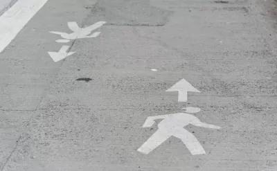
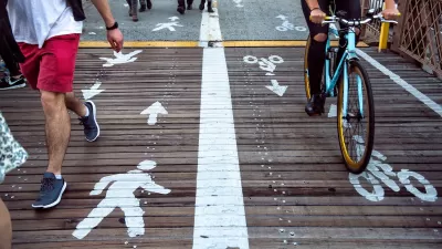
To help city officials tackle these challenges, Chestnut and his team designed a toolkit with 11 indicators for measuring how pedestrian-friendly a neighborhood is.
They include the number of pedestrian crossings, the size of blocks, the amount of shade and the density of driveways for cars.
Smaller blocks reduce walking distances and the need to make a dangerous mid-block crossing, as well as slowing down cars.
Scruggs compares some of the world's major cities to see how they rank in these walkability categories and also acknowledges two of the world's better recent developments that promote walkability.
On a busy street in downtown Kuala Lumpur, Chestnut pointed to pedestrian overpasses as infrastructure that appears to be designed for those who walk but more often inconveniences them while allowing cars to speed on through.
Kuala Lumpur is like any other big city,” said Neil Khor of Think City, a local government-backed urban regeneration agency. “It has a long way to go.”
Think City works with Malaysian cities to build pedestrian-friendly infrastructure, but Khor said the car still dominates.
Download the 75-page "Pedestrian First: Tools for a Walkable City." "With a better global understanding of walkability and more consistent and frequent measurement of the walkability of urban environments, decision-makers will be empowered to enact policies that create more walkable urban areas," according to ITDP.
“It is important that walkability isn’t a luxury (but) an essential component of equity and sustainability, particularly in the rapidly growing cities of the global south,” added Chestnut.
Hat tip to AASHTO Daily Transportation Update.
FULL STORY: How walkable is your city? Tool aims to make pedestrians safer and happier

Study: Americans Spending Less Time Interacting in Public Space
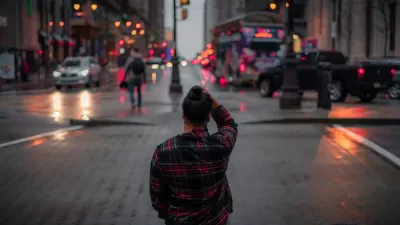
American pedestrians are moving faster and spending less time connecting with other people when walking down city streets.
When ‘Prioritizing All Modes’ Is a Lie
In many cases, it’s impossible to prioritize the safety of pedestrians and other vulnerable road users without sacrificing some speed.
Pedestrians First: Tools for a Walkable City
A comprehensive new website provides information on why and how to improve community walkability and offers practical tools for evaluating walking conditions.

Planetizen Federal Action Tracker
A weekly monitor of how Trump’s orders and actions are impacting planners and planning in America.

Maui's Vacation Rental Debate Turns Ugly
Verbal attacks, misinformation campaigns and fistfights plague a high-stakes debate to convert thousands of vacation rentals into long-term housing.

San Francisco Suspends Traffic Calming Amidst Record Deaths
Citing “a challenging fiscal landscape,” the city will cease the program on the heels of 42 traffic deaths, including 24 pedestrians.

Defunct Pittsburgh Power Plant to Become Residential Tower
A decommissioned steam heat plant will be redeveloped into almost 100 affordable housing units.

Trump Prompts Restructuring of Transportation Research Board in “Unprecedented Overreach”
The TRB has eliminated more than half of its committees including those focused on climate, equity, and cities.

Amtrak Rolls Out New Orleans to Alabama “Mardi Gras” Train
The new service will operate morning and evening departures between Mobile and New Orleans.
Urban Design for Planners 1: Software Tools
This six-course series explores essential urban design concepts using open source software and equips planners with the tools they need to participate fully in the urban design process.
Planning for Universal Design
Learn the tools for implementing Universal Design in planning regulations.
Heyer Gruel & Associates PA
JM Goldson LLC
Custer County Colorado
City of Camden Redevelopment Agency
City of Astoria
Transportation Research & Education Center (TREC) at Portland State University
Jefferson Parish Government
Camden Redevelopment Agency
City of Claremont