


SB 827, announced last week by California State Senator Scott Wiener, would revoke density maximums, parking minimums, and set permissive height limits along transit corridors all over the state.
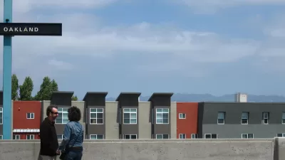
Sasha Aickin, former CTO of Redfin, spent the weekend mapping out the footprint of SB 827, proposed by California State Senator Scott Wiener last week. The informal mapping exercise, not official or sanctioned by Senator Wiener, provides a visualization of the broad reach of the proposed bill. In a written post that accompanies the new map, Aickin says "[n]early all of San Francisco would be set for upzoning to 85/55 foot heights, as would significant portions of Los Angeles, Long Beach, San Diego, Oakland, Berkeley, and Sacramento. More surpising [sic] to me, though, is the impact on smaller cities like Bakersfield, Santa Cruz, and San Bernardino, which also have a large amount of 85/55 foot upzoning."
Wiener agrees with the assessment of many on social media over the past week that the new bill represents an aggressive approach to the state's housing affordability crisis.
The bill is part of a package of bills designed as a "housing-first" policy for the state of California that would follow up on previous bills approved in 2017. Planetizen covered the new bills when Senator Wiener announced the package earlier this month.
FULL STORY: What would SB 827 really look like?


Aggressive New 'Housing-First Policy' Proposed in California State Legislature
California State Senator Scott Wiener has established himself as one of the most ardent supporters of pro-housing policy in the state. His announcement this morning continued the theme.

Interactive Mapping Tool Illustrates the Impact of California's Big Housing Bill
University of California, Berkeley researchers have mapped the impact of SB 50, a bill that would allow new density around train stations and bus stops in cities all over the state of California.

Amendments Proposed for California's Landmark Pro-Housing Development Legislation
Amendments are circulating for one of the most-closely watched, and passionately debated, pieces of housing legislation in the country.

Maui's Vacation Rental Debate Turns Ugly
Verbal attacks, misinformation campaigns and fistfights plague a high-stakes debate to convert thousands of vacation rentals into long-term housing.

Planetizen Federal Action Tracker
A weekly monitor of how Trump’s orders and actions are impacting planners and planning in America.

San Francisco Suspends Traffic Calming Amidst Record Deaths
Citing “a challenging fiscal landscape,” the city will cease the program on the heels of 42 traffic deaths, including 24 pedestrians.

Defunct Pittsburgh Power Plant to Become Residential Tower
A decommissioned steam heat plant will be redeveloped into almost 100 affordable housing units.

Trump Prompts Restructuring of Transportation Research Board in “Unprecedented Overreach”
The TRB has eliminated more than half of its committees including those focused on climate, equity, and cities.

Amtrak Rolls Out New Orleans to Alabama “Mardi Gras” Train
The new service will operate morning and evening departures between Mobile and New Orleans.
Urban Design for Planners 1: Software Tools
This six-course series explores essential urban design concepts using open source software and equips planners with the tools they need to participate fully in the urban design process.
Planning for Universal Design
Learn the tools for implementing Universal Design in planning regulations.
Heyer Gruel & Associates PA
JM Goldson LLC
Custer County Colorado
City of Camden Redevelopment Agency
City of Astoria
Transportation Research & Education Center (TREC) at Portland State University
Jefferson Parish Government
Camden Redevelopment Agency
City of Claremont