


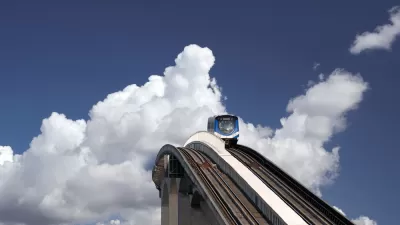
Vancouver shows how to retrofit suburban sprawl with transit and density at a recent Lambda Alpha International event, attended and recounted by development consultant Jim Chappell.
At the September 2017 Land Economics weekend in Vancouver put on by Lambda Alpha International (LAI), Jim Chappell, a former San Francisco Planning and Urban Research Association Executive Director and a development consultant, was impressed enough by to write about it. Like other metropolitan areas that acquired their urban form in the post WWII auto-oriented, the Vancouver metropolitan area had become a sprawling auto-dependent suburbia. However, "Metro Vancouver"—"a federation of 23 jurisdictions"—is well ahead of most other sprawling metropolitan areas in converting into a form that addresses the needs for more equitable and sustainable transit and housing.
The Regional Growth Strategy was updated and adopted by Metro and all 23 jurisdictions in 2012 and extends to 2040. It is a plan for a network of 26 urban nodes ranging in size and character and connected by SkyTrain and other rail connections. There are a planned nine “regional city centers” and 17 smaller regional-scaled activity hubs.
Metro area cities and neighborhoods like Burnaby, Surrey, Brentwood, and Lougheed, are experiencing impressive densification along these SkyTrain transit nodes, with residential buildings up to 600 feet in height. Chappell goes into more detail in the source article.
FULL STORY: How Metropolitan Vancouver Is Reorganizing Suburban Growth Around Transit

Displacement Concerns Grow Along With Residential Developments in Vancouver
In its efforts to build a more environmentally sustainable region by prioritizing transit and transit-oriented development, cities in the Vancouver region also create displacement risks for people who already use and depend on transit.
TOD Around Vancouver's New Rapid Transit, But What Kind?
As a planned rapid transit line gets closer to completion in Vancouver, there's a debate brewing about what sort of development should spring up around it.

Braille Signage Now at All Vancouver Bus Stops
The city completed installation of signage for people with visual impairments at over 8,000 bus stops.

Planetizen Federal Action Tracker
A weekly monitor of how Trump’s orders and actions are impacting planners and planning in America.

Map: Where Senate Republicans Want to Sell Your Public Lands
For public land advocates, the Senate Republicans’ proposal to sell millions of acres of public land in the West is “the biggest fight of their careers.”

Restaurant Patios Were a Pandemic Win — Why Were They so Hard to Keep?
Social distancing requirements and changes in travel patterns prompted cities to pilot new uses for street and sidewalk space. Then it got complicated.

Platform Pilsner: Vancouver Transit Agency Releases... a Beer?
TransLink will receive a portion of every sale of the four-pack.

Toronto Weighs Cheaper Transit, Parking Hikes for Major Events
Special event rates would take effect during large festivals, sports games and concerts to ‘discourage driving, manage congestion and free up space for transit.”

Berlin to Consider Car-Free Zone Larger Than Manhattan
The area bound by the 22-mile Ringbahn would still allow 12 uses of a private automobile per year per person, and several other exemptions.
Urban Design for Planners 1: Software Tools
This six-course series explores essential urban design concepts using open source software and equips planners with the tools they need to participate fully in the urban design process.
Planning for Universal Design
Learn the tools for implementing Universal Design in planning regulations.
Heyer Gruel & Associates PA
JM Goldson LLC
Custer County Colorado
City of Camden Redevelopment Agency
City of Astoria
Transportation Research & Education Center (TREC) at Portland State University
Camden Redevelopment Agency
City of Claremont
Municipality of Princeton (NJ)