


The adaptive nature of cities is exemplified once again, by the self-organizing response of street networks after transformative changes.
In a preceding article, I argued that a "city-as-an-artifact" approach to planning misses the organic nature of cities, and, when used in action, the approach could result in disappointing, if well-intended, outcomes. Similarly, biomorphic models for cities fail to construct a unified, actionable theory of planning.
The previous article pointed to the universal constancy of trip-to-work time [pdf] as a clear example of a city's self-organizing, adaptive nature, which produces robust outcomes without top-down intervention—a key identifier of an "organic whole." We also alluded to the possibility of more examples a city's self-organizing, adaptive nature. This article will examine a second example—the robustness of a city's road network composition.
Self-Organizing Systems
Referring to the World Wide Web, N. Salingaros writes: "None of this structure has been imposed -- it has all grown incrementally. Here we have an excellent example of self-organization, the process by which forces manage to act in balance to grow a complex system into a stable working structure."
Similarly, while individual roads are normally built to a plan, their collective assembly into a network is retrospectively observed in totality, but never conceived as such—partly because networks grow piecemeal, often in unpredictable ways, and partly because of their time scale, often many decades long. In addition, parts of large Census metropolitan areas fall under separate jurisdictions. The outcome of all these separate influences resembles a patchwork rather that a neatly woven fabric. Each new addition to the system not only becomes context for the subsequent one, but is also conditioned by factors that emerge in the long interim—new modes of transportation, for example (i.e., a process analogous to morphogenesis). Moreover, once built, road systems may undergo changes that alter their composition either through gradual transformation or drastic intervention, as in the case of 19th century Paris.
Given the sporadic, disjointed manner in which road networks are built, grow, and mutate, it might be expected that the outcome would be disorganized, even chaotic, as cities themselves frequently appear to be. Could there be hidden order in the apparent messiness?
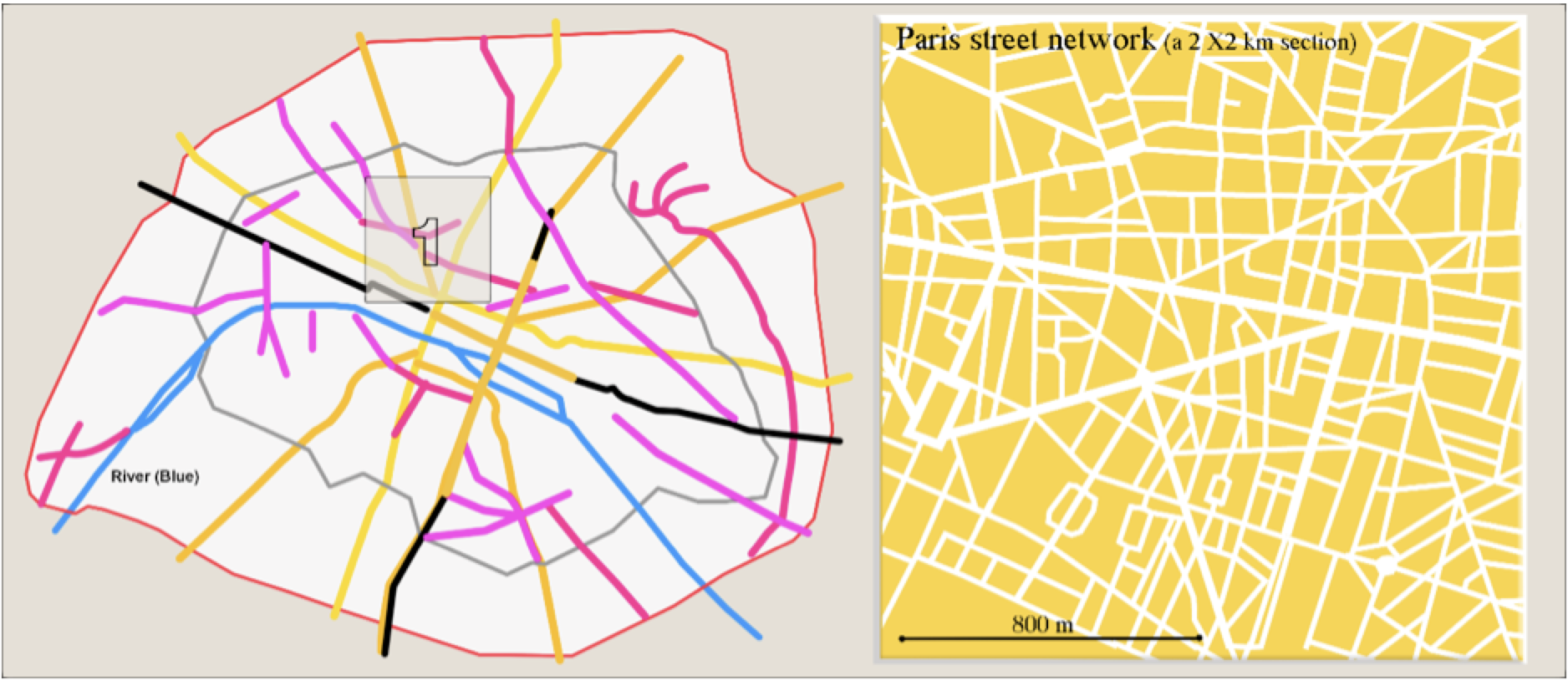
What Data Show
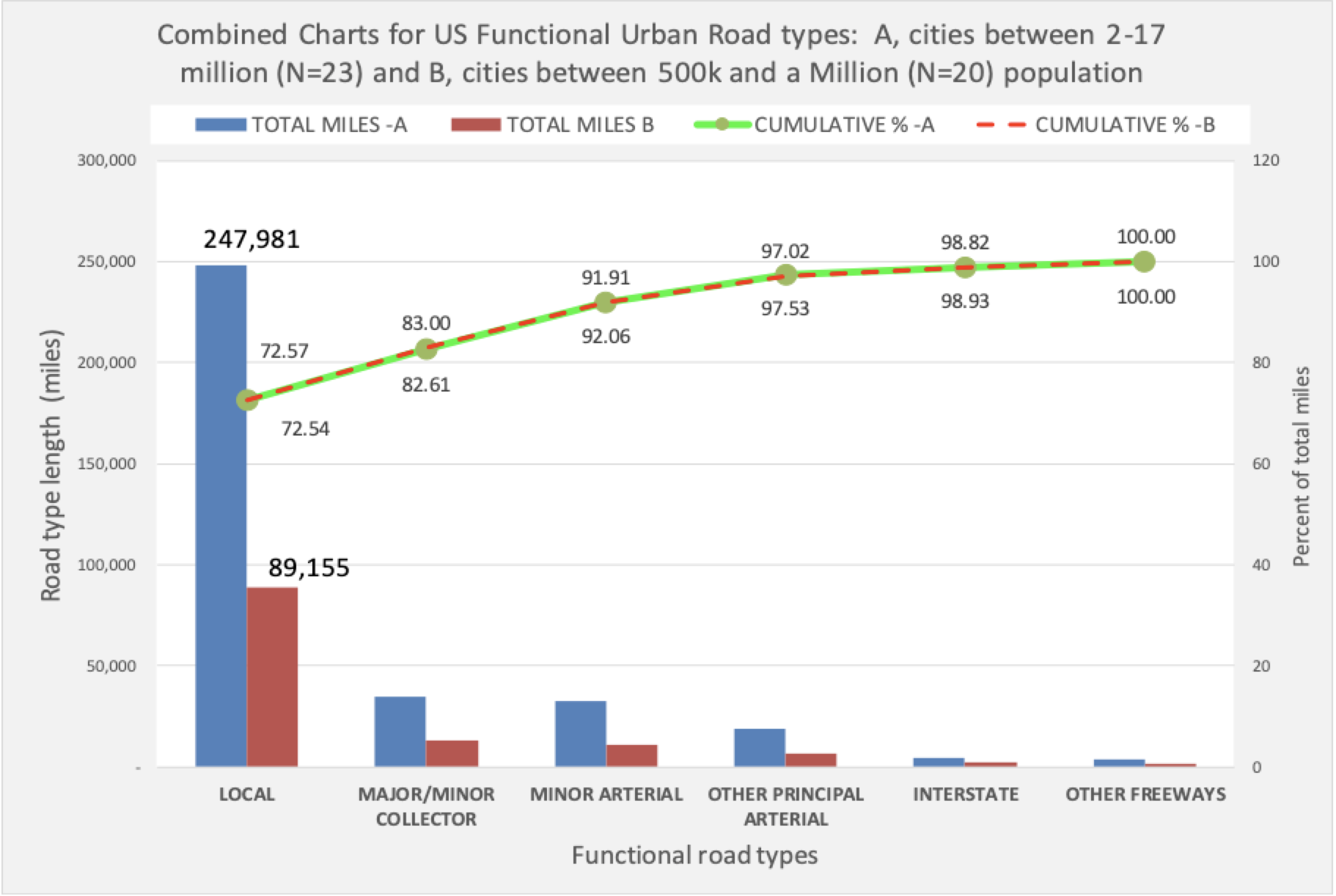
Figure 1 unequivocally answers the question of a robust order. Though the network size of one group is a multiple of the other, the ratios of their constituent parts are virtually identical (as shown by the overlapping green and red line). These two groups contain cities that vary in age and geographic settings as well as to their populations, area, and densities. In spite of these differences, it seems that their road network systems maintain an invariable composition.
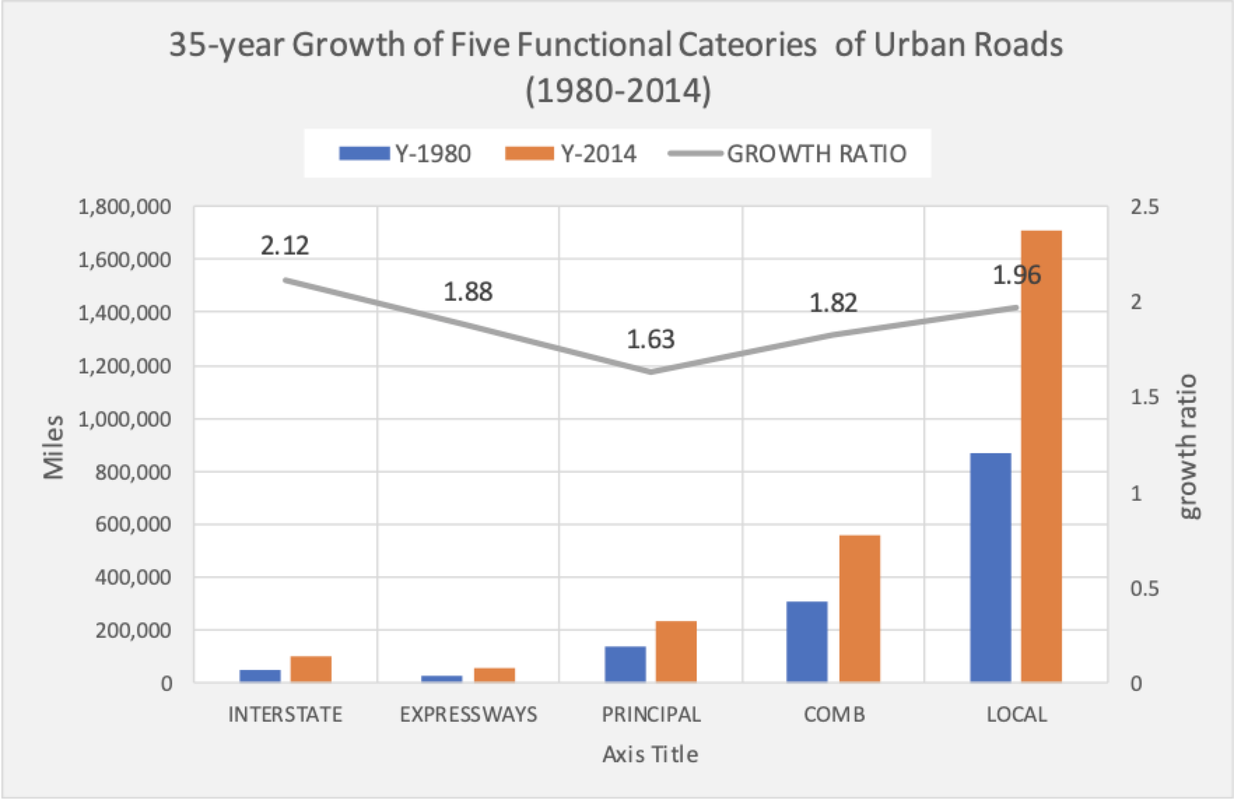
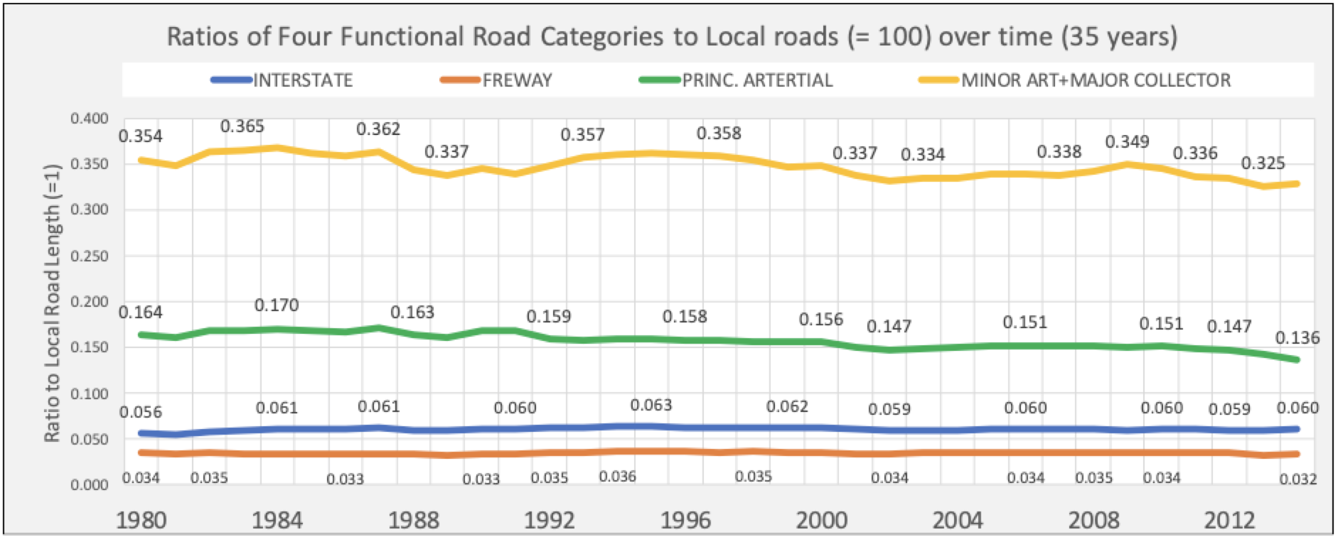
This invariable composition is true also in spite of substantial growth; in the 35 years between 1980 and 2014. (Fig. 2) they have almost doubled. It might be expected that growth might have introduced fluctuations in the network structure. As figure 3 shows, however, throughout this entire period the ratios between the constituent components of the networks have remained remarkably stable.
Change and Stability
Existing city road networks regularly experience transformations—often minor, but also, infrequently, major. Examples of minor changes include the re-designation of residential roads into collectors or arterials, usually followed by selectively limiting access to the road by means of closures of intersecting streets or forced turns. Such changes on occasion necessitate widening of the pavement and adding a lane. Strategic local streets occasionally become de facto collectors or arterials by being designated for one-way traffic or by providing ramp access to a highway. Another common example of street transformation is pedestrianization, which removes a street from the vehicular network. Many more incremental changes occur over time—too many to mention individually. It is unknown whether such changes significantly affect the calculus of a system's components given their incidental nature and their likely limited cumulative length.
Examples of major transformations at key historical points, as a result of exponential city growth, political upheavals, wars, or new transport means are limited but non-trivial. The sack of Miletus, a military event in 494 BC, gave birth to the Hippodamian grid. More recently, in the 19th century, a drastic transformation occurred in Paris, one that achieved iconic status and has been studied extensively ever since.
Paris, Haussmann, and Network Composition
The 19th century Paris experienced frequent revolts, rebellions, and uprisings, as well as consequent changes in government. Concurrently, it also became France's main industrial and commercial center. Around the 20 years of Haussmann's tenure as a prefect (Fig 4), Paris doubled population, from nearly a million in 1850 to two million in 1870. This growth brought enormous pressures for change and adaptation on many fronts: social, political, institutional, economic, and, inevitably, infrastructural. Salingaros writes: "As it grows, a city requires larger and larger roads. A network is always driven to adjust its communication infrastructure towards and inverse power HIERARCHY. This is the reason why the mediaeval city -- with short-range pedestrian connections -- could not survive unchanged." In this 1860s case, the infrastructure is streets, as existed in a century when the foot and the hoof were the predominant modes of transportation.
Two studies examined the impact of Haussmann's extraordinary and disruptive intervention. The first studied the changed composition of the road network and the second studied the rationale of Haussmann's changes. The "[…] self-organized evolutionof roads seems in general to be local in space, [while by contrast] the Haussmann modifications happen during a relatively short time and at a large spatial scale by connecting important nodes which are far away in the network" argues Mark Barthelemy in "Self-organization versus top-down planning in the evolution of a city." These changes might have replaced the missing links that unite distinct, self-contained neighbourhoods into a new composite, functioning whole—the coalescing of "villages."
The modified Parisian network and its new organic hierarchy are shown through a chart of total street length by street width range. (Fig. 5)
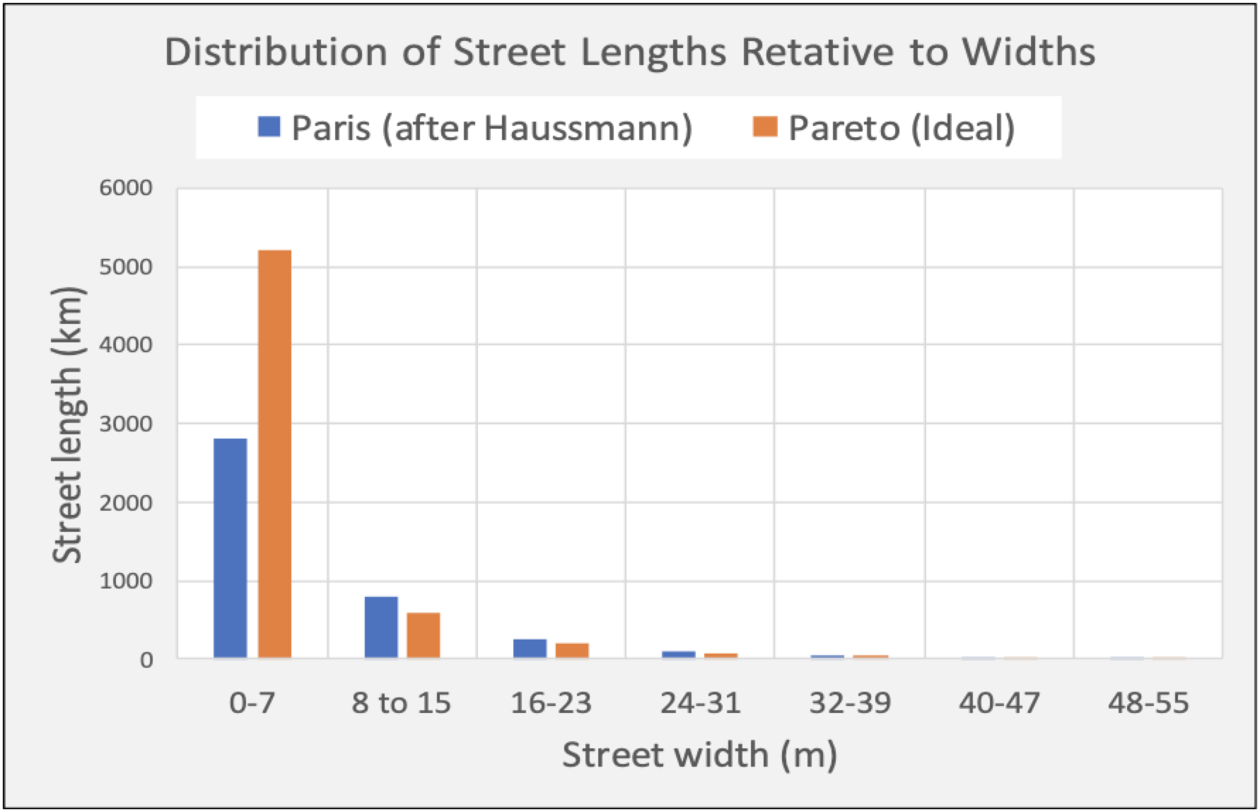
Of the many diverse, well documented motives for the extensive transformation of Paris' network, the restructuring of its network composition was not one of them; it was a coincidental, collateral outcome. Barthelemy writes that "[..]It is unclear at this stage if Haussmann's modifications were optimal and more importantly, if they were at a certain point inevitable and would have happened anyway (due to the high level of congestion for example)." Barthelemy also speculates: "The evolution of a city thus seems to result from the superimposition of continuous, local growth processes and punctuated changes operating at large spatial scales." Many old European capitals seem to have flourished without an expansive, Haussmanian surgery, instead undergoing slow, evolutionary adaptations.
The Road Ahead
This piece revealed the constancy of the distribution of road types primarily among U.S. cities over a lengthy period. This distribution inevitably reflects the multiple motorized modes that emerged in, and characterize, the 20th century, that were entirely absent in the 19th century. One might ask whether this distribution is the "correct" one for the current transportation needs. The answer can only be speculative: Not necessarily, but neither, arguably, very unlikely. If this distribution is seen as a product of organic evolution it must, in principle, serve its purpose satisfactorily or it would have been coerced into a different distribution. For now, we can only consider it as a robust outcome of a complex system. Assuming that it may somehow be found not ideal, would a Haussmann-type intervention be a proper response or the slow, bottom-up "organic" reconstitution? That's an open planning question.
This short excursion into the composition of current urban road networks confirms the possibility that road networks are one of the robust, invariant outcomes of a self-organizing system—the city. But unlike the extensive geographic and temporal research that led to the indisputable confirmation of the travel-to-work time constant in my previous article, this limited effort leaves substantial ground to be covered. For the time being, it adds another piece of evidence that cities are complex, "organic wholes," and can be studied as such. It also raises once more the question of the precise role of planning in the evolution of cities.
Fanis Grammenos is the director of Urban Pattern Associates in Ottawa, Ontario and the author of Remaking the City Grid: A Model for Urban and Suburban Development (i.e., the Fused Grid). Reach him by email with questions or comments.

Is This Urbanism?
Chuck Wolfe ponders a recommended subscription list of Substack urbanists and wonders — as have others — about the utility of the "urbanist" moniker.

Survey: US Public Spaces Not Meeting Community Needs
A lack of funding prevents many U.S. parks and public spaces from playing a more significant role in helping residents meet daily needs.
Is the Urban Form Sustainable?
One author offers a framework for resilience that rethinks common assumptions about the inevitability of cities as we know them.

Planetizen Federal Action Tracker
A weekly monitor of how Trump’s orders and actions are impacting planners and planning in America.

Maui's Vacation Rental Debate Turns Ugly
Verbal attacks, misinformation campaigns and fistfights plague a high-stakes debate to convert thousands of vacation rentals into long-term housing.

San Francisco Suspends Traffic Calming Amidst Record Deaths
Citing “a challenging fiscal landscape,” the city will cease the program on the heels of 42 traffic deaths, including 24 pedestrians.

Defunct Pittsburgh Power Plant to Become Residential Tower
A decommissioned steam heat plant will be redeveloped into almost 100 affordable housing units.

Trump Prompts Restructuring of Transportation Research Board in “Unprecedented Overreach”
The TRB has eliminated more than half of its committees including those focused on climate, equity, and cities.

Amtrak Rolls Out New Orleans to Alabama “Mardi Gras” Train
The new service will operate morning and evening departures between Mobile and New Orleans.
Urban Design for Planners 1: Software Tools
This six-course series explores essential urban design concepts using open source software and equips planners with the tools they need to participate fully in the urban design process.
Planning for Universal Design
Learn the tools for implementing Universal Design in planning regulations.
Heyer Gruel & Associates PA
JM Goldson LLC
Custer County Colorado
City of Camden Redevelopment Agency
City of Astoria
Transportation Research & Education Center (TREC) at Portland State University
Jefferson Parish Government
Camden Redevelopment Agency
City of Claremont