


For my annual update of the apps that support planning I've compiled a list of the latest applications for sharing information, visualizations, sensing, predicting, supporting decision making, crowdsourcing, and engaging.

Today I gave a presentation called “Mobile Planning: There’s an App For That” for the American Planning Association’s Chapters and Divisions Webcast series. More than 400 planners across the US participated. This is part of my annual update of the latest apps that support planning. In the coming days a video version of the presentation will be available at http://www.youtube.com/user/PlanningWebcast
Each year I provide an update on mobile applications. Some of you may have read my previous report last fall on Planetizen. For 2013, there is a lot to share. The growth in mobile apps is amazing and increasingly they are supporting the things we do as planners. If you have apps that should be added to my growing list for 2013, please let me know. I also regularly tweet about new apps that I learn about. You can follow me @EvansCowley.
The most basic of apps are those that share information. This is a simple way for planners to share information with users and for us as planners to obtain information that is helpful to us in our professional positions. This includes apps like:
America’s Economy: This app provides Census Bureau and Bureau of Labor Statistics information at the national and regional level for the leading economic indicators. Available for iPhone and Android.
Sitegeist: This app detects your location and then provides a variety of interesting pieces of data about the neighborhood, ranging from Census demographics, to popular FourSquare checkin locations. Available for iPhone and Android.
Singapore MasterPlan 2008: This is the only city I know of that has their land use master plan in the form of an app. It provides information on permitted land uses and densities for development throughout Singapore. Available for iPhone.
GNOi: The Greater New Orleans economic development agency provides information on economic development incentives for jurisdictions throughout the region. Available for iPhone.
PlanningVic: Victoria, Australia provide an app that allows users to enter an address and they will be emailed a planning report including information such as zoning, lot descriptions and other useful land use information. Available for iPhone.
A handful take information sharing to another level providing attractive graphics and flythroughs.
Stats of the Union: This app beautiful provides health care statistics at the county level for the entire United States. Available for iPhone and iPad.
Bay Bridge Explorer: This visualization app allows you to fly through and see the San Francisco Bay Bridge project in sigificant detail. Available for iPhone and iPad.
Sensing is becoming embedded in all kinds of apps. Sensing everything from your location, vibration, to noise levels.
WalkSafe: Android app that sense is a car is coming towards you while you are walking.
StreetBump: Collects data on potholes in the City of Boston while you are driving. Available for iPhone.
Hit the Pothole:Collects data on potholes while driving or bicycling for a number of cities. Available for iPhone.
The next big wave that I see coming are predictive apps. These are apps that forecast conditions based on historic and real time data.
Tiramisu: Provides real time and historic data on bus arrivals and number of seats on public transit in Pittsburgh. Available for iPhone.
CycleTracks: San Francisco County collects data from users about their routes, destinations, and purpose of cycling trips. This is used in the transportation modeling for the county. Available for iPhone.
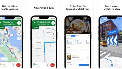
Inrix: Never Be Late Again: Uses real time and historic data to provide alternative routes, estimated arrival times and locations of accidents and construction. Available for Android, iPhone and iPad.
Then there are apps that are designed to help support decision making. The Inrix app is an example of one that is both predictive and intended to help support decision making.
SF Park: Allows users to find the location, pricing and availability of public parking in San Francisco. Available for iPhone.
ParkPGH: Users can find information about the location and availability of spaces in parking garages in Pittsburgh. Available for iPhone.
Zoner: Provides information on the zoning of property in New York City. Available for Android.
Then there are the maps that encourage users to participate in crowdsourcing information.
ParkCirca: Allows users to find private parking spaces available for a fee in major cities. Available for iPhone, Android, and Windows.
OpenTreeMap: Used in San Diego, Philadelphia and Grand Rapids. Open format allows other cities to use this app. Available for iPhone.
Some of my favorite apps are those that engage. Visit Baltimore: Augmented reality allows users to find out about sites in any direction. Available for iPhone.
Participants in the webcast shared a host of apps that they found useful as well. This includes:
Car2Go: Find where you can share a car. Available for iPhone and Android.
Capital Bikeshare: Find where bikesharing stations are in Washington DC. Available for iPhone.
MetroPulse: The Chicago Metropolitan Planning Agency developed this app that shares regional metrics that support planning. Available for iPhone.
Zillow: A real estate app available nationwide available for all mobile device types.
CycleAtlanta and CycleTracks Austin are two examples of bicycling apps that support transportation planning. And several participants were interested and shared mobile apps for art walks, including in Sacramento, Columbus, and New York, and Surrey. In Burlington, Vermont an augmented reality app is underdevelopment that will provide historic information on buildings throughout the downtown.
We talked about sources of funding for apps. This included funding from the Federal Highway Administration for congestion apps. The FAA has hosted apps competitions. And of course many cities have hosted their own apps competitions.
Participants expressed a strong interest in learning more about apps that can be used to engage the public. Code for America has an Engagement Commons that includes links to apps such as SeeClickFix.
For those interested in learning more, I'm offering a free online course called TechniCity this May. You can learn more about this course at my previous blog post on TechniCity.


The Best Planning Apps for 2014
We have compiled a list of mobile apps to support planning, as part of our annual update. Learn about exciting new ways to explore cities and enhance planning via mobile apps. Please feel free to add your own favorites.
Recommended Mobile Apps for Urban Planning in 2023
Planetizen's annual list of top apps for planners is back, ten years after its first appearance on the site. Scores of apps have been recommended by planners as examples of planning in action, or tools for planning action.
Best Apps for Urban Planning in 2022
Mobile apps continue to redefine the practices of planning—urban planning, regional planning, transportation planning, community planning, and rural planning included.

Planetizen Federal Action Tracker
A weekly monitor of how Trump’s orders and actions are impacting planners and planning in America.

Maui's Vacation Rental Debate Turns Ugly
Verbal attacks, misinformation campaigns and fistfights plague a high-stakes debate to convert thousands of vacation rentals into long-term housing.

Restaurant Patios Were a Pandemic Win — Why Were They so Hard to Keep?
Social distancing requirements and changes in travel patterns prompted cities to pilot new uses for street and sidewalk space. Then it got complicated.

In California Battle of Housing vs. Environment, Housing Just Won
A new state law significantly limits the power of CEQA, an environmental review law that served as a powerful tool for blocking new development.

Boulder Eliminates Parking Minimums Citywide
Officials estimate the cost of building a single underground parking space at up to $100,000.

Orange County, Florida Adopts Largest US “Sprawl Repair” Code
The ‘Orange Code’ seeks to rectify decades of sprawl-inducing, car-oriented development.
Urban Design for Planners 1: Software Tools
This six-course series explores essential urban design concepts using open source software and equips planners with the tools they need to participate fully in the urban design process.
Planning for Universal Design
Learn the tools for implementing Universal Design in planning regulations.
Heyer Gruel & Associates PA
JM Goldson LLC
Custer County Colorado
City of Camden Redevelopment Agency
City of Astoria
Transportation Research & Education Center (TREC) at Portland State University
Jefferson Parish Government
Camden Redevelopment Agency
City of Claremont