


How a small plaza in Cranford, New Jersey became a community beacon.
This blog post is republished with permission from NJ Urbanthinker.
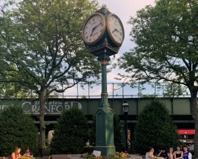
Every public space holds a story—how it was created, designed, its intended purpose, and its role within the community. This is the story of Eastman Clock Plaza, commonly known as "The Clock," located in the heart of Downtown Cranford.
To understand the history of Eastman Clock Plaza, we must first look at the history of Downtown Cranford and the structures and layouts that remain today. The development of Cranford’s downtown can be traced back to one pivotal event: the arrival of the railroad. In the mid-1850s, the Central Railroad of New Jersey constructed a line through Cranford, connecting the town to Newark and New York City. This new transportation link became the driving force behind the growth of Downtown Cranford.
How does the growth of downtown Cranford lay the foundation for Eastman Clock Plaza? Fortunately, a wealth of resources exists to help uncover this history. In the 2000s, Princeton University undertook a significant project to offer insights into the historical built environment of various municipalities by digitizing historical Sanborn maps across New Jersey.
What is a Sanborn map? Produced by the Sanborn Map Company, these maps provide detailed information about a building's footprint and usage. Originally created for fire insurance purposes, their production declined as insurance companies stopped using them in the 1960s, with the last maps produced in 1977. Fortunately for historical urban geographers like myself, Princeton University digitized Sanborn maps for Downtown Cranford from 1893, 1903, 1908, 1915, and 1922.
In addition to these maps, I reached out to Bernie Wagenblast, where she provided me with several historical photos of the area where Eastman Clock Plaza stands today. I also posted on the Cranford Talks Facebook page, asking if anyone had historical images of the plaza, and Captain Joseph Van Bergen of Cranford’s Police Department shared several valuable pictures. Lastly, I submitted an Open Public Records Act (OPRA) request to the Downtown Management Corporation (also known as Downtown Cranford), and they provided me with a document that I will discuss later.
Sanborn Map research
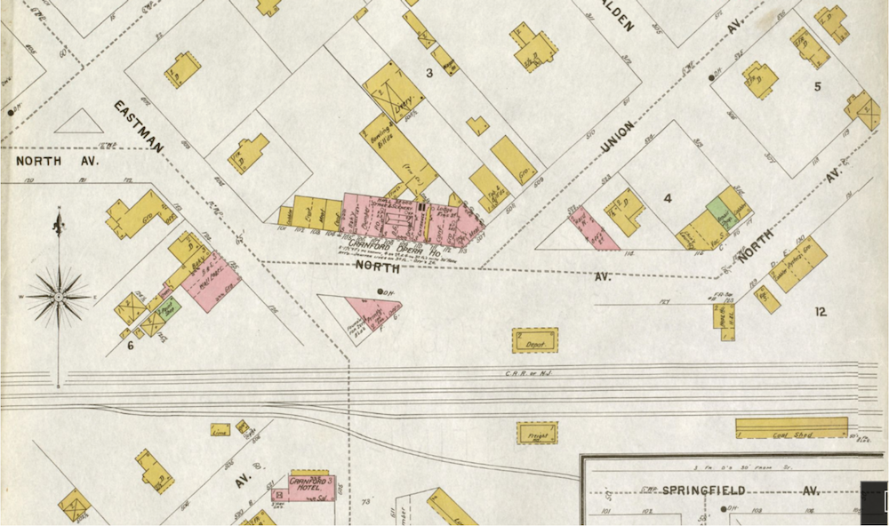
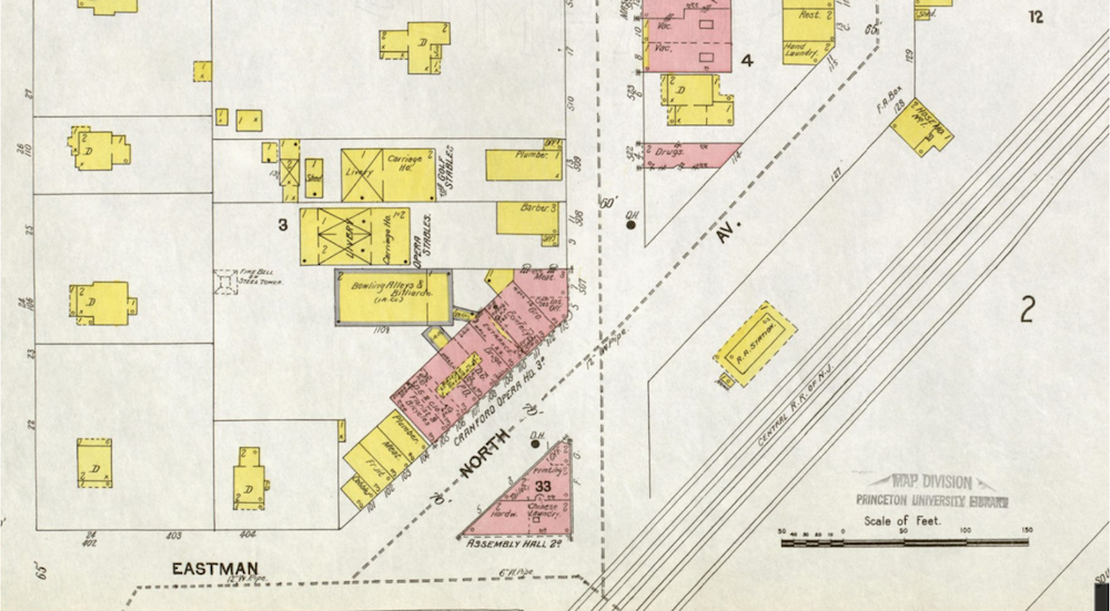
Let’s explore what was historically located at the site of Eastman Clock Plaza according to the Sanborn maps. Downtown Cranford was divided by the train line, with Union Avenue ending at the train station in both directions. In 1893, there were only scattered buildings in the downtown area, but the early development of Cranford’s building footprint was already underway. Notably, the Cranford Opera House stood on North Avenue—a cultural landmark designed by prominent Cranford architect Frank Lent in 1892. It hosted musical performances, operas, and public events, making it a vibrant center of the community. Unfortunately, the Opera House burned down in 1912, but it was later replaced by the Cranford Trust building, which still stands in downtown today.
As for the area where Eastman Clock Plaza is now located, the Sanborn maps show it as vacant, with no structures present at the time.
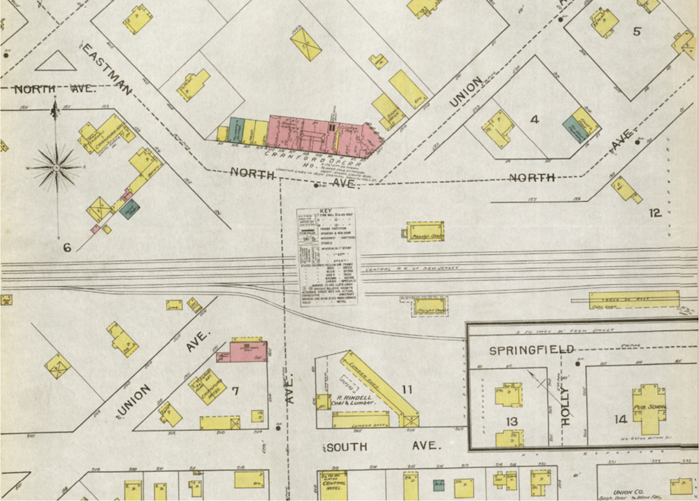
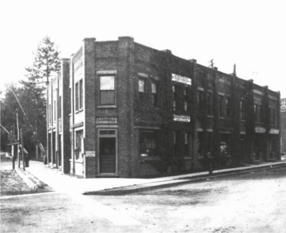
Let's take a look at the 1898 Sanborn map. At that time, there was a building situated in what is now Eastman Clock Plaza. The Sanborn maps are incredibly detailed, even indicating the specific functions of buildings. In 1898, this particular building housed a printing company. According to Captain Van Bergen, the structure is commonly referred to as the Potter Building or the Chronicle Building.
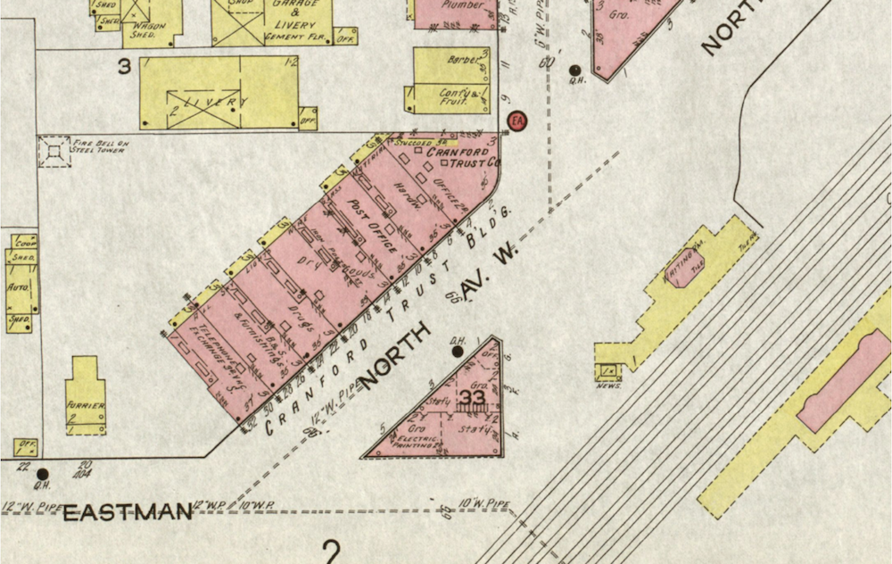
In 1903, the building known as the Potter or Chronicle Building was still present, and it housed five different businesses: a printing company, an office, a Chinese laundry, a hardware store, and a tailor. Interestingly, the map also included the label "Assembly Hall" under the building, though its meaning is unclear. By 1908, the businesses had changed slightly, with the building now home to a cigar shop, printing company, tailor, hardware store (specializing in paints and oils), and a Chinese laundry. As with the previous map, "Assembly Hall" was mentioned again, along with a new note, "to be offices."
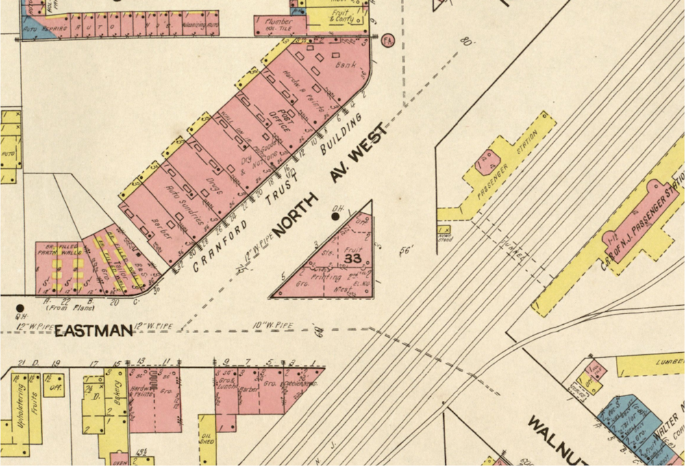
In 1915, the building continued to have five uses, including abbreviations "Gro" and "Staty." After consulting a resource from MIT on Sanborn map acronyms, it became clear that "Gro" stood for grocery and "Staty" for stationery. Notably, one of the stationery businesses also had an electric printing function, which may explain the building’s association with the name "Chronicle Building," likely due to the printing of publications. By 1922, the building still housed five businesses, but now one was listed as "Fruit" and another as "Meat," which makes it easy to deduce there were both a fruit and a meat shop in the building.
Historical picture research
Now, let's dive into historical photographs to explore the story of Eastman Clock Plaza. I’d like to extend my gratitude to Bernie Wagenblast and Captain Joseph Van Bergen of the Cranford Police Department for their invaluable historical research and for providing the images that allow us to delve into the rich history of Eastman Clock Plaza.
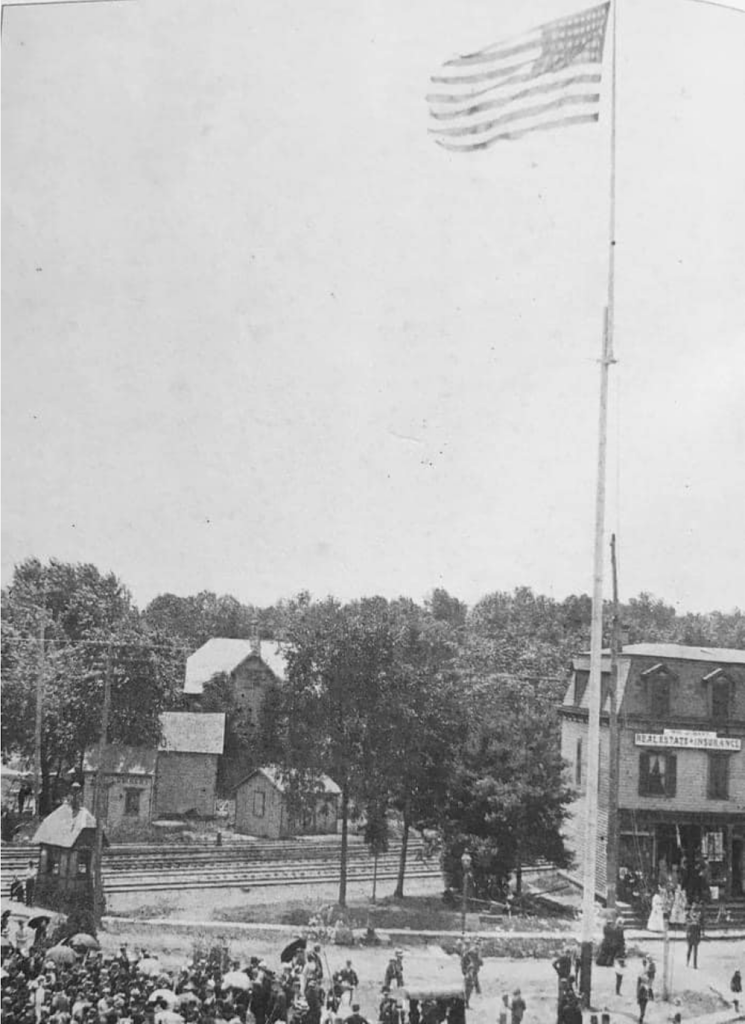
The first photo, taken in 1891, captures a flag-raising event. The flag's location is roughly where Eastman Clock Plaza stands today. This image dates back to a time before motor vehicles became widespread and transformed both urban and suburban landscapes.
The next photo, from 1924, shows how the rise of motor vehicles reshaped Downtown Cranford. The image is taken from approximately where Track 5 is today, offering a view of the Cranford Trust Building along North Avenue, with cars parked along North Avenue and Eastman Street. Interestingly, the area where Eastman Clock Plaza now stands is an undeveloped green space at this time.
Fast forward to the 1940s, and that green space has evolved. It’s now separated by curbing, and the parking spots on North Avenue are angled—much like they are today. The same angled layout is also seen for parking on Eastman Street. This marks the early transformation of the Eastman Clock Plaza area into a parking lot.
The next photo, from around the 1970s, shows that the parking layout remains the same as it was in the 1940s. However, by the 1970s, two benches and some greenery had been added. Despite these small changes, the area that is now Eastman Clock Plaza continued to serve as a parking lot, remaining largely unchanged until the developments described below.

A Fight For the Future of People's Park
Community groups are fighting a plan to build student housing in the historic People's Park.
Operation Neighborhood Recovery
Shelterforce magazine takes a look at one of the hardest hit areas in New Jersey by the ongoing foreclosure crisis, and a first-in-the-nation property acquisition project that aims to stabilize neighborhood in decline.

How Public Spaces Exclude Teen Girls
Adolescent girls face unique challenges and concerns when navigating public spaces. We can design cities with their needs in mind.

Planetizen Federal Action Tracker
A weekly monitor of how Trump’s orders and actions are impacting planners and planning in America.

Restaurant Patios Were a Pandemic Win — Why Were They so Hard to Keep?
Social distancing requirements and changes in travel patterns prompted cities to pilot new uses for street and sidewalk space. Then it got complicated.

Map: Where Senate Republicans Want to Sell Your Public Lands
For public land advocates, the Senate Republicans’ proposal to sell millions of acres of public land in the West is “the biggest fight of their careers.”

Maui's Vacation Rental Debate Turns Ugly
Verbal attacks, misinformation campaigns and fistfights plague a high-stakes debate to convert thousands of vacation rentals into long-term housing.

San Francisco Suspends Traffic Calming Amidst Record Deaths
Citing “a challenging fiscal landscape,” the city will cease the program on the heels of 42 traffic deaths, including 24 pedestrians.

California Homeless Arrests, Citations Spike After Ruling
An investigation reveals that anti-homeless actions increased up to 500% after Grants Pass v. Johnson — even in cities claiming no policy change.
Urban Design for Planners 1: Software Tools
This six-course series explores essential urban design concepts using open source software and equips planners with the tools they need to participate fully in the urban design process.
Planning for Universal Design
Learn the tools for implementing Universal Design in planning regulations.
Heyer Gruel & Associates PA
JM Goldson LLC
Custer County Colorado
City of Camden Redevelopment Agency
City of Astoria
Transportation Research & Education Center (TREC) at Portland State University
Camden Redevelopment Agency
City of Claremont
Municipality of Princeton (NJ)