


This is part one in a blog series examining the history of public lands in the United States and their shifting role in the American psyche.


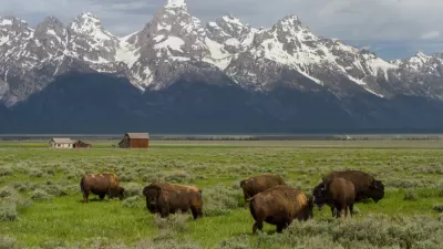
For much of U.S. history, the concept of public lands and the extensive network of U.S. national parks have been praised as the nation’s ‘best idea.’ But how much land the federal government should own and what uses should be allowed on it are persistently up for debate. This series will outline the origin of publicly held land in the United States, the various ways it has been exploited and protected, and the movements that have shaped how we view land and natural resources today—with the acknowledgement that “public” is a fraught term that has not historically included everyone. As climate change exacerbates extreme weather events, resources like water become strained and extractive industries come into conflict with conservation goals, and population growth prompts more urban development, the problem of balancing land uses such as housing and conservation only becomes more urgent.
As the republic was forming on the heels of the Revolutionary War and conditions for statehood were being finalized, seven of the original 13 colonies held vague claims to lands west of the Appalachian divide, raising alarm about a power imbalance among the six colonies with fixed boundaries. In 1781, New York ceded its charter rights to land west of the Appalachian divide to the federal government, and the other six colonies followed suit by 1802. “E pluribus unum”—at least for those who got to benefit. This amounted to 236 million acres of new federal land, creating the first federally owned public lands in the United States and embedding federal lands into U.S. policy from the very beginning.
In the following decades, the United States purchased or acquired, under various agreements, close to 1.6 billion acres of land from France, Spain, Mexico, and Russia. As the United States continued its often violent westward expansion, claiming divine right over the continent and its native inhabitants, the young nation gained 1.8 billion acres of public lands by 1867. Throughout this time, government policies focused on expanding the reach of U.S. settlement, generating revenue, and promoting ranching, agriculture, mining, and other development on newly acquired lands. The General Land Office was created in 1812 “to oversee the survey and disposal of the public domain lands and to keep the federal land records.”
The federal government at first encouraged citizens to claim and exploit the land and its resources, calling on Americans to develop and ‘civilize’ the ‘virgin’ soil of the new United States through farming, ranching, mining, forestry, and other exploitative uses that would, as the thinking went at the time, put the land to better use than its prior residents. Land was distributed in the form of land grants to new states joining the Union, railroads and wagon roads, and individuals. More than 60 million acres were granted to Revolutionary War and War of 1812 veterans.
Starting in 1862, the Homestead Act and other laws were passed to encourage settlement and development by U.S. settlers in the western part of the country. The Homestead Act granted 160 acres to heads of families in exchange for a small fee and a pledge to continuously occupy the land for five years. The act applied to anyone “who had never borne arms against the U.S. government” and required recipients to farm on the land. Intended to create a class of largely independent yeoman farmers—an idealized lifestyle popularized by Thomas Jefferson as the pinnacle of American success and independence—the Homestead Act was vulnerable to corruption. According to the National Archives, most of the land distributed under the act in the 18th century went to speculators, miners, large ranchers, loggers, and railroad companies. (A later version of the Homestead Act, intended to promote part-time subsistence farming, was created as part of Franklin D. Roosevelt’s New Deal programs to pull the country out of the Great Depression. More on this in a future post.)
The Pacific Railroad Act of 1862 granted 174 million acres of public lands to railroad companies to coax private railroad builders to undertake the expensive and dangerous (for the workers) project of building a transcontinental railroad. The Southern Homestead Act of 1866 specifically included Black Americans, although systemic discrimination and other factors meant many Black households couldn’t take advantage of the act. The Mining Law of 1872 created the opportunity to claim mineral rights on public land and planted the seeds for many present-day western communities and ‘ghost towns’ that began as mining camps.
Other acts that distributed land for various purposes included the Timber Culture Act (1873), which operated on the mistaken belief that planting trees on the dry prairie landscape of the American west would increase rainfall. The Desert Land Act (1877) expanded the 160 acres in the original Homestead Act to 640 acres to encourage faster settlement and irrigation of arid desert lands, setting up future conflicts over unsustainable water demand and water rights. The Timber and Stone Act (1878), sold land deemed unfit for farming but appropriate for forestry and mining at low costs. Although the act technically limited purchases to 160 acres, large mining and timber companies managed to acquire and consolidate large tracts of land.
All of these acts incentivized—and, in many cases, required—specific types of settlement and exploitation or cultivation in exchange for access to affordable land. All in all, roughly 640 million acres were transferred to American individuals and corporations through acts like these.
By the mid-19th century, some Americans began viewing scenic wilderness spots as worthy of protection for their own sake and for the enjoyment of people as parks and places of leisure. On June 30, 1864, President Abraham Lincoln signed the Yosemite Valley Grant Act, introduced by California Senator John Conness, transferring ownership of the Yosemite Valley and Mariposa Grove from the federal government to the new state of California under the condition that it remain forever preserved for public use and recreation. This marked the first time U.S. land was reserved for public use and not just for a privileged class, planting the seed for the future National Park System and the ethos of conservation and that would guide future leaders in the environmental movement.
The conservation of Yosemite strictly for its natural beauty marked a significant departure from the government’s stance on open land at the time. Not long before, in describing land that acquired more than two people per square mile, the U.S. Census Bureau called it “redeemed from wilderness and brought into the service of man,” an attitude that continued, for some, well into the 20th century.
In the late 1800s, this shift in priorities, along with the decline in available ‘vacant’ and undeveloped land, led the federal government to establish agencies that would preserve and protect public lands for conservation and recreation purposes, leading to new conflicts with the ranchers, miners, and farmers who the same government earlier encouraged to exploit the land to its fullest.
In part two of this series, we’ll see the rise of the conservation movement and the formalization of agencies tasked with protecting public lands and natural resources such as the National Park Service, as well as the positive and negative impacts of the Great Depression and New Deal-era government programs on public lands.

Public Lands Rule Would Center Conservation
After decades of protecting extractive interests, federal law could reverse course and put conservation on par with other uses.
BLM To Rescind Public Lands Rule
The change will downgrade conservation, once again putting federal land at risk for mining and other extractive uses.
New Executive Order Renews Attack on Public Lands
An order issued late last week pushes for increased mineral extraction on federally owned public lands.

Planetizen Federal Action Tracker
A weekly monitor of how Trump’s orders and actions are impacting planners and planning in America.

Map: Where Senate Republicans Want to Sell Your Public Lands
For public land advocates, the Senate Republicans’ proposal to sell millions of acres of public land in the West is “the biggest fight of their careers.”

Restaurant Patios Were a Pandemic Win — Why Were They so Hard to Keep?
Social distancing requirements and changes in travel patterns prompted cities to pilot new uses for street and sidewalk space. Then it got complicated.

Platform Pilsner: Vancouver Transit Agency Releases... a Beer?
TransLink will receive a portion of every sale of the four-pack.

Toronto Weighs Cheaper Transit, Parking Hikes for Major Events
Special event rates would take effect during large festivals, sports games and concerts to ‘discourage driving, manage congestion and free up space for transit.”

Berlin to Consider Car-Free Zone Larger Than Manhattan
The area bound by the 22-mile Ringbahn would still allow 12 uses of a private automobile per year per person, and several other exemptions.
Urban Design for Planners 1: Software Tools
This six-course series explores essential urban design concepts using open source software and equips planners with the tools they need to participate fully in the urban design process.
Planning for Universal Design
Learn the tools for implementing Universal Design in planning regulations.
Heyer Gruel & Associates PA
JM Goldson LLC
Custer County Colorado
City of Camden Redevelopment Agency
City of Astoria
Transportation Research & Education Center (TREC) at Portland State University
Camden Redevelopment Agency
City of Claremont
Municipality of Princeton (NJ)