


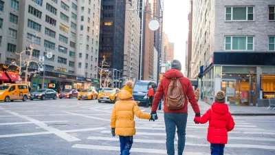
Eleven ways to make a city more walkable.

The Institute for Transportation and Development Policy (ITDP) released a new "Pedestrians First: Tools for a Walkable City" report this week, to "facilitate the understanding and the measurement of the features that promote walkability in urban environments around the world at multiple levels."
A post on the ITDP explains more about the potential benefits of walkability as the world's population grows. "With a better global understanding of walkability, and more consistent and frequent measurement of the walkability of urban environments, decision-makers will be empowered to enact policies that create more walkable urban areas," according to the post.
The new walkability tool proposes 11 indicators for measuring walkability, which the source article and the report itself describe in much more detail:
- Walkways
- Crosswalks
- Visually Active Frontage
- Physically Permeable Frontage
- Shade and Shelter
- Small Blocks
- Prioritized Connectivity
- Complementary Uses
- Access to Local Services
- Driveway Density
- Roadway Area
FULL STORY: Pedestrians First: A New Tool for Walkable Cities

The Natalist Case For Sprawl (And Why It Fails)
Some commentators defend anti-urban government policies such as exclusionary zoning on the basis that homeowning suburbanites have high birth rates. But this doesn't seem to be true in recent decades.
Off-Street Parking in the Midburbs
In several New Jersey cities, eliminating parking requirements has boosted local businesses.

Planning Communities for Thriving Children
When it comes to children's health and economic success, current trends are dismal. New research identifies how to plan communities where children can thrive. The secret? Compact, mixed-income, multimodal neighborhoods.

Planetizen Federal Action Tracker
A weekly monitor of how Trump’s orders and actions are impacting planners and planning in America.

Maui's Vacation Rental Debate Turns Ugly
Verbal attacks, misinformation campaigns and fistfights plague a high-stakes debate to convert thousands of vacation rentals into long-term housing.

San Francisco Suspends Traffic Calming Amidst Record Deaths
Citing “a challenging fiscal landscape,” the city will cease the program on the heels of 42 traffic deaths, including 24 pedestrians.

Amtrak Rolls Out New Orleans to Alabama “Mardi Gras” Train
The new service will operate morning and evening departures between Mobile and New Orleans.

The Subversive Car-Free Guide to Trump's Great American Road Trip
Car-free ways to access Chicagoland’s best tourist attractions.

San Antonio and Austin are Fusing Into one Massive Megaregion
The region spanning the two central Texas cities is growing fast, posing challenges for local infrastructure and water supplies.
Urban Design for Planners 1: Software Tools
This six-course series explores essential urban design concepts using open source software and equips planners with the tools they need to participate fully in the urban design process.
Planning for Universal Design
Learn the tools for implementing Universal Design in planning regulations.
Heyer Gruel & Associates PA
JM Goldson LLC
Custer County Colorado
City of Camden Redevelopment Agency
City of Astoria
Transportation Research & Education Center (TREC) at Portland State University
Jefferson Parish Government
Camden Redevelopment Agency
City of Claremont