


A new interactive maps brings a visual reality to the scale of displacement effected by urban renewal of the 1950s and 1960s.
The latest mapping project from the University of Richmond: "Renewing Inequality," documents the displacement and racial dynamics of urban renewal in the United States between 1955-1966.
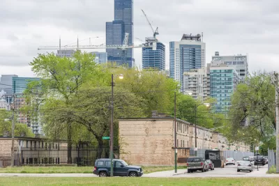
Whet Moser shares news of the new project, focusing specifically on the project's insights for Chicago, where 81,243 people, or 2.24 percent of the city's population, was displaced. "About one-third of displacements in Chicago came from two urban renewal projects: Hyde Park-Kenwood, which displaced about 4,000 families, and Lake Meadows, which displaced another 3,400 families," explains Moser. The article includes more details on the history and outcomes of urban renewal during this period in Chicago.
As noted by Moser, the "Renewing Inequality" project provides a compelling follow up to the University of Richmond's work on the redlining maps that raised awareness about the effects of 20th century zoning and home loan policies.
FULL STORY: Chicago’s Urban Renewal Displaced An Astonishing Number of People in the 20th Century


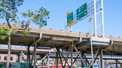
The Foundational Myth of America's Interstate Highway System
The erroneous belief that the negative impacts of interstate highways are simply "unintended consequences" fails to demand accountability for the project's failures.
‘Reconnecting Communities’ Could Fund Highway Expansions
Applications to the program reveal a pattern of state agencies requesting funds for projects that perpetuate car-centric development with only nominal equity components.

Mapping Richmond’s Displaced Communities
A new project catalogs the city’s history of displacement and its impact on communities of color.

Planetizen Federal Action Tracker
A weekly monitor of how Trump’s orders and actions are impacting planners and planning in America.

Congressman Proposes Bill to Rename DC Metro “Trump Train”
The Make Autorail Great Again Act would withhold federal funding to the system until the Washington Metropolitan Area Transit Authority (WMATA), rebrands as the Washington Metropolitan Authority for Greater Access (WMAGA).

The Simple Legislative Tool Transforming Vacant Downtowns
In California, Michigan and Georgia, an easy win is bringing dollars — and delight — back to city centers.

The States Losing Rural Delivery Rooms at an Alarming Pace
In some states, as few as 9% of rural hospitals still deliver babies. As a result, rising pre-term births, no adequate pre-term care and "harrowing" close calls are a growing reality.

The Small South Asian Republic Going all in on EVs
Thanks to one simple policy change less than five years ago, 65% of new cars in this Himalayan country are now electric.

DC Backpedals on Bike Lane Protection, Swaps Barriers for Paint
Citing aesthetic concerns, the city is removing the concrete barriers and flexposts that once separated Arizona Avenue cyclists from motor vehicles.
Urban Design for Planners 1: Software Tools
This six-course series explores essential urban design concepts using open source software and equips planners with the tools they need to participate fully in the urban design process.
Planning for Universal Design
Learn the tools for implementing Universal Design in planning regulations.
Smith Gee Studio
City of Charlotte
City of Camden Redevelopment Agency
City of Astoria
Transportation Research & Education Center (TREC) at Portland State University
US High Speed Rail Association
City of Camden Redevelopment Agency
Municipality of Princeton (NJ)