


Chicago's 606 has proven popular among pedestrians, but the rise in property values near the amentity has made some feel unwelcome near the trail. Closing a stretch of the trail for a $200-a-plate dinner only makes that worse.
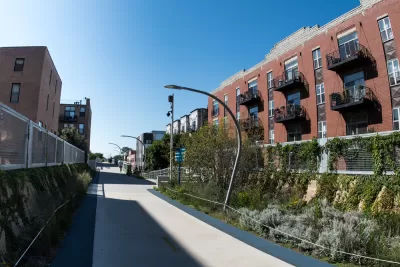
It's not uncommon for parks to close for a charity event, but closing the 606 during rush hour for a ritzy dinner, even for charity, seems tone deaf.
Residents living near Chicago's 606 trail have voiced concerns that they will be displaced by rising property values tied to the city amenity. A recent study seems to confirm those fears. "If the city is going to gain local support for trail projects in these and other gentrifying or lower-income communities, residents need some guarantees that they’ll be able to stay in communities, so that they can enjoy the benefits of the trails in the future," John Greenfield writes in Streetsblog.
The $200-a-plate dinner hosted by Rick Bayless was hosted on a stretch on the 606 that passes through the Bucktown Neighborhood, funds from the dinner went to support Chicago Parks Foundation and the Frontera Family Farmer Foundation. "The trail closure for the event, which was supposed to last from 6 p.m. Friday to 6 a.m. Saturday, but actually started at 4 p.m., according to a report from DNAinfo’s Alisa Hauser, represented a minor headache for trail users," Greenfield, writes the bigger issue is message sent to those who fear being replaced by richer residents.
FULL STORY: Closing Trails for Fancy Events Sends the Wrong Message


Obama Library Displacement Concerns: City Council Falls Short of Local Demands
The Chicago City Council has approved an ordinance intended to protect residents of the neighborhoods surrounding the planned Barack Obama Presidential Center.
More Cities Pressing Pause on Development as Gentrification, Displacement Concerns Persist
Chicago and Atlanta both approved development moratoriums in areas surrounding new urban amenities this year. Other cities could soon add to the number.
Chicago's 606 Bike Path Made Gentrification Inevitable, Expert Claims
Because the rails to trails project left housing up to the market, rising rents were inevitable, claims a new report.

Planetizen Federal Action Tracker
A weekly monitor of how Trump’s orders and actions are impacting planners and planning in America.

DARTSpace Platform Streamlines Dallas TOD Application Process
The Dallas transit agency hopes a shorter permitting timeline will boost transit-oriented development around rail stations.

Congressman Proposes Bill to Rename DC Metro “Trump Train”
The Make Autorail Great Again Act would withhold federal funding to the system until the Washington Metropolitan Area Transit Authority (WMATA), rebrands as the Washington Metropolitan Authority for Greater Access (WMAGA).

Supreme Court Ruling in Pipeline Case Guts Federal Environmental Law
The decision limits the scope of a federal law that mandates extensive environmental impact reviews of energy, infrastructure, and transportation projects.

Texas State Bills to Defund Dallas Transit Die
DART would have seen a 30% service cut, $230M annual losses had the bills survived.

Bikeshare for the Win: Team Pedals to London Cricket Match, Beats Rivals Stuck in Traffic
While their opponents sat in gridlock, England's national cricket team hopped Lime bikes, riding to a 3-0 victory.
Urban Design for Planners 1: Software Tools
This six-course series explores essential urban design concepts using open source software and equips planners with the tools they need to participate fully in the urban design process.
Planning for Universal Design
Learn the tools for implementing Universal Design in planning regulations.
Roanoke Valley-Alleghany Regional Commission
City of Mt Shasta
City of Camden Redevelopment Agency
City of Astoria
Transportation Research & Education Center (TREC) at Portland State University
US High Speed Rail Association
City of Camden Redevelopment Agency
Municipality of Princeton (NJ)