


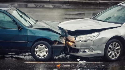
A downward trend in deaths from car crashes reversed sharply in 2015. Many blamed cell phones and the distractions they can cause, but a recent study complicates that hypothesis.

A study investigating deaths from car crashes found a correlation between warmer weather, vehicle miles traveled (VMT), and, ultimately, deaths on the road. Conducted by Dr. Leon Robertson, formerly of Yale University, the study found that 2015 was a particularly warm year in the U.S. and suggests this might be why it was such a deadly year on the streets. "Road deaths in the U.S. jumped 7 percent in 2015, to 35,200 — an abrupt reversal of the downward trend that has persisted for the previous 35 years," Susan Perry writes in the Minneapolis Post.
Robertson undertook the study in part because he was not convinced by the hypothesis that the jump in deaths was attributable to distracted drivers with cell phones. Robertson points out that by 2014 cellphones were already ubiquitous in the U.S.
"[Robertson] found that for each degree increase in temperature, vehicles were driven an average of 60 extra miles per person per year. He also found that for each additional inch of rainfall, vehicles were driven an extra 66 miles per person," Perry reports. Still, this study can only show correlation (not causation) between weather and driving, especially since the participants were not surveyed.
FULL STORY: Warmer temperatures, not cell phone use, was behind recent spike in road deaths, researcher says

The Geography of Fatal Car Crashes
Where do the most traffic deaths happen?

Research Shows More Roads = More Driving
A national study shows, once again, that increasing road supply induces additional vehicle travel, particularly over the long run.
Portland Traffic Deaths Surpass 2022 Number
This year, 69 people have died in traffic crashes in Portland, Oregon, nearly twice as many as in 2018, when the city began its Vision Zero program.

Planetizen Federal Action Tracker
A weekly monitor of how Trump’s orders and actions are impacting planners and planning in America.

Maui's Vacation Rental Debate Turns Ugly
Verbal attacks, misinformation campaigns and fistfights plague a high-stakes debate to convert thousands of vacation rentals into long-term housing.

San Francisco Suspends Traffic Calming Amidst Record Deaths
Citing “a challenging fiscal landscape,” the city will cease the program on the heels of 42 traffic deaths, including 24 pedestrians.

Defunct Pittsburgh Power Plant to Become Residential Tower
A decommissioned steam heat plant will be redeveloped into almost 100 affordable housing units.

Trump Prompts Restructuring of Transportation Research Board in “Unprecedented Overreach”
The TRB has eliminated more than half of its committees including those focused on climate, equity, and cities.

Amtrak Rolls Out New Orleans to Alabama “Mardi Gras” Train
The new service will operate morning and evening departures between Mobile and New Orleans.
Urban Design for Planners 1: Software Tools
This six-course series explores essential urban design concepts using open source software and equips planners with the tools they need to participate fully in the urban design process.
Planning for Universal Design
Learn the tools for implementing Universal Design in planning regulations.
Heyer Gruel & Associates PA
JM Goldson LLC
Custer County Colorado
City of Camden Redevelopment Agency
City of Astoria
Transportation Research & Education Center (TREC) at Portland State University
Jefferson Parish Government
Camden Redevelopment Agency
City of Claremont