


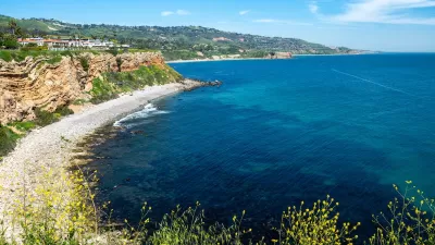
Engineers are searching for solid ground along the California coast at the scene of a massive landslide that wiped out California Highway 1 near San Luis Obispo.
"California’s restless new stretch of beachfront property in Big Sur will soon have a road," according to an article by Lisa M. Krieger.
The new road is actually just a step in the process toward a more permanent solution, but workers need to plan a route "across the loose debris field created by one of California’s largest coastal landslides in recent history" to erect a motion sensing radar. "There also are plans to start excavation on the southern side of now-buried highway just north of the San Luis Obispo County line in order to build a ledge for construction equipment," adds Krieger.
Motion sensing technology already saved lives, as workers had been evacuated from the area for several days when the slide released 2 million cubic meters of earth down the hill on May 20, 2017—earth loosened and unleashed by the winter's rains.
Now Highway 1 lies beneath some 80 feet of dirt and rock, and it could be a year before the picturesque highway is reopened.
FULL STORY: Big Sur’s brave new route crosses epic Highway 1 landslide


Landslide Strands Tourists in Big Sur
A segment of California’s famous Highway 1 collapsed, leaving the area completely cut off for a day and the southbound lane of the road still closed.
Southern California City Offers Buyout to Homeowners Facing Erosion Threat
Power and gas were shut off to dozens of homes in Rancho Palos Verdes as landslides threatened homes and infrastructure. Now, the city is offering to buy the homes to help residents relocate.

Southern California Utilities Cut Power, Gas to Hundreds of Households on Shifting Coastal Land
Slow but significant land movement is damaging infrastructure, prompting power shutoffs and calls for evacuation in Rancho Palos Verdes.

Planetizen Federal Action Tracker
A weekly monitor of how Trump’s orders and actions are impacting planners and planning in America.

San Francisco's School District Spent $105M To Build Affordable Housing for Teachers — And That's Just the Beginning
SFUSD joins a growing list of school districts using their land holdings to address housing affordability challenges faced by their own employees.

The Tiny, Adorable $7,000 Car Turning Japan Onto EVs
The single seat Mibot charges from a regular plug as quickly as an iPad, and is about half the price of an average EV.

Austin's First Single Stair Apartment Building is Officially Underway
Eliminating the requirement for two staircases in multi-story residential buildings lets developers use smaller lots and more flexible designs to create denser housing.

Atlanta Bus System Redesign Will Nearly Triple Access
MARTA's Next Gen Bus Network will retool over 100 bus routes, expand frequent service.

Toronto Condo Sales Drop 75%
In two of Canada’s most expensive cities, more condos were built than ever — and sales are plummeting.
Urban Design for Planners 1: Software Tools
This six-course series explores essential urban design concepts using open source software and equips planners with the tools they need to participate fully in the urban design process.
Planning for Universal Design
Learn the tools for implementing Universal Design in planning regulations.
Smith Gee Studio
City of Charlotte
City of Camden Redevelopment Agency
City of Astoria
Transportation Research & Education Center (TREC) at Portland State University
US High Speed Rail Association
City of Camden Redevelopment Agency
Municipality of Princeton (NJ)