


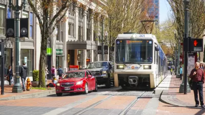
Portland planners are picking up and dusting off an idea that's been around since the 1990s: a subway in Downtown Portland.
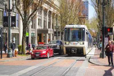
"Portland-area transportation planners are looking underground for a potential big-ticket project: a subway that runs beneath the downtown core and across the Willamette River," reports Elliot Njus.
Portland Bureau of Transportation (PBOT) planners included the idea Tuesday in a presentation before the Portland Planning and Sustainability Commission on the "Enhanced Transit Corridors Plan," which will inform an updated Regional Transportation Plan expected in 2018. The 30- to 4-year timeline for the plan reflects the speculative status of any subway project that might move forward, despite the fact that the idea has been floated in one for another since the 1990s.
According to Njus, current versions of the plan include "more concrete proposals for speeding up the region's transit system," such as "pilots of transit-only lanes, priority traffic signals, bus stop consolidation and other low-cost changes designed to help frequent-service buses move faster in the city's resurgent traffic congestion."
FULL STORY: City planners float idea of subway tunnel through downtown Portland

Federal Approval Clears Way for Bus-Only Lanes in Portland
Portland will soon be spreading out the red carpet for buses.
Transit Planners Studying a Tunnel Under Portland
Oregon Metro and TriMet are studying the feasibility of a subway tunnel under Portland that would cross under the Willamette River to speed up MAX trains through the city.
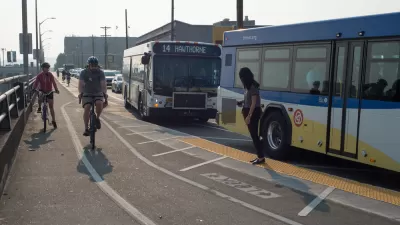
Portland Looking for Ways to Speed Up Buses, Protect Pedestrians
Freeing buses from congestion and protecting pedestrians from speeding cars are two of the goals expressed by the Central City in Motion planning process.

Maui's Vacation Rental Debate Turns Ugly
Verbal attacks, misinformation campaigns and fistfights plague a high-stakes debate to convert thousands of vacation rentals into long-term housing.

Planetizen Federal Action Tracker
A weekly monitor of how Trump’s orders and actions are impacting planners and planning in America.

San Francisco Suspends Traffic Calming Amidst Record Deaths
Citing “a challenging fiscal landscape,” the city will cease the program on the heels of 42 traffic deaths, including 24 pedestrians.

Defunct Pittsburgh Power Plant to Become Residential Tower
A decommissioned steam heat plant will be redeveloped into almost 100 affordable housing units.

Trump Prompts Restructuring of Transportation Research Board in “Unprecedented Overreach”
The TRB has eliminated more than half of its committees including those focused on climate, equity, and cities.

Amtrak Rolls Out New Orleans to Alabama “Mardi Gras” Train
The new service will operate morning and evening departures between Mobile and New Orleans.
Urban Design for Planners 1: Software Tools
This six-course series explores essential urban design concepts using open source software and equips planners with the tools they need to participate fully in the urban design process.
Planning for Universal Design
Learn the tools for implementing Universal Design in planning regulations.
Heyer Gruel & Associates PA
JM Goldson LLC
Custer County Colorado
City of Camden Redevelopment Agency
City of Astoria
Transportation Research & Education Center (TREC) at Portland State University
Jefferson Parish Government
Camden Redevelopment Agency
City of Claremont