


An Star Tribune analysis finds residents in the Twin Cities region are generously supporting the transportation infrastructure spending of the rest of the state.
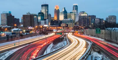
"Greater Minnesota gets far more money for roads and bridges than its residents pay in taxes for those projects, a new Star Tribune analysis of transportation funding has found," report J. Patrick Coolican and Mary Jo Webster. Throughout the article, the "Metro" is used to describe counties in the Twin Cities metropolitan area, while "Greater Minnesota" is used to describe the rest of the state.
"The review found that metro and greater Minnesota taxpayers each provide about half the money for Minnesota’s roads and bridges, but greater Minnesota gets twice as much back in projects," add Coolican and Webster. To be exact, Metro area counties generate 52 percent of the state's vehicles sales tax, vehicle registration fees, and fuel taxes revenues. However, the same counties only receive 32 percent of the state's transportation investment.
According to the article, the findings of the analysis "contradicts a commonly held perception in greater Minnesota — and one heard often in political campaigns — that the metro is taking more than it gives." That common misconception is not unique to Minnesota, of course.
The analysis emerges as Republican Senate leaders "are planning to review their 10-year transportation funding plan," and while debate regarding the Southwest light rail project continues at the state and regional levels.
FULL STORY: Metro contributes roughly half of state transportation dollars, gets fewer in return


Property Tax Could Fund $7 Billion Transit Plan in Austin, Displacement Mitigation Included
A $7 billion transit investment plan for Austin would include $300 million toward preventing displacement of communities in neighborhoods located near planned transit investments.
SEPTA Ready to Roll Out Major Capital Investments
Budgets reflect priorities, and the Southeastern Pennsylvania Transportation Authority will be prioritizing capital investments in the 2018 fiscal year.
Trump Budget Blueprint Would Nix Federal Transit Spending
Reports from inside the Trump transition are that the incoming administration will follow a budget blueprint laid out by the Heritage Foundation—public transit not included.

Planetizen Federal Action Tracker
A weekly monitor of how Trump’s orders and actions are impacting planners and planning in America.

Congressman Proposes Bill to Rename DC Metro “Trump Train”
The Make Autorail Great Again Act would withhold federal funding to the system until the Washington Metropolitan Area Transit Authority (WMATA), rebrands as the Washington Metropolitan Authority for Greater Access (WMAGA).

DARTSpace Platform Streamlines Dallas TOD Application Process
The Dallas transit agency hopes a shorter permitting timeline will boost transit-oriented development around rail stations.

LA County Creating Action Plan to Tackle Extreme Heat
Los Angeles County is creating a Heat Action Plan to help communities stay safe during extreme heat, with steps like adding more shade, improving buildings, and supporting the neighborhoods most at risk.

Maryland Plans Quick-Build Complete Streets Projects
The state will use low-cost interventions to improve road safety in five Maryland counties.

Downtown Los Angeles Gears Up for Growth
A new report highlights Downtown L.A.’s ongoing revival through major housing projects, adaptive reuse, hospitality growth, and preparations for global events in the years ahead.
Urban Design for Planners 1: Software Tools
This six-course series explores essential urban design concepts using open source software and equips planners with the tools they need to participate fully in the urban design process.
Planning for Universal Design
Learn the tools for implementing Universal Design in planning regulations.
City of Charlotte
Municipality of Princeton
Roanoke Valley-Alleghany Regional Commission
City of Camden Redevelopment Agency
City of Astoria
Transportation Research & Education Center (TREC) at Portland State University
US High Speed Rail Association
City of Camden Redevelopment Agency
Municipality of Princeton (NJ)