


The Geary bus corridor was the #1 pick for a subway according to a Muni survey, but commuters will have to settle for bus rapid transit. A milestone was reached when the San Francisco County Transportation Authority approved the design and EIR.
"The Board of Supervisors, acting as the San Francisco County Transportation Authority, voted 10-0 with Supervisor Scott Wiener absent, to select a design that puts 1.7 miles of dedicated bus lanes in the median through the heart [see map] of the Richmond District," writes Michael Cabanatuan, transportation reporter for the San Francisco Chronicle.
The SFCTA commissioners also unanimously approved the Final Environmental Impact Report (EIR) for the project, named for the corridor on which it travels, Geary Corridor Bus Rapid Transit.
"Muni’s 38-Geary bus lines carry about 52,000 passengers a day," notes Cabanatuan, the highest ridership in the city, and "one of the most used bus lines in the United States," according to the Geary Corridor BRT fact sheet (PDF). The corridor was also top choice selected for a "new subway line in a recent survey conducted by the San Francisco Municipal Transportation Agency (SFMTA)," reported Amy Graff for The Chronicle last October.
First Bus Rapid Transit (BRT) project
In September 2013, the authority's board unanimously approved the Van Ness Avenue Bus Rapid Transit project and certified its Environmental Impact Report, "clearing the way for design and implementation," according to their joint press release with San Francisco Municipal Transportation Agency [PDF]. Last month, that project received a federal infusion of $75 million in grant funds from the Federal Transit Administration.
Project marked by delay, more to come
A 2006 Planetizen post, also based on a report by Michael Cabanatuan in The Chronicle, predicted that service on both Van Ness and Geary BRT lines would be operating by 2010. But the Geary line is fiercely opposed by "merchants and residents who fear lost parking and increased congestion will drive away business," updates Cabanatuan.
[M]ore hearings, and votes, must still come before the Municipal Transportation Agency [SFMTA or Muni] can start building the $300 million faster bus rapid transit system, tentatively scheduled to start carrying passengers by 2021.
In an opinion piece in The Chronicle printed on Jan. 5, the day the SFCTA voted on the EIR, leaders of the Planning Association of the Richmond advocated an alternative design for the project based on an "incremental approach: more buses, tighter schedules, repaving, better synchronization of traffic lights, upgraded bus-driver controls to extend green lights briefly, fewer 'Rapid' stops and better stations."
Design
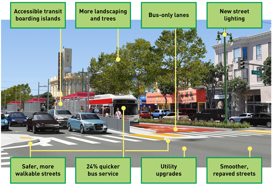
The rendering above shows a station stop and is not typical of the line. Best to click on video below to view the "hybrid solution" composed of side-running and center-running lanes, the latter mostly not being separated, as pictured above but "red-carpet", though still considered "dedicated."
=======================================
Related in Planetizen:
- Feds Put $75 Million Toward San Francisco BRT Project, December 29, 2016: The $223 million Van Ness Bus Rapid Transit project in San Francisco received a major cash infusion from the federal government this week.
- San Francisco To Implement Bus Rapid Transit Service By 2010, November 9, 2006: While late to adopt bus rapid transit, San Francisco's Muni is planning to bring fully-fledged BRT lines, complete with dedicated lanes, to the city by 2010.
FULL STORY: Upgrade of Muni’s Geary bus line moves forward

San Francisco's First BRT Line Closer to Opening
The Van Ness Avenue Bus Rapid Transit project will bring the first dedicated BRT corridor to San Francisco, nearly two decades after voters approved the project.

FHWA Greenlights More Red Lanes for Buses in San Francisco
The Federal Highway Administration approved 50 applications of red transit-only lanes to be painted throughout San Francisco. Already used on four streets in a pilot program, the lanes have proven effective but are opposed by some business owners.
Feds Put $75 Million Toward San Francisco BRT Project
The $223 million Van Ness Bus Rapid Transit project in San Francisco received a major cash infusion from the federal government this week.

Planetizen Federal Action Tracker
A weekly monitor of how Trump’s orders and actions are impacting planners and planning in America.

Canada vs. Kamala: Whose Liberal Housing Platform Comes Out on Top?
As Canada votes for a new Prime Minister, what can America learn from the leading liberal candidate of its neighbor to the north?

The Five Most-Changed American Cities
A ranking of population change, home values, and jobs highlights the nation’s most dynamic and most stagnant regions.

San Diego Adopts First Mobility Master Plan
The plan provides a comprehensive framework for making San Diego’s transportation network more multimodal, accessible, and sustainable.

Housing, Supportive Service Providers Brace for Federal Cuts
Organizations that provide housing assistance are tightening their purse strings and making plans for maintaining operations if federal funding dries up.

Op-Ed: Why an Effective Passenger Rail Network Needs Government Involvement
An outdated rail network that privileges freight won’t be fixed by privatizing Amtrak.
Urban Design for Planners 1: Software Tools
This six-course series explores essential urban design concepts using open source software and equips planners with the tools they need to participate fully in the urban design process.
Planning for Universal Design
Learn the tools for implementing Universal Design in planning regulations.
New York City School Construction Authority
Village of Glen Ellyn
Central Transportation Planning Staff/Boston Region MPO
Institute for Housing and Urban Development Studies (IHS)
City of Grandview
Harvard GSD Executive Education
Regional Transportation Commission of Southern Nevada
Toledo-Lucas County Plan Commissions