


Political leaders are still seeking support for the Lake Ontario-St. Lawrence River Plan 2014, which has been circulating since November 2014.
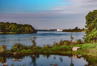
Congresswoman Elise Stefanik (R-NY) writes an op-ed supporting Lake Ontario-St. Lawrence River Plan 2014 (Plan 2014), arguing that the plan will better regulate the waters of the North Country.
"Plan 2014 will better regulate water levels through the Moses-Saunders Power Dam as well as outline the conditions needed to change water levels and maintain the proper ecological balance," according to Congresswoman Stefanik.
"The current outdated water level plan" is "wiping out habitat" and "[clearing] a path for invasive species," according to Congresswoman Stefanik. "Plan 2014 would return Lake Ontario and the St. Lawrence to more natural levels and a normal hydrologic cycle," writes Congresswoman Stefanik, "protecting our ecology and helping to preserve the long term health of the lake."
TheInternational Joint Commission referred Plan 2014 to U.S. Secretary of State John Kerry and Canadian Foreign Affairs Minister Stéphane Dion in November 2014. A recent round of public outreach, including an online petition and Congresswoman Stefanik's op-ed, is attempting to drum up the final necessary support for the plan's approval.
FULL STORY: NOW IS THE TIME FOR PLAN 2014. PROTECTING OUR NATURAL TREASURES CANNOT WAIT

Opinion: Climate Change Has Brought the 'Era of Extreme' to the Great Lakes
Severe flooding in these coastal areas will become the norm, but how to best address the environmental challenges is not entirely clear.
Toronto River Project Will Provide Greenspace and Flood Control
The massive Port Lands infrastructure project will transform an industrial area by carving out a new island.
Great Lakes Leaders Call for Drinking Water Protections
In light of August's drinking water catastrophe in Toledo, Ohio, Great Lakes mayors gathered this week to call for policy action to protect water resources round the Great Lakes.

Maui's Vacation Rental Debate Turns Ugly
Verbal attacks, misinformation campaigns and fistfights plague a high-stakes debate to convert thousands of vacation rentals into long-term housing.

Planetizen Federal Action Tracker
A weekly monitor of how Trump’s orders and actions are impacting planners and planning in America.

Chicago’s Ghost Rails
Just beneath the surface of the modern city lie the remnants of its expansive early 20th-century streetcar system.

Bend, Oregon Zoning Reforms Prioritize Small-Scale Housing
The city altered its zoning code to allow multi-family housing and eliminated parking mandates citywide.

Amtrak Cutting Jobs, Funding to High-Speed Rail
The agency plans to cut 10 percent of its workforce and has confirmed it will not fund new high-speed rail projects.

LA Denies Basic Services to Unhoused Residents
The city has repeatedly failed to respond to requests for trash pickup at encampment sites, and eliminated a program that provided mobile showers and toilets.
Urban Design for Planners 1: Software Tools
This six-course series explores essential urban design concepts using open source software and equips planners with the tools they need to participate fully in the urban design process.
Planning for Universal Design
Learn the tools for implementing Universal Design in planning regulations.
planning NEXT
Appalachian Highlands Housing Partners
Mpact (founded as Rail~Volution)
City of Camden Redevelopment Agency
City of Astoria
City of Portland
City of Laramie