


Some things are worth waiting for, including the Tualatin River Greenway Bicycle and Pedestrian Shared Use Path.

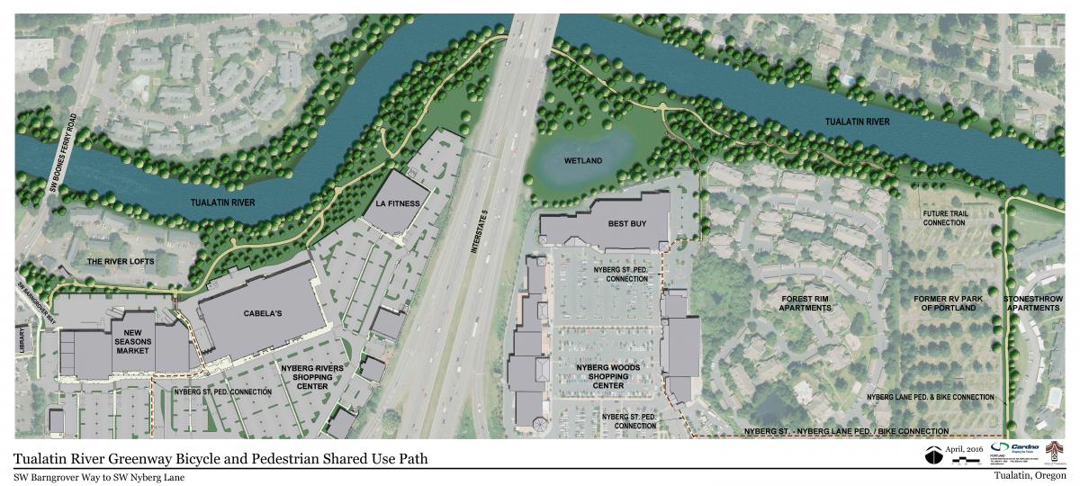
"More than three decades ago, parks planners started talking about and planning for the Tualatin River Greenway Bicycle and Pedestrian Shared Use Path," according to an article by Allan Brettman. "In all the years since, a grand total of 4.7 miles of trail have been developed along the river, stretching from Tigard to Durham and Tualatin."
Last April, a three-quarter mile section of the Tualatin River Greenway Bicycle and Pedestrian Shared Use Path opened to the public. The new stretch "not only provides a smooth, wide path next to the river but also offers a lesson on the geologic history of the Willamette Valley," according to Brettman. That history lessons spans an 18,000-year "geologic journey from the Ice Age to pioneer settlement in the Willamette Valley, with creative use of crushed blue glass, and footprints representing mastodon's and the first native Americans to settle the area."
"Geologic time is also marked by black granite bands that label the years of eruptions for Mount St. Helens and Mount Mazama – predecessor to Crater Lake," adds Brettman.
FULL STORY: Inch by glacial inch, Tualatin River Greenway became reality

Detroit Opens Segment of Joe Lewis Greenway
The newly opened segment, which features playground equipment and public lawns, is part of a 27.5 mile greenway that will loop through four cities.
Study: Recreational Trails Program Underfunded by Over $200 Million
FHA research shows that multi-use trail users contribute three times as much in gas taxes as the program to build and maintain them receives.

Baltimore's 'Big Jump'
A temporary bike and pedestrian path is changing the street design game in Baltimore.

Planetizen Federal Action Tracker
A weekly monitor of how Trump’s orders and actions are impacting planners and planning in America.

Map: Where Senate Republicans Want to Sell Your Public Lands
For public land advocates, the Senate Republicans’ proposal to sell millions of acres of public land in the West is “the biggest fight of their careers.”

Restaurant Patios Were a Pandemic Win — Why Were They so Hard to Keep?
Social distancing requirements and changes in travel patterns prompted cities to pilot new uses for street and sidewalk space. Then it got complicated.

California Homeless Arrests, Citations Spike After Ruling
An investigation reveals that anti-homeless actions increased up to 500% after Grants Pass v. Johnson — even in cities claiming no policy change.

Albuquerque Route 66 Motels Become Affordable Housing
A $4 million city fund is incentivizing developers to breathe new life into derelict midcentury motels.

DC Area County Eliminates Bus Fares
Montgomery County joins a growing trend of making transit free.
Urban Design for Planners 1: Software Tools
This six-course series explores essential urban design concepts using open source software and equips planners with the tools they need to participate fully in the urban design process.
Planning for Universal Design
Learn the tools for implementing Universal Design in planning regulations.
Heyer Gruel & Associates PA
JM Goldson LLC
Custer County Colorado
City of Camden Redevelopment Agency
City of Astoria
Transportation Research & Education Center (TREC) at Portland State University
Camden Redevelopment Agency
City of Claremont
Municipality of Princeton (NJ)