


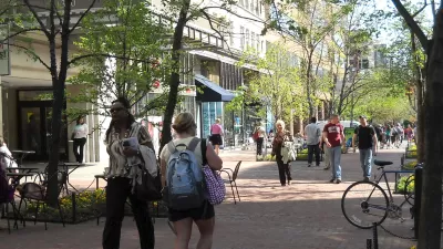
If Detroit needs to be "rebuilt" or "reimagined," why not do so around a walkable, convenient ideal? A compact Motor City where essential goods and services are available within a 20-minute walk?

"Detroit Mayor Mike Duggan recently introduced the idea of rebuilding Detroit around the concept of the 20-minute neighborhood, where folks can walk or bike to everything they need outside of work." A valiant concept to be sure, but is it realistic?
Wayne State planning professor Robin Boyle writes, "a 20-minute neighborhood is an active, safe, walkable, convenient, predominantly residential neighborhood. A place where people can get most of their day-to-day goods and services — shopping with good food, access to transit, parks and schools — within a 20-minute walk."
Density is the deciding factor, but Detroit has become renowned for shedding its density. "The mayor's initial target neighborhoods: L6 (Livernois and McNichols), Southwest Detroit and West Village on the east side might work. But the key to extending the concept is density. Are there enough households, with sufficient disposable income, to sustain the shops, the local services? Are there enough children to keep the school open and thriving?"
Success will depend on fostering areas best suited to denser amenities, which means leaving other areas out. "The 20-minute neighborhood needs a residential density of somewhere between 15 and 20 households per acre to support local retail. Outside of the downtown/Midtown corridor and a select number of more dense, occupied neighborhoods, most of Detroit has a lower residential density."
FULL STORY: Could the 20-minute neighborhood work in Detroit?


From Paris to Portland: The 15-Minute City Goes Mainstream
Raising the bar on the 20-minute neighborhood model, cities around the world are embracing the appeal of the 15-minute city during the coronavirus pandemic.
Cities Seeking '20-Minute Living'
Reducing car dependency can improve air quality, increase access to jobs and opportunities, and help cities meet emissions reduction goals.
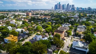
Seeking '20-Minute Neighborhood' Status in Texas
The neighborhood of Montrose in Houston has undertaken a self-funded study to assess the facts on the ground about walkability in the neighborhood.

Maui's Vacation Rental Debate Turns Ugly
Verbal attacks, misinformation campaigns and fistfights plague a high-stakes debate to convert thousands of vacation rentals into long-term housing.

Planetizen Federal Action Tracker
A weekly monitor of how Trump’s orders and actions are impacting planners and planning in America.

In Urban Planning, AI Prompting Could be the New Design Thinking
Creativity has long been key to great urban design. What if we see AI as our new creative partner?

King County Supportive Housing Program Offers Hope for Unhoused Residents
The county is taking a ‘Housing First’ approach that prioritizes getting people into housing, then offering wraparound supportive services.

Researchers Use AI to Get Clearer Picture of US Housing
Analysts are using artificial intelligence to supercharge their research by allowing them to comb through data faster. Though these AI tools can be error prone, they save time and housing researchers are optimistic about the future.

Making Shared Micromobility More Inclusive
Cities and shared mobility system operators can do more to include people with disabilities in planning and operations, per a new report.
Urban Design for Planners 1: Software Tools
This six-course series explores essential urban design concepts using open source software and equips planners with the tools they need to participate fully in the urban design process.
Planning for Universal Design
Learn the tools for implementing Universal Design in planning regulations.
planning NEXT
Appalachian Highlands Housing Partners
Mpact (founded as Rail~Volution)
City of Camden Redevelopment Agency
City of Astoria
City of Portland
City of Laramie