


A photo series documents some of the many different U.S. streets named to honor MLK.
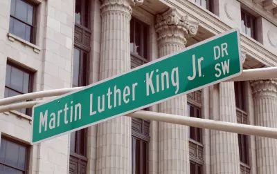
CityLab shares selections from photographer Susan Berger, who set out to capture some of the 900+ streets in the United States named for Martin Luther King, Jr.
Berger reflects on the differences she noticed in the upkeep and centrality of those streets from city to city.
For instance:
Berger made a point to visit those cities most closely associated with the Civil Rights movements. In some of those places, the placement of MLK streets testifies to his enduring local significance. In Little Rock, Martin Luther King Dr. runs right up against the state capitol buildings; in Atlanta, it’s a long street that cuts through the entire swath of the city, from government buildings to residential neighborhoods, intersecting a range of socioeconomic levels.
But research has also shown that streets named for MLK tend to be associated with "lower incomes and higher rates of racial segregation than city-wide and national norms":
Some of Berger’s photographs, like those she took in Houston, Texas, reflect this truth in broken chain-link fences and abandoned parking lots. In these neighborhoods, the MLK-named streets serve as a reminder of the man himself, and all that he did and dreamed of. “At the same time, though, you look at the neighborhood and say: what has been accomplished? To what extent had that dream been realized?” Berger says.
Over the years, there have been efforts by non-profits to revitalize those streets; the city of Atlanta also recently took steps to transform its MLK Drive.
FULL STORY: Photographing the Streets Named for Martin Luther King Jr.

Revitalizing MLK Streets to Better Honor Their Namesake
Across the U.S., hundreds of streets are named in honor of Dr. Martin Luther King Jr. Unfortunately, many reflect the poverty and segregation that King fought to reverse. A non-profit is trying to transform them into sources of pride and inspiration.

DOJ: ‘Nuisance’ Evictions Could Break Federal Law
Ordinances that allow landlords to evict tenants for nuisance complaints or alleged criminal activity may run afoul of federal protections, the DOJ warns.

‘Ground-Breaking’ Settlement Reached in Detroit Environmental Justice Case
Civil rights activists celebrate a legal settlement that will require the state of Michigan to prevent hazardous waste and other industrial facilities from disproportionately polluting lower income and predominantly Black and brown communities.

Planetizen Federal Action Tracker
A weekly monitor of how Trump’s orders and actions are impacting planners and planning in America.

Restaurant Patios Were a Pandemic Win — Why Were They so Hard to Keep?
Social distancing requirements and changes in travel patterns prompted cities to pilot new uses for street and sidewalk space. Then it got complicated.

Map: Where Senate Republicans Want to Sell Your Public Lands
For public land advocates, the Senate Republicans’ proposal to sell millions of acres of public land in the West is “the biggest fight of their careers.”

Maui's Vacation Rental Debate Turns Ugly
Verbal attacks, misinformation campaigns and fistfights plague a high-stakes debate to convert thousands of vacation rentals into long-term housing.

San Francisco Suspends Traffic Calming Amidst Record Deaths
Citing “a challenging fiscal landscape,” the city will cease the program on the heels of 42 traffic deaths, including 24 pedestrians.

California Homeless Arrests, Citations Spike After Ruling
An investigation reveals that anti-homeless actions increased up to 500% after Grants Pass v. Johnson — even in cities claiming no policy change.
Urban Design for Planners 1: Software Tools
This six-course series explores essential urban design concepts using open source software and equips planners with the tools they need to participate fully in the urban design process.
Planning for Universal Design
Learn the tools for implementing Universal Design in planning regulations.
Heyer Gruel & Associates PA
JM Goldson LLC
Custer County Colorado
City of Camden Redevelopment Agency
City of Astoria
Transportation Research & Education Center (TREC) at Portland State University
Camden Redevelopment Agency
City of Claremont
Municipality of Princeton (NJ)