


Designed by the same landscape architect behind New York City's High Line, a new park will cap San Francisco's Doyle Drive, connecting the Presidio to the shoreline.
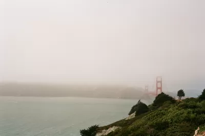
Nestled just south of the Golden Gate Bridge, a new section of parkland will connect the Presidio to the water. Nate Berg writes, "The Doyle Drive replacement, completed in 2015, is tucked inside concrete tunnels, the roofs of which will serve as green bridges linking the two sections of the Presidio that were separated in the 1930s." The cap park heals a physical divide that became very acute after the Presidio ceased its service as a U.S. Army base in 1994.
According to James Corner, of James Corner Field Operations, "'When you step out on the tunnel tops, you really get a 360-degree, geographical sort of centering vantage point where you can take in every landmark and every place that's significant in San Francisco and the bay.'" Corner's firm also designed New York's High Line, which has received significant attention and praise.
Covering freeways with parkland is an idea that has become increasingly popular nationwide. "In Dallas, for example, the 5.2‑acre Klyde Warren Park opened in 2012 on a platform over a sunken section of freeway. Los Angeles and Seattle are now considering similar freeway-cap parks."
FULL STORY: San Francisco’s Plan to Bury a Freeway


Montreal Mall to Become 6,000 Housing Units
Place Versailles will be transformed into a mixed-use complex over the next 25 years.

Planetizen Federal Action Tracker
A weekly monitor of how Trump’s orders and actions are impacting planners and planning in America.

DARTSpace Platform Streamlines Dallas TOD Application Process
The Dallas transit agency hopes a shorter permitting timeline will boost transit-oriented development around rail stations.

Interactive Map Reveals America's “Shade Deserts”
Launched by UCLA and American Forests to combat heat-related deaths, the tool maps the shade infrastructure for over 360 U.S. cities.

Bicycles and Books — In Sacramento, Libraries Now Offer Both
Adult library card holders can check out e-bikes and e-trikes for up to one week.

Colorado Landfills Emit as Much Pollution as 1M Cars
Landfills are the third-largest source of methane pollution in Colorado, after agriculture and fossil fuel extraction.
Urban Design for Planners 1: Software Tools
This six-course series explores essential urban design concepts using open source software and equips planners with the tools they need to participate fully in the urban design process.
Planning for Universal Design
Learn the tools for implementing Universal Design in planning regulations.
City of Mt Shasta
City of Camden Redevelopment Agency
City of Astoria
Transportation Research & Education Center (TREC) at Portland State University
City of Camden Redevelopment Agency
Municipality of Princeton (NJ)
Regional Transportation Commission of Southern Nevada