


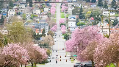
Census data shows that Seattle jumped Baltimore to become the country's tenth most densely populated city. Is Seattle on the cusp of a changing of the guard when it comes to density and population growth?

"Analysis of census data shows that Seattle — for the first time in its history — ranks among the top 10 most densely populated big cities in the U.S.," according to an article by Gene Balk.
"With 7,962 people per square mile in 2014, Seattle leapfrogged Baltimore into the No. 10 spot among the 50 most populous cities in the country. Seattle’s population density has increased by nearly 10 percent since the 2010 Census. And if current growth rates continue, we’ll bypass No. 9 Los Angeles within five years," adds Balk.
Balk places the new density figures in context of the city's ongoing development controversies, which erupted most publicly with the Housing Affordability and Livability Agenda (HALA) last year. Balk speaks extensively with Branden Born, associate professor of urban design and planning at the University of Washington, about the "D" word (density)—how the public perceives it and how they misperceive it. Born looks around the city and notes examples of density done right, as well as some example of how new development has changed the character of neighborhoods. Born predicts "a changing of the guard is under way when it comes to density and growth."
FULL STORY: Seattle among top 10 most densely populated big cities in the U.S. for first time ever

Beware of Energy Rankings for Cities
In a special "Energy for Tomorrow" report, The New York Times looks at "clean city rankings" of energy efficiency and land use. But ranking cities is no easy task—"winners on one list may appears as sinners on another."

Seattle’s Upzoning Plan is Ambitious, Light on Details
The city passed a ‘bare-bones’ framework to comply with state housing laws that paves the way for more middle housing, but the debate over how and where to build is just getting started.
Opinion: Housing Versus Trees Is a False Choice; Swap Pavement for Trees Instead
Seattle’s goal to cover 30 percent of the city with tree canopy by 2037 doesn’t need to be sacrificed in favor of density. There’s a better way.

Planetizen Federal Action Tracker
A weekly monitor of how Trump’s orders and actions are impacting planners and planning in America.

Congressman Proposes Bill to Rename DC Metro “Trump Train”
The Make Autorail Great Again Act would withhold federal funding to the system until the Washington Metropolitan Area Transit Authority (WMATA), rebrands as the Washington Metropolitan Authority for Greater Access (WMAGA).

The Simple Legislative Tool Transforming Vacant Downtowns
In California, Michigan and Georgia, an easy win is bringing dollars — and delight — back to city centers.

The States Losing Rural Delivery Rooms at an Alarming Pace
In some states, as few as 9% of rural hospitals still deliver babies. As a result, rising pre-term births, no adequate pre-term care and harrowing close calls are a growing reality.

The Small South Asian Republic Going all in on EVs
Thanks to one simple policy change less than five years ago, 65% of new cars in this Himalayan country are now electric.

DC Backpedals on Bike Lane Protection, Swaps Barriers for Paint
Citing aesthetic concerns, the city is removing the concrete barriers and flexposts that once separated Arizona Avenue cyclists from motor vehicles.
Urban Design for Planners 1: Software Tools
This six-course series explores essential urban design concepts using open source software and equips planners with the tools they need to participate fully in the urban design process.
Planning for Universal Design
Learn the tools for implementing Universal Design in planning regulations.
Smith Gee Studio
City of Charlotte
City of Camden Redevelopment Agency
City of Astoria
Transportation Research & Education Center (TREC) at Portland State University
US High Speed Rail Association
City of Camden Redevelopment Agency
Municipality of Princeton (NJ)