


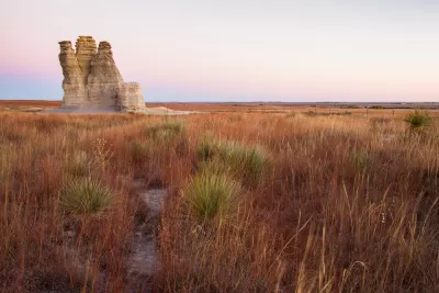
A map-making effort by The Washington Post's Wonkblog puts the Western United States' population, or lack thereof, in perspective.
"I don't know about you, but I'm a sucker for those maps that show the crazy geographic concentration of things like wealth and population," begins a recent post. He clearly wasn't talking to us at Planetizen because then he would know that we are a sucker for those maps that show crazy geographic concentration of things like wealth and population.
The map Ingraham shared with his audience on this occasion is meant to illustrate the "jaw-dropping emptiness of America." Sourced from Reddit, the original map shows "the enormous chunk of land where only 1 percent of the population lives." Ingraham updated the map for a bit more legibility and with the 2014 population numbers from the U.S. Census.
Ingraham provides a few different ways of putting the data shown on the map in perspective, in addition to offering one very specific mark of distinction:
The least-populated place in the United States is Alaska's Yukon-Koyukuk Census Area. At over 145,000 square miles, it's larger than New York, Pennsylvania, Maryland and Virginia -- combined. But it's home to only 5,547 people, for a population density of fewer than 4 people every 100 miles.
FULL STORY: Look at the jaw-dropping emptiness of America

Facebook AI Maps Population Density
Facebook expects to release its worldwide maps of human density in the coming months—potential applications will likely be somewhere on the spectrum between humanitarian and commercial.

Interactive Map Reveals America's “Shade Deserts”
Launched by UCLA and American Forests to combat heat-related deaths, the tool maps the shade infrastructure for over 360 U.S. cities.

DOT Memo Directs Transportation Funding to Communities With Higher Marriage and Birth Rates, Compliance with Immigration Officials and No Mask Mandates
The memo ties immigration enforcement to federal funding and prohibits mask or vaccine mandates.

Planetizen Federal Action Tracker
A weekly monitor of how Trump’s orders and actions are impacting planners and planning in America.

Chicago’s Ghost Rails
Just beneath the surface of the modern city lie the remnants of its expansive early 20th-century streetcar system.

San Antonio and Austin are Fusing Into one Massive Megaregion
The region spanning the two central Texas cities is growing fast, posing challenges for local infrastructure and water supplies.

Since Zion's Shuttles Went Electric “The Smog is Gone”
Visitors to Zion National Park can enjoy the canyon via the nation’s first fully electric park shuttle system.

Trump Distributing DOT Safety Funds at 1/10 Rate of Biden
Funds for Safe Streets and other transportation safety and equity programs are being held up by administrative reviews and conflicts with the Trump administration’s priorities.

German Cities Subsidize Taxis for Women Amid Wave of Violence
Free or low-cost taxi rides can help women navigate cities more safely, but critics say the programs don't address the root causes of violence against women.
Urban Design for Planners 1: Software Tools
This six-course series explores essential urban design concepts using open source software and equips planners with the tools they need to participate fully in the urban design process.
Planning for Universal Design
Learn the tools for implementing Universal Design in planning regulations.
planning NEXT
Appalachian Highlands Housing Partners
Mpact (founded as Rail~Volution)
City of Camden Redevelopment Agency
City of Astoria
City of Portland
City of Laramie